Cara Digitasi Peta Di ArcGIS Bagi Pemula Part 1
Summary
TLDRThis tutorial guides beginners on how to digitize maps in ArcGIS, focusing on creating and editing different shapefiles, such as polygons, polylines, and points. It covers setting up folders, creating shapefiles with proper coordinate systems, and using a raster image as a base for digitization. The video walks through digitizing shapes, editing polygons (adding, removing, or splitting areas), and labeling features with custom attributes. It offers step-by-step instructions to ensure users can accurately create and modify geographic data for mapping projects.
Takeaways
- 😀 Remember to create a folder in your system for storing the project data and save files before starting GIS work in ArcGIS.
- 😀 📂 Connect the folder to ArcCatalog by selecting 'Connect to Folder' and browsing to the desired folder to set up your workspace.
- 😀 🗂 When creating a new shapefile, ensure you select the correct type (Polygon, Polyline, Point) and set the appropriate coordinate system (e.g., WGS 1984).
- 😀 🗺 Add a raster dataset as a base map, then adjust the coordinate system settings for your data frame to match the base map.
- 😀 🖱 Start editing a shapefile by selecting the 'Start Editing' option and activate the 'Create Feature' tool to begin digitizing features.
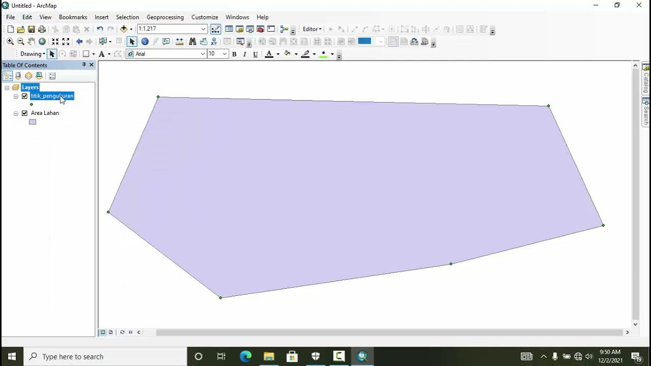
- 😀 ✏ When digitizing polygons, use the 'Create Polygon' tool and ensure to close the polygon shape by double-clicking to finalize it.
- 😀 💾 After completing digitization, always stop editing and save your edits to preserve your work.
- 😀 🔄 For editing existing polygons, use the 'Reshape Feature' tool, ensuring you select the right part of the feature to modify.
- 😀 🔪 To split polygons, use the 'Cut Polygon' tool and ensure to select the polygon before performing any cutting operation.
- 😀 🏷 Add and edit attribute data for polygons by using the 'Attribute Table' and create new fields for text or other types of data.
- 😀 🔠 To display labels for features, activate the 'Labels' option in the layer properties and choose the field (e.g., 'Description') to be displayed.
Q & A
What is the first step in preparing for digitizing a map in ArcGIS?
-The first step is to create a folder to store the project files. This folder will serve as the database for the map project.
How do you connect a folder to ArcCatalog in ArcGIS?
-To connect a folder in ArcCatalog, click on 'Catalog' on the ArcMap interface, then select 'Connect to Folder'. Choose the folder you created earlier, and click 'OK'. This will make the folder accessible in ArcCatalog.
How do you create a new shapefile in ArcGIS?
-To create a new shapefile, right-click on the folder in ArcCatalog, select 'New', then 'Shapefile'. Provide a name for the shapefile, select the geometry type (e.g., polygon, polyline, point), and set the coordinate system (e.g., WGS 1984).
What is the purpose of adding a raster image to the project?
-The raster image serves as a reference or base map for the digitization process, helping users trace and create new vector data (e.g., polygons, lines, points).
How do you start editing a shapefile for digitization?
-To start editing, right-click on the shapefile in the table of contents, select 'Edit Features', and then choose 'Start Editing'. Afterward, you can use the drawing tools to create or modify features.
What tool is used for drawing polygons in ArcGIS during digitization?
-To draw polygons, use the 'Create Features' tool in the editing toolbar. You can then use the 'Polygon' tool to trace the area you want to digitize.
How can you edit the properties of a digitized polygon in ArcGIS?
-To edit the properties, double-click on the polygon to open the 'Properties' window. Here, you can change the fill color, outline color, and thickness to modify the appearance of the polygon.
How can you add more area to an existing polygon?
-To add more area to an existing polygon, select the 'Edit Features' tool, activate the desired polygon, and then use the 'Reshape' tool to expand the boundary.
What is the procedure for splitting a polygon into two parts?
-To split a polygon, use the 'Cut Polygon' tool. First, select the polygon, then draw the cut line outside the polygon. After completing the cut, the polygon will be divided into two parts.
How can you label the digitized polygons in ArcGIS?
-To label polygons, right-click on the shapefile, go to 'Properties', select the 'Labels' tab, and choose the attribute field (e.g., 'Description') to display as the label. You can also customize the label's font, color, and size.
Outlines

This section is available to paid users only. Please upgrade to access this part.
Upgrade NowMindmap

This section is available to paid users only. Please upgrade to access this part.
Upgrade NowKeywords

This section is available to paid users only. Please upgrade to access this part.
Upgrade NowHighlights

This section is available to paid users only. Please upgrade to access this part.
Upgrade NowTranscripts

This section is available to paid users only. Please upgrade to access this part.
Upgrade NowBrowse More Related Video


5.0 / 5 (0 votes)