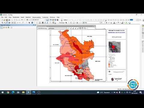
Cara Georeferencing Peta Menggunakan ArcGIS | #BelajarArcGIS #Part2
Summary
TLDRIn this tutorial, the presenter walks through the process of geo-referencing a geological map using ArcGIS. Geo-referencing is crucial for aligning maps with real-world coordinates. The speaker demonstrates how to add control points, select the correct coordinate system (WGS 1984), and input coordinates manually. They also explain how to check for RMS error to ensure accuracy. The video concludes with a demonstration on updating the map’s reference or creating a new rectified map. This tutorial is perfect for beginners looking to understand how to apply geo-referencing to maps for spatial analysis.
Takeaways
- 😀 Georeferencing in ArcGIS helps assign coordinates to maps without a coordinate system, aligning them with real-world locations.
- 😀 The tutorial is ideal for beginners learning GIS and map creation, providing a fundamental step for creating accurate maps.
- 😀 Georeferencing involves aligning a map with real-world coordinates by setting control points at known locations on the map.
- 😀 ArcGIS uses georeferencing tools to map geological sheets, including various regions of Indonesia, available for download.
- 😀 Control points are added by selecting the location on the map and inputting real-world coordinate values (latitude, longitude).
- 😀 The correct coordinate system for georeferencing is critical, with the tutorial using geographic coordinates in the WGS 1984 format.
- 😀 The tutorial demonstrates the process of adding control points using both 'input X and Y' and the DMS (degrees, minutes, seconds) format.
- 😀 Accuracy is important in georeferencing, and the RMS error value should be below 1 (preferably closer to 0.9) for better precision.
- 😀 Georeferencing tools in ArcGIS allow users to modify and update maps, with options for reactivating or updating georeference settings.
- 😀 After georeferencing, users can save the map with a defined coordinate system (e.g., TIFF format) for use in other GIS operations.
- 😀 The tutorial emphasizes that users can continue digitizing the map once georeferencing is completed, making it ready for analysis and further mapping tasks.
Q & A
What is georeferencing and why is it important?
-Georeferencing is the process of assigning spatial coordinates to a map or image that lacks them. It ensures that the map or image aligns with real-world locations, making it useful for analysis, comparison, or integration with other geographic data.
How does georeferencing benefit map creation?
-Georeferencing adjusts a map to real-world locations, enabling it to accurately reflect geographic coordinates. This process is essential for creating maps that are consistent with actual geographic locations and can be used in further spatial analysis or decision-making.
What is the first step in performing georeferencing in the Argus application?
-The first step is opening the Argus application and adding the map data. This could be a geological map from sources like the Indonesian Ministry of Energy and Mineral Resources (ESDM), which is often used for such tasks.
What is the significance of setting the correct coordinate system during georeferencing?
-Setting the correct coordinate system is crucial because it ensures the map's alignment with geographic locations. In the tutorial, the geographical coordinate system (e.g., WGS 1984) is used, which supports the input of coordinates in degrees, minutes, and seconds (DMS).
How do you add control points in Argus for georeferencing?
-To add control points in Argus, right-click on the map where you want to place a point and select 'Add Control Point.' You then input the coordinates (longitude and latitude) to align the map with real-world locations.
What does RMS error indicate in georeferencing, and what is its acceptable range?
-RMS error (Root Mean Square error) measures the accuracy of the control points placed on the map. A lower RMS error indicates better alignment. An acceptable RMS error is generally below 1, with values like 0.007 being ideal.
What is the difference between updating georeferencing and rectifying a map in Argus?
-Updating georeferencing adjusts the map to match the coordinates and adds the correct spatial reference to the original map. Rectifying, on the other hand, creates a new map with a different format, often involving a transformation of the original image into a spatially accurate map.
Why is it important to choose a high-quality image format like TIFF when saving a georeferenced map?
-TIFF is a high-quality image format commonly used for georeferencing because it preserves the image's details and quality, making it more suitable for geographic analysis and ensuring better accuracy when the map is used in GIS software.
How can you check if the georeferencing process was successful in Argus?
-After performing georeferencing, you can check the map's properties to verify the spatial reference system (e.g., WGS 1984) has been applied. If the coordinates and reference system are correctly displayed, the process has been successful.
What happens to the map data after the georeferencing process is completed?
-Once the georeferencing process is complete, the map will have spatial coordinates assigned to it. This makes it usable for further GIS analysis, such as creating shapefiles or performing spatial data operations.
Outlines

This section is available to paid users only. Please upgrade to access this part.
Upgrade NowMindmap

This section is available to paid users only. Please upgrade to access this part.
Upgrade NowKeywords

This section is available to paid users only. Please upgrade to access this part.
Upgrade NowHighlights

This section is available to paid users only. Please upgrade to access this part.
Upgrade NowTranscripts

This section is available to paid users only. Please upgrade to access this part.
Upgrade NowBrowse More Related Video

Georeferencing Dengan Arcgis

Registrasi Ulang Peta JPEG di ArcGis

TUTORIAL ATTACHMENT FOTO ARCGIS - mapvel geospatial

Membuat peta IUP menggunakan ArcMap - dengan data IUP MODI ESDM dan Titik Koordinat Dokumen IUP

Praktikum Sistem Informasi Geografi - Pembuatan Peta Kemiringan Lereng Demnas

Koreksi Geometri Peta - SIG
5.0 / 5 (0 votes)