Geografi Kelas X (6) Pengertian, Jenis dan Fungsi Peta
Summary
TLDRIn this geography lesson, the instructor introduces basic mapping concepts, including the definition, types, and functions of maps. The lesson covers key map types such as chorographic, topographic, and world maps, emphasizing scale differences and the use of contour lines. Special maps, like thematic maps for population density and tourism, are also explored. The lesson highlights the importance of maps in showing locations, distances, and various surface phenomena, ultimately helping users understand spatial information in real-world contexts.
Takeaways
- 😀 Maps are a representation of the Earth's surface, created on a flat plane, using reduced scales.
- 😀 Maps are not realistic images but are symbolic representations using various types of symbols like dots and lines.
- 😀 Maps can be classified into two main types: general maps (showing the entire Earth's surface) and special maps (focused on specific themes or regions).
- 😀 Chorographic maps depict large areas on a smaller scale, usually ranging from 1:250,000 to 1:1,000,000.
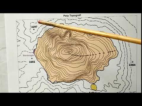
- 😀 Topographic maps display the Earth's relief using contour lines to indicate the height and depth of a region.
- 😀 A world map is an example of a small-scale general map that provides an overview of the Earth's surface.
- 😀 Special maps, or thematic maps, focus on specific themes like population density, land use, or tourism.
- 😀 Population density maps use color coding to show varying levels of density, providing clear visual information on human distribution.
- 😀 A cadastral map is a type of engineering map with a very large scale, typically ranging from 1:100 to 1:5,000.
- 😀 The primary functions of maps include showing locations, describing surface phenomena, measuring distances, and presenting spatial information for decision-making.
Q & A
What is the definition of a map according to Sutardjo Soerjono Sumarmo?
-A map is a painting with ink of all or part of the earth's settlements that are reduced by a comparison of sizes, called scales.
What does the national survey and mapping coordinating agency (Sultan Al Shop) say about the meaning of maps?
-According to the Sultan Al Shop, a map is a vehicle for storing and presenting environmental condition data, serving as a source of information for planners and decision makers at various stages of development.
How is a map conventionally represented?
-A map is a conventional depiction of the earth's surface on a flat plane, seen from above and reduced to a scale. It uses symbols such as dots and lines (e.g., rivers) to represent different features, which are not actual images but rather symbolic representations.
What are the two main types of maps?
-The two main types of maps are general maps and special maps.
What is a general map?
-A general map depicts everything on the earth's surface in a general way. Examples include chorographic maps, topographic maps, and world maps.
What is a chorographic map?
-A chorographic map depicts all or part of the earth's surface at a smaller scale, typically ranging from 1:250,000 to 1:1,000,000. It is used for showing geographical features at a broad level.
What is a topographic map?
-A topographic map shows the relief of the earth's surface with contour lines. These lines represent locations with equal elevation, helping to visualize the height and form of the terrain.
What is the difference between chorographic and topographic maps?
-The key difference is that chorographic maps depict large-scale geographical features with a smaller scale, while topographic maps use contour lines to show detailed terrain elevations, typically on a larger scale.
What is a special map or thematic map?
-A special or thematic map focuses on a specific theme, such as population density or land use, rather than depicting the general geography of an area. These maps are used for detailed information on particular subjects.
What are some functions of maps?
-Maps serve multiple functions, including showing the location of an area, describing the phenomena on the earth's surface, showing the size and distance of areas, and presenting spatial information like the location of cities, airports, and boundaries.
Outlines

This section is available to paid users only. Please upgrade to access this part.
Upgrade NowMindmap

This section is available to paid users only. Please upgrade to access this part.
Upgrade NowKeywords

This section is available to paid users only. Please upgrade to access this part.
Upgrade NowHighlights

This section is available to paid users only. Please upgrade to access this part.
Upgrade NowTranscripts

This section is available to paid users only. Please upgrade to access this part.
Upgrade NowBrowse More Related Video
Pengetahuan Dasar Peta #part 1

IPS kelas 7 bab 1a - Apa itu peta
Belajar Bersama, Bab 2 Dasar-dasar Pemetaan, Penginderaan Jauh dan Sistem Informasi Geografi Kelas X

Distributional Maps | Std 9 | Geography | Chapter 1 | Maharashtra Board
RANGKUMAN METERI GEOGRAFI KELAS X SMA SEMESTER 1 KURIKULUM MERDEKA
Pengertian, Jenis, dan Grafik Fungsi Trigonometri (Matematika Peminatan Kelas XI BAB I Part I)
5.0 / 5 (0 votes)