SISTEM INFORMASI GEOGRAFIS (SIG) LENGKAP
Summary
TLDRThis video provides an introduction to Geographic Information Systems (GIS), explaining its purpose as a computer-based system used to store, manipulate, and analyze geographic information. It covers the types of data involved in GIS, including spatial and attribute data, and describes the workflow of GIS from data input to processing and output, which results in maps. The video also outlines the components of GIS, such as hardware, software, data, and skilled personnel, and highlights its applications in natural resource management and urban planning. The video concludes with a summary of GIS's role in problem-solving using geographic data.
Takeaways
- 🌏 **Geographic Information System (GIS)**: The script discusses the concept of GIS, a computer-based system for storing, manipulating, and analyzing geographical information.
- 📊 **Data Types in GIS**: It highlights two types of data used in GIS - attribute data (descriptive information about locations) and spatial data (representing locations or areas on the Earth's surface).
- 🗺️ **Spatial Data Representation**: Spatial data can be presented in raster (grid-like) or vector (points, lines, polygons) formats.
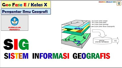
- 🔍 **GIS Workflow**: The script outlines the workflow of GIS, which includes inputting data, processing it, and then outputting it, typically in the form of maps.
- 📚 **Data Sources**: It mentions that data for GIS can come from various sources such as field research, government offices, maps, and remote sensing imagery.
- 🛠️ **Data Processing in GIS**: The script explains that GIS can perform functions to manipulate and analyze stored data, mentioning three types of analysis: raster analysis, arithmetic analysis, and network analysis.
- 📈 **Analyses in GIS**: It describes specific types of analyses such as overlay analysis for creating new classifications and network analysis for determining regions or areas within a certain radius.
- 📊 **Output from GIS**: The output from GIS, which can be used for decision-making, is mentioned to be in the form of maps, printouts, digital records, and displays.
- 💻 **Components of GIS**: The script lists the components needed for GIS to work, including hardware (like computers and printers), software (various programs), geographic data and information, and management (skilled human resources).
- 🌐 **Applications of GIS**: It concludes by stating that GIS is now applied not only in natural resource management but also in various fields of planning and development, aiding in problem-solving with data management.
Q & A
What is the full form of SIG?
-SIG stands for Sistem Informasi Geografis, which translates to Geographic Information System in English.
What is the primary function of a SIG?
-A SIG is used to store, manipulate, and analyze geographic information using computer systems.
What are the two types of data used in SIG?
-The two types of data used in SIG are data atribut (attribute data) and data spasial (spatial data).
What does attribute data represent in SIG?
-Attribute data represents information about a feature or location, such as forests, fields, and cities.
How is spatial data presented in SIG?
-Spatial data is presented in two forms or models: raster (grid) and vector (points).
What is the first step in the SIG workflow?
-The first step in the SIG workflow is inputting data, which can come from various sources like field research, government offices, maps, and remote sensing imagery.
What are the three types of analysis that can be performed in SIG?
-The three types of analysis in SIG are raster analysis, arithmetic analysis, and network analysis.
What is the purpose of output in SIG?
-The output in SIG provides analyzed data to users, which can be used as a basis for decision-making and is presented as maps, printouts, or displays.
What are the components required for SIG to function?
-The components required for SIG to function include hardware (like a complete computer system with CPU, plotter, or printer), software (modules like info cardview, arjis, etc.), geographic data and information (spatial data, aerial photos, satellite images, and attribute data), and management (human resources with expertise in processing GIS).
How is SIG applied in various fields?
-SIG is applied not only in natural resource management but also in planning and development fields, helping to solve problems and manage various data with the aid of computer technology.
What can be concluded about the use of SIG in handling data?
-It can be concluded that with SIG, data can be processed and transformed into maps that are needed for various applications.
Outlines

This section is available to paid users only. Please upgrade to access this part.
Upgrade NowMindmap

This section is available to paid users only. Please upgrade to access this part.
Upgrade NowKeywords

This section is available to paid users only. Please upgrade to access this part.
Upgrade NowHighlights

This section is available to paid users only. Please upgrade to access this part.
Upgrade NowTranscripts

This section is available to paid users only. Please upgrade to access this part.
Upgrade Now


5.0 / 5 (0 votes)