01 - Introdução ao Geoprocessamento
Summary
TLDRThis video introduces the concepts of geoprocessing and geographic information systems (GIS), explaining their application through the historical example of the 1854 London cholera epidemic. Geoprocessing is a set of techniques used to collect, analyze, and visualize spatial data for decision-making in various fields such as environmental monitoring, urban planning, and agriculture. The role of GIS is to manipulate and analyze georeferenced data, supporting informed decisions with the help of technology and human resources. The video emphasizes the importance of spatial analysis in addressing real-world problems and highlights the tools available for modern geoprocessing tasks.
Takeaways
- 😀 Geoprocessing is the practice of making decisions based on spatial analysis and georeferenced data.
- 😀 One of the earliest examples of spatial analysis was Dr. John Snow's cholera investigation in London in 1854, which used a map to identify the source of the epidemic.
- 😀 Geoprocessing techniques allow for large-scale analysis of spatial data, aiding decision-making in fields like public health, environmental monitoring, and urban planning.
- 😀 To work with geoprocessing, data must be georeferenced, meaning it has known coordinates (latitude, longitude, altitude).
- 😀 Georeferenced data can be collected through methods such as remote sensing, GPS, satellite images, and traditional maps.
- 😀 Spatial analysis can be used in various fields such as deforestation monitoring, precision agriculture, and urban planning.
- 😀 Geoprocessing helps to answer questions like 'where' something is happening, making it an essential tool for addressing location-based issues.
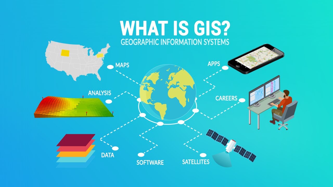
- 😀 Geographic Information Systems (GIS) are the tools used to manipulate, visualize, and analyze georeferenced data in spatial analysis.
- 😀 GIS requires appropriate hardware, such as computers with good processing power and storage, to handle the data effectively.
- 😀 Different methodologies are applied in GIS depending on the objectives, such as land-use analysis or environmental monitoring.
- 😀 Ultimately, geoprocessing and GIS support decision-making by helping to visualize and analyze spatial data, guiding actions in various sectors.
Q & A
What is geoprocessing?
-Geoprocessing is a set of techniques used to collect, store, analyze, and integrate spatial data. It helps in making informed decisions based on spatial analysis.
What was the example of spatial analysis mentioned in the script?
-The example discussed a cholera epidemic in London in 1854. Dr. John Snow used a map to superimpose the locations of cholera cases and water wells, leading to the identification of a contaminated well, which helped contain the epidemic.
How did Dr. John Snow's decision-making illustrate the concept of geoprocessing?
-Dr. Snow used spatial analysis by mapping cholera cases and water wells, identifying a correlation that led to the decision to seal a contaminated well. This is an early example of geoprocessing supporting a decision based on spatial data.
Why is georeferencing important in geoprocessing?
-Georeferencing is essential because it assigns a known geographic location (coordinates) to data. This allows for accurate spatial analysis and helps in making informed decisions based on the location of the data.
What kinds of data collection methods are used in geoprocessing?
-Geoprocessing uses various data collection methods such as remote sensing (satellite and drone imagery), topography, GPS, and traditional cartography (maps).
What role does GIS (Geographic Information System) play in geoprocessing?
-GIS is a system that integrates software, hardware, and human resources to collect, store, retrieve, visualize, and analyze spatial data. It supports decision-making by enabling spatial analysis of georeferenced data.
How has geoprocessing evolved since the 1854 cholera epidemic example?
-Geoprocessing has evolved with advances in technology, allowing for the handling of larger datasets, more complex spatial analyses, and the use of more sophisticated tools like GIS software for decision support.
Can you give examples of how geoprocessing is used today?
-Geoprocessing is used in various fields, such as monitoring deforestation using satellite images, urban planning, and precision agriculture for creating variable-rate application maps.
What is the relationship between GIS and spatial data?
-GIS helps manipulate, visualize, and analyze spatially referenced data, which has specific geographic coordinates. It enables users to make decisions based on the spatial relationships within the data.
Why is it necessary to use appropriate hardware and software in geoprocessing?
-To work efficiently with large datasets and perform spatial analysis, geoprocessing requires robust hardware (with good processing capacity and storage) and appropriate software tools for handling and analyzing georeferenced data.
Outlines

This section is available to paid users only. Please upgrade to access this part.
Upgrade NowMindmap

This section is available to paid users only. Please upgrade to access this part.
Upgrade NowKeywords

This section is available to paid users only. Please upgrade to access this part.
Upgrade NowHighlights

This section is available to paid users only. Please upgrade to access this part.
Upgrade NowTranscripts

This section is available to paid users only. Please upgrade to access this part.
Upgrade NowBrowse More Related Video


5.0 / 5 (0 votes)