[TUTORIAL 1] DASAR MENGGUNAKAN TOTAL STATION TOPCON GM-101 SERIES | ANAK TEKNIK
Summary
TLDRThis video tutorial explains how to use a total station for surveying tasks. Starting with unboxing the equipment, the video walks through turning on the device, setting up without a tripod, and configuring the instrument for precise measurements. It demonstrates setting up jobs, inputting coordinates, and adjusting settings such as azimuth and height. The presenter emphasizes accuracy during fieldwork, offering a step-by-step guide for topographic measurements. The video also highlights configuring various data modes like angle, distance, and coordinate data, ensuring users can capture accurate survey results efficiently.
Takeaways
- 🔌 The first step in using the Total Station is to power it on by pressing the power button on the bottom right corner.
- 🛠️ If using a tripod, it's crucial to adjust the tripod and the Total Station's leveling bubble to ensure accurate measurements.
- 🎯 The device's crosshair must be positioned precisely, with a recommended precision of less than one second for accurate readings.
- 📋 In the field, make sure to maintain high accuracy, ideally achieving zero or minimal error for data collection.
- 🔍 The configuration menu allows the user to set various options like observation conditions, distance measurement modes, and angles.
- 💾 Data can be downloaded using the USB menu, and job data can be managed under the configuration settings.
- 📐 Users can set observation modes like vertical distance and height of the instrument, which can be tailored based on the task.
- 📝 To start a job, users need to create or select a job from the available list and input required details like coordinates and instrument height.
- 🌍 The device can work with both local and global coordinates, allowing flexibility depending on the project requirements.
- 🧭 The Total Station can measure angles and distances based on either known coordinates or azimuths, which can be aligned using a compass for directional accuracy.
Q & A
What is the first step when using the total station device?
-The first step is to power on the device by pressing the power button located on the right side of the device.
Why is using a tripod recommended when operating the total station?
-Using a tripod ensures the device is stable and allows for accurate leveling, which is essential for precise measurements. It helps avoid any shaking or movement during the survey.
How do you adjust the leveling of the total station?
-To adjust the leveling, you can use the screws on the base of the device to position the leveling bubble in the center of the circle on the screen.
What does the 'Escape' button do during the setup process?
-The 'Escape' button is used to exit the current screen or setting and return to the main menu where you can adjust settings like cutting adjustments or start observations.
How can you ensure precise angle settings during measurements?
-For precise angle settings, it is recommended to aim for a reading below one second of accuracy. The device should be calibrated carefully, especially when using a tripod.
What is the purpose of the 'Observation Condition' settings?
-The 'Observation Condition' settings allow the user to configure parameters like angle, distance, reflector settings, and atmospheric conditions for more accurate measurements.
How can you create or select a new job for data collection?
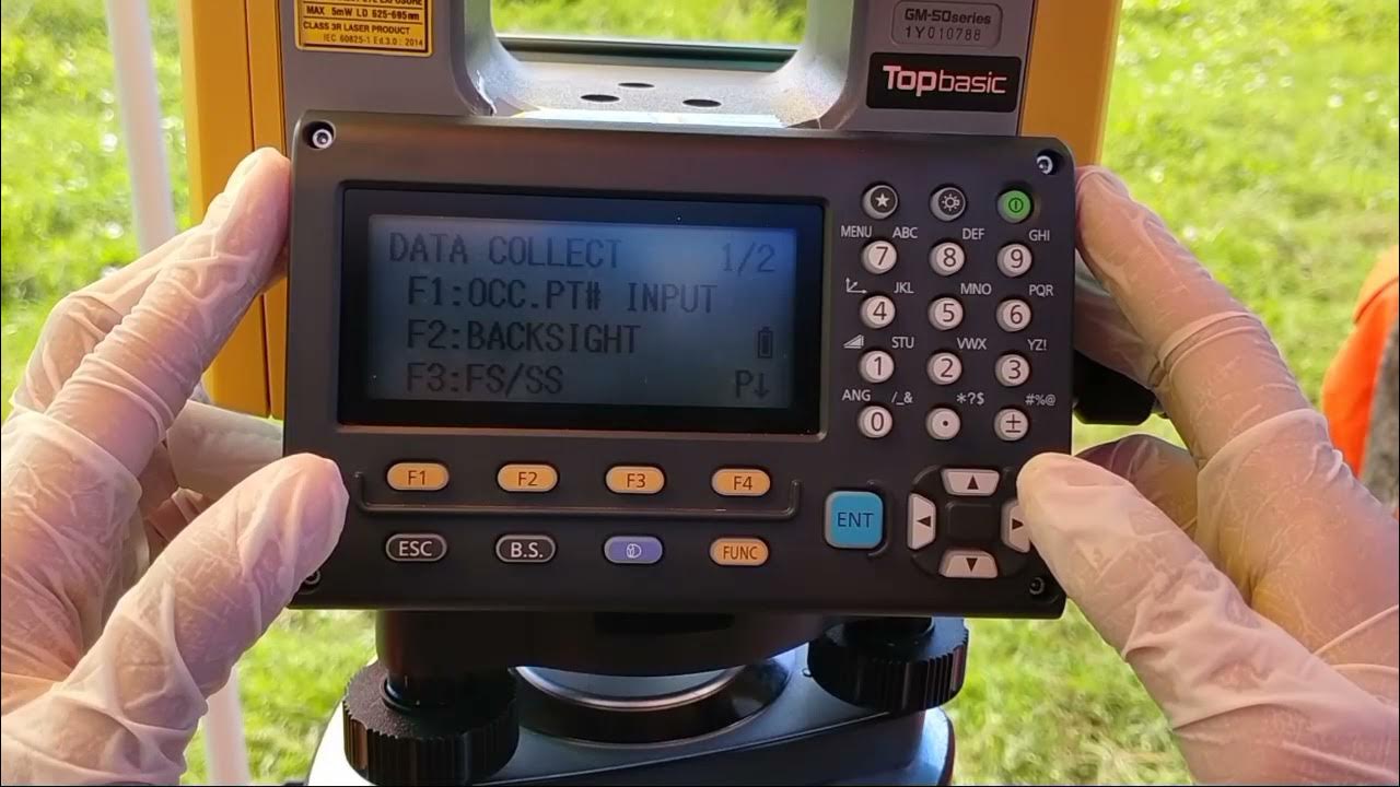
-To create or select a job, navigate to the 'Job Selection' menu, choose 'New Job,' name the job, and set the necessary parameters, such as coordinates and scaling.
What is the role of the 'F4' button during configuration?
-The 'F4' button is used to enter configuration settings, such as adjusting observation conditions, configuring the device, and preparing it for data collection.
How do you input the coordinates when setting up the device for measurements?
-Coordinates can be entered manually if known, or local coordinates can be used, such as 1000, 1000, and 100 for the X, Y, and Z values if no external data is available.
How do you set up the orientation of the total station for topographic measurements?
-To set up the orientation, point the device in the direction of true north using a compass, and adjust the horizontal angle to zero using the fine adjustment screws.
Outlines

This section is available to paid users only. Please upgrade to access this part.
Upgrade NowMindmap

This section is available to paid users only. Please upgrade to access this part.
Upgrade NowKeywords

This section is available to paid users only. Please upgrade to access this part.
Upgrade NowHighlights

This section is available to paid users only. Please upgrade to access this part.
Upgrade NowTranscripts

This section is available to paid users only. Please upgrade to access this part.
Upgrade NowBrowse More Related Video

TUTORIAL PENGOPRASIAN TOTAL STATION LEICA TS06 INDONESIA

Cara Pematokan (Stake Out) dengan Alat Total Station Topcon GM-55

TOTAL STATION : Si Kuning Alat Ukur

Cara Pengukuran Detail Situasi dengan Alat Total Station Topcon GM-55

Tutorial Set Up Total Station Leica TS16 R1000 Dengan Leica Captivate V.7.0

How to setup RTK on Mavic 3E, M300, & M350 with Emlid RS2/RS3 and NO internet. 4 Different Scenarios
5.0 / 5 (0 votes)