Plane Sailing - Part 1: Course is less than 90 degrees (Tagalog)
Summary
TLDRThis tutorial explains how to apply trigonometric principles to sailing navigation, focusing on calculating departure, latitude differences, and course using sine, cosine, and tangent. The speaker demonstrates how to solve problems by breaking down the calculations into clear steps, including how to determine the distance covered and the angle of course based on nautical miles and degrees. The use of a calculator for accurate computation is emphasized, with real-life examples illustrating how to calculate departure and latitude differences for a sailing ship.
Takeaways
- 😀 Departure and difference in latitude are key concepts in calculating the position of a ship in navigation.
- 😀 Trigonometric ratios such as sine and cosine are used to calculate departure and latitude differences.
- 😀 Departure is the east-west distance, and difference in latitude is the north-south distance between two points.
- 😀 The sine of the course angle helps in calculating the departure distance traveled by the ship.
- 😀 The cosine of the course angle helps in calculating the difference in latitude covered by the ship.
- 😀 In the first example, a ship sails at a course of 53° for 74 nautical miles, resulting in a departure of 59 nautical miles and a latitude difference of 45 nautical miles.
- 😀 The second example demonstrates how to calculate the distance traveled and course angle when the departure and latitude difference are known.
- 😀 The distance traveled can be calculated using the Pythagorean theorem: √(departure² + latitude difference²).
- 😀 The course is found by using the inverse tangent function: inverse tan(departure / latitude difference).
- 😀 In the second example, the course angle is approximately 34.3° (between 90° and 180°) based on the departure and latitude difference values.
Q & A
What is the main concept introduced in the video?
-The video focuses on calculating the distance and direction when sailing, specifically using trigonometric functions like sine and cosine to determine departure and latitude differences.
What is the relationship between latitude differences and distance in the context of the video?
-The distance between two points in latitude is related to the difference in latitudes, with the difference in latitudes being directly used to calculate the departure (distance) from one point to another.
How is the departure calculated in the video?
-Departure is calculated using the sine of the course angle (53 degrees in the example) multiplied by the distance traveled (74 nautical miles), giving a value of 59 nautical miles.
What trigonometric ratio is used to calculate departure and latitude difference?
-Sine is used to calculate the departure, and cosine is used to calculate the difference in latitude.
What does 'cosine of 53 degrees' represent in the context of the example?
-The cosine of 53 degrees is used to calculate the difference in latitude, which is the adjacent side of the triangle formed by the ship's course, distance, and latitude difference.
What does the term 'hypotenuse' refer to in the calculations?
-The hypotenuse refers to the total distance traveled by the ship (74 nautical miles in the example) along the course, which is the longest side of the triangle.
In the example problem, how is the departure of the ship determined?
-The departure is calculated by multiplying the distance traveled (74 nautical miles) by the sine of the course angle (53 degrees), resulting in 59 nautical miles.
How is the difference in latitude calculated in the example?
-The difference in latitude is determined by multiplying the distance traveled (74 nautical miles) by the cosine of the course angle (53 degrees), resulting in a value of 45 nautical miles.
What is the purpose of the inverse tangent (arctan) function in the problem?
-The inverse tangent (arctan) function is used to calculate the course angle when the departure and latitude difference are known. It helps to determine the angle from the ship's position relative to the North-South line.
What is the significance of the course in the second example with a departure of 43 nautical miles?
-The course in the second example is calculated by using the inverse tangent of the ratio of departure (43 nautical miles) to latitude difference (62 nautical miles), which helps to find the direction of the ship's travel.
Outlines

Cette section est réservée aux utilisateurs payants. Améliorez votre compte pour accéder à cette section.
Améliorer maintenantMindmap

Cette section est réservée aux utilisateurs payants. Améliorez votre compte pour accéder à cette section.
Améliorer maintenantKeywords

Cette section est réservée aux utilisateurs payants. Améliorez votre compte pour accéder à cette section.
Améliorer maintenantHighlights

Cette section est réservée aux utilisateurs payants. Améliorez votre compte pour accéder à cette section.
Améliorer maintenantTranscripts

Cette section est réservée aux utilisateurs payants. Améliorez votre compte pour accéder à cette section.
Améliorer maintenantVoir Plus de Vidéos Connexes
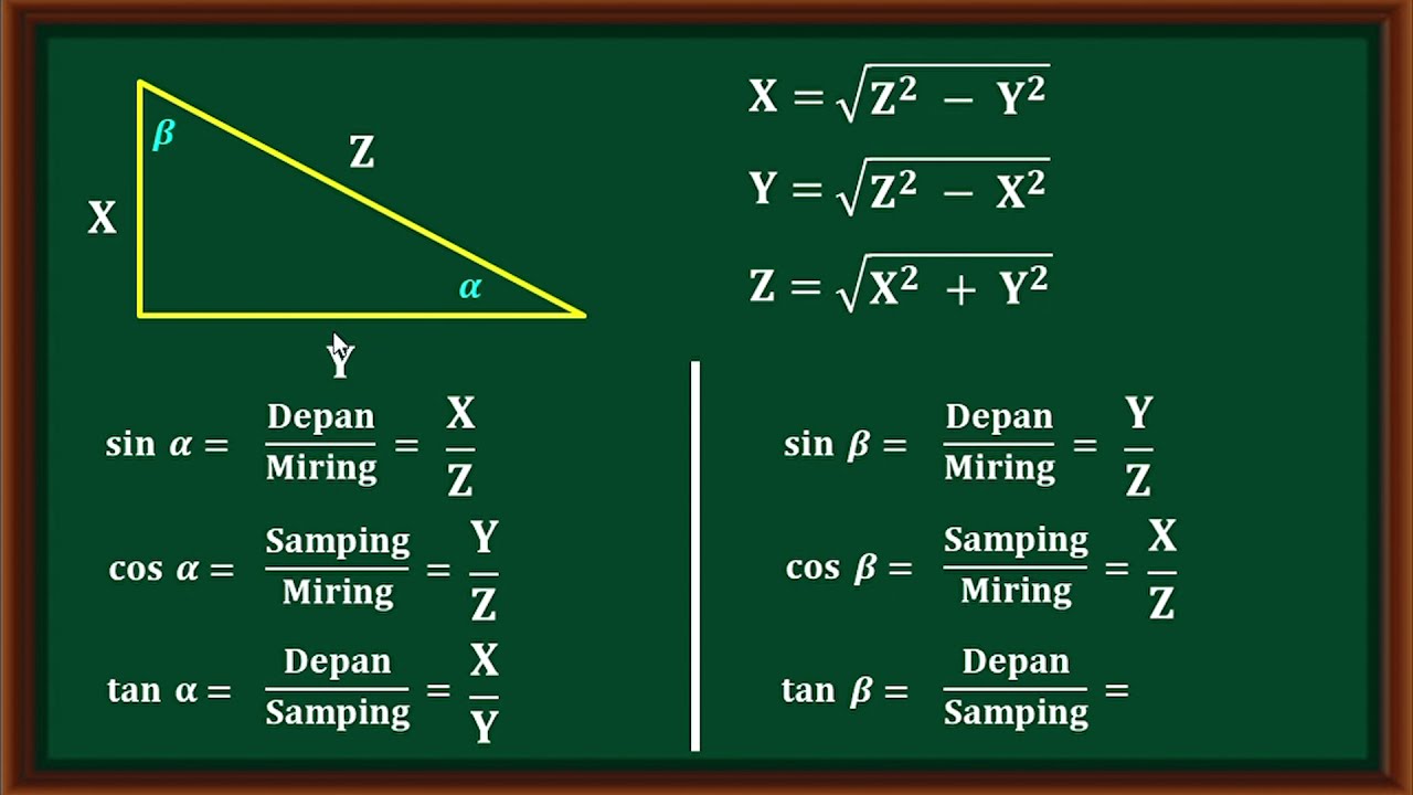
Materi dan soal pembahasan Perbandingan trigonometri dari suatu sudut pada segitiga siku-siku.
Turunan Fungsi Trigonometri 4: Turunan Kedua Fungsi Trigonometri

Contoh Soal Perbandingan Trigonometri pada segitiga siku siku

[Math 20] Lec 3.4 Fundamental Identities (1 of 2)

Menentukan Nilai Trigonometri Segitiga Siku Siku Perbandingan Trigonometri segitiga Siku Siku

Media Pembelajaran Trigonometri || Jari Trigonometri (Jargonometri)
5.0 / 5 (0 votes)
