COME LEGGERE IL RADAR E DIFENDERSI DALLA GRANDINE!
Summary
TLDRThis video educates viewers on how to predict and prepare for storms in Italy using weather radar. It explains how radar works, how to read radar images to identify storm intensity, and how to track storm movement. The video highlights the dangers of severe weather like hail and tornadoes and provides practical advice on how to stay safe, whether you're driving or at home. It also recommends apps like Windy and websites for storm tracking, empowering viewers with the knowledge to protect themselves and their property from the increasing impact of climate change.
Takeaways
- 😀 Storms in Italy are becoming increasingly intense, partly due to global warming.
- 🌩️ Hailstones can reach dangerous sizes, with a record-breaking 20 cm hailstone in northern Italy in 2023.
- 📡 Weather radar is a powerful tool for predicting storms and hail, helping people anticipate severe weather.
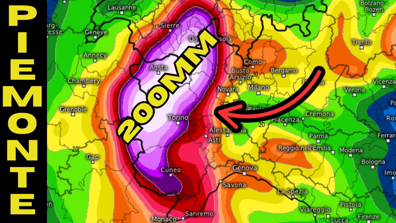
- 🌧️ Radar images use a color scale to show the intensity of precipitation, ranging from blue (light rain) to violet (heavy hail).
- 🚗 By using radar, people can determine storm movement, direction, and speed, allowing them to make timely decisions for safety.
- ⏱️ Radar updates every 5, 10, 15, or 30 minutes to provide real-time information on storm progression.
- 🔄 Single-cell and multicell storms follow the wind direction, but supercells are more unpredictable and dangerous, often linked to tornadoes.
- 🌀 A special radar feature, the Hook echo, indicates the presence of a tornado, which often forms in the most intense part of a storm.
- 🚧 When driving during severe storms, avoid areas where radar shows dense precipitation or a tornado’s path, and stop in a safe place if necessary.
- 🏠 At home, take precautions by securing outdoor items and staying away from windows and doors, as tornadoes can be hidden in rain.
- 📱 Windy is a highly recommended app for monitoring weather patterns, covering Italy and the Mediterranean region, with other useful resources like Civil Protection and Meteo Radar also available.
Q & A
What role does radar play in storm prediction?
-Radar helps predict storms by emitting electromagnetic waves that bounce back when they hit precipitation particles. This allows us to estimate the storm's intensity, movement, and direction, helping us prepare for dangerous weather conditions like hail and tornadoes.
How can we interpret the intensity of precipitation on radar images?
-Radar images use a color scale to depict precipitation intensity. Blue indicates light precipitation, green shows moderate rain, yellow represents heavy precipitation, red indicates intense rain with a possibility of hail, and purple suggests very heavy precipitation with large hail.
What is the significance of the 'hook echo' in a radar image?
-The hook echo is a distinctive feature in radar images that appears as a small curl or hook shape. It indicates the most dangerous part of a storm, often associated with the potential for tornado formation.
What are the main differences between single cells, multicells, and supercells in storm prediction?
-Single and multicell storms typically follow the direction of the prevailing wind, making them easier to predict. Supercells, however, feature rotating updrafts (mesocyclones) and can shift directions, making them harder to track and more dangerous due to the potential for tornadoes.
How does global warming contribute to the increasing intensity of storms?
-Global warming raises the temperature of the atmosphere, allowing more energy to be available for storm formation. This results in stronger and more violent storms, as we’ve seen with increasing occurrences of intense weather events like hailstorms in recent years.
What should you do if you encounter a storm while driving?
-If you're in a car and a storm is approaching, avoid the center of the storm or the heaviest precipitation. It’s safest to stop in a secure location, avoiding bridges or overpasses. Always ensure you're not driving into a potential tornado or hailstorm.
Why is it important to be informed about storm movements, especially with radar tools?
-Being informed about storm movements allows you to take proactive steps, such as changing your route or securing your property. Radar tools show how storms move, how fast they are approaching, and whether you’ll be directly impacted or if it will miss you.
Can tornadoes be difficult to detect on radar images? Why?
-Yes, tornadoes can be difficult to detect on radar images because they are sometimes wrapped in rain, making them invisible or harder to spot. This makes it crucial to monitor radar images carefully and take safety precautions when storms are nearby.
What are the key radar tools recommended for storm tracking in Italy?
-The key radar tools recommended include the **Windy** app, which covers the entire Mediterranean region, including Italy. Other useful resources are the Civil Protection website, **Meteo Radar**, and **YouMeteo**, which also offer radar images and weather forecasts.
What safety measures should be taken at home before a storm arrives?
-Before a storm arrives, secure any loose items outside, move valuables away from windows and doors, and take shelter in a safe area of the home. If there's enough time, prepare your property to minimize potential damage. Always prioritize personal safety first.
Outlines

Esta sección está disponible solo para usuarios con suscripción. Por favor, mejora tu plan para acceder a esta parte.
Mejorar ahoraMindmap

Esta sección está disponible solo para usuarios con suscripción. Por favor, mejora tu plan para acceder a esta parte.
Mejorar ahoraKeywords

Esta sección está disponible solo para usuarios con suscripción. Por favor, mejora tu plan para acceder a esta parte.
Mejorar ahoraHighlights

Esta sección está disponible solo para usuarios con suscripción. Por favor, mejora tu plan para acceder a esta parte.
Mejorar ahoraTranscripts

Esta sección está disponible solo para usuarios con suscripción. Por favor, mejora tu plan para acceder a esta parte.
Mejorar ahoraVer Más Videos Relacionados

ATPL Radio Navigation - Class 10: Weather Radar.
MASSIMA ATTENZIONE IN PIEMONTE! SITUAZIONE CRITICA! (17/04/25)
Quali Eventi Estremi sono dovuti al Cambiamento Climatico? (e quali no?)

Wie entsteht eine Wettervorhersage?

NASA | Supercomputing the Climate

Weather, Air Masses, Lifting and Midlatitude Cyclones
5.0 / 5 (0 votes)
