QGIS | Tutorial Membuat Peta Dengan Mudah Menggunakan QGIS v 3.28 Tahun 2024
Summary
TLDRThis video tutorial provides a step-by-step guide on creating a map using the QGIS application (version 3.28). The process begins by setting up Google Earth as a basemap, followed by importing and visualizing shapefiles of Indonesia's regional subdivisions. The tutorial walks viewers through filtering and styling sub-districts in the city of Bogor, customizing color schemes, labels, and adding essential map elements such as grids, scale, and legend. The final steps include formatting and saving the map, with helpful tips on adjusting layout, adding text, and incorporating logos. Ideal for anyone looking to design detailed maps in QGIS.
Takeaways
- 😀 Ensure your device is connected to the internet and you have SHP files and a basemap before starting the map creation process in QGIS.
- 😀 Use Google Earth Satellite as your basemap by manually adding it through a URL if it doesn't appear in QGIS by default.
- 😀 Download and prepare SHP files for the regional map you want to use (such as sub-districts in Indonesia).
- 😀 Filter the sub-district data in the attribute table by using the name field to focus on the specific area you want to map (e.g., Bogor).
- 😀 Use 'Categorical' symbology to assign random colors to each sub-district for easy differentiation.
- 😀 Label each sub-district with its name by editing the 'Label' properties and adjusting the font and size.
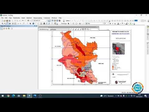
- 😀 Create a layout for your map by selecting 'New Print Layout' and adding the map to the layout window.
- 😀 Adjust the map's zoom level, grid, and scale for clarity, using the 'Grid' properties for intervals and units.
- 😀 Add a title to the map (e.g., 'Sub-District Map in Bogor City, 2024') and format it using the font and size options.
- 😀 Insert a scale bar and wind direction arrows to enhance map readability and add contextual information.
- 😀 Export the completed map as an image or PDF file to save it for sharing or printing.
Q & A
What is the first step in creating a map in QGIS 3.28?
-The first step is to make sure your computer is connected to the internet, and you have a shapefile (SHP) and a basemap (like Google Earth Satellite) ready.
How do you add Google Earth Satellite as a basemap in QGIS?
-To add Google Earth Satellite, go to the Project menu, select Templates, and scroll to the browser section. If Google Earth doesn't appear, right-click to add a new connection, paste the URL provided, and click OK.
Where can you find the shapefile (SHP) data for regional maps in Indonesia?
-You can download shapefiles for regional maps in Indonesia (such as sub-districts, provinces, and cities) through a browser or Google search.
How can you filter to show only the sub-districts in Bogor?
-Right-click the shapefile layer, open the attribute table, and search for the city of Bogor. You can filter the data by using the field 'name 2' and selecting the Bogor city value.
How can you apply different colors to each sub-district on the map?
-To apply different colors, right-click the shapefile layer, select 'Properties', go to the symbology section, and change the symbology to 'Categorical'. Then, select 'name 3' for sub-districts and choose random colors.
What is the purpose of adding labels to the map?
-Labels are added to display the names of each sub-district on the map. You can edit the font style, size, and alignment for clear visibility.
How do you create a map layout in QGIS?
-To create a map layout, go to the Project menu, click 'New Print Layout', and then use 'Add Item' to add a map. You can resize and adjust it as necessary.
What is the role of grids and scale in a map layout?
-Grids and scale help provide reference points for the map. You can adjust the grid type, size, and interval, and set the scale to represent the map’s real-world dimensions.
How can you insert additional elements like text, logo, or wind direction on the map?
-To add elements like text, logos, or arrows, use the 'Add Item' section. You can select 'Text' for labels, 'Add Picture' for logos, and 'Add Arrow' for wind direction.
How do you save the final map created in QGIS?
-To save the map, go to the 'Layout' section and choose 'Export Image', 'Export SVG', or 'Export as PDF'. Select your desired format and save it to your device.
Outlines

此内容仅限付费用户访问。 请升级后访问。
立即升级Mindmap

此内容仅限付费用户访问。 请升级后访问。
立即升级Keywords

此内容仅限付费用户访问。 请升级后访问。
立即升级Highlights

此内容仅限付费用户访问。 请升级后访问。
立即升级Transcripts

此内容仅限付费用户访问。 请升级后访问。
立即升级浏览更多相关视频

Pembuatan Peta Administrasi Kabupaten Sidoarjo dengan QGIS | UAP MSDL Shif A

How to Create Map Animation like Dhruv Rathee | Vox | Johnny Harris in Geo Layers 3 Part 2 | EZEdit
Georeferencing Dengan Arcgis

12 Menit Tutorial Desain PCB Eagle 7.6.0
Tutorial Qgis | Cara Mendownload dan Menginstal Qgis | Terbaru 2022
How to install NetBeans IDE 18 on Windows 10/11 (64 bit) [ 2023 Update ] Complete Installation guide
5.0 / 5 (0 votes)
