Popy X 1 Dasar Pemetaan Indera SIG Geo X Regulasi Diri
Summary
TLDRThis presentation by Poppy Desmita Nainggolan explores the fundamentals of mapping, remote sensing, and geographic information systems (GIS). It defines maps as representations of Earth's surface, detailing their essential components, such as scale, legend, and projections. The functions of maps include indicating locations, describing physical and cultural characteristics, and providing data visualization. Remote sensing involves collecting information without direct contact, while GIS manages spatial data for specific applications. The discussion also addresses the criteria for creating effective maps and the types of geographic information available through maps, atlases, and globes.
Takeaways
- 😀 Maps have been essential tools for humans for over 4000 years, with the oldest known map originating from ancient Babylon.
- 🗺️ A map is defined as a representation of natural and artificial elements on a flat surface, utilizing projections and scales to depict the Earth's features.
- 🔍 The scale of a map is crucial, as it provides the ratio between distances on the map and actual distances on the ground.
- 📚 An atlas is a collection of maps compiled into a single book or media format, offering various geographic representations.
- 📐 Different types of map projections include zenithal, conic, and cylindrical, each serving specific purposes in representing the Earth's surface.
- 🏞️ Maps serve multiple functions, such as indicating locations, describing physical characteristics of regions, and showcasing demographic and cultural information.
- 📡 Remote sensing is the process of collecting information about objects or phenomena without direct contact, using specialized instruments.
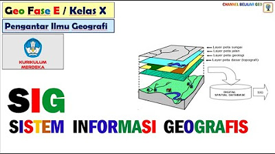
- 🌍 Geographic Information Systems (GIS) are essential for managing spatial data, facilitating tasks like collection, refinement, and visualization.
- 🔑 Important components of a map include the title, scale, legend, source, data inserts, orientation, and coordinates.
- 🧭 Geographic information can be found on maps, atlases, and globes, with each format providing unique insights, such as administrative indices and coordinate systems.
Q & A
What is the significance of maps in human exploration?
-Maps have been essential for exploration and understanding Earth's surface since ancient times, aiding in navigation and research of various regions.
How old is the oldest known map, and where was it found?
-The oldest known map dates back 4,000 years and was discovered in ancient Babylon.
What is a map?
-A map is a representation of natural and human-made features on Earth's surface depicted on a flat plane, created using specific projections and scales.
What are the main components of a map?
-Key components of a map include the title, scale, legend, source, data insertion, orientation, and coordinates.
What are the different types of map projections?
-Common types of map projections include zenithal, conical, and cylindrical projections.
What functions do maps serve?
-Maps serve various functions, including indicating locations, describing physical geography, and presenting social and cultural data.
What is remote sensing?
-Remote sensing is the process of acquiring information about objects or phenomena from a distance without direct contact, typically using specialized instruments.
What is a Geographic Information System (GIS)?
-GIS is a system designed for collecting, managing, and visualizing spatial data to meet specific analytical needs.
How can one formulate their definition of a map?
-One can define a map as a representation of Earth's surface on a flat plane that is created with particular projections and scales.
What are the requirements for creating a good map?
-Good maps must be equidistant, equivalent, conforming, and provide complete and easily readable information.
What geographic information can be found on maps, atlases, and globes?
-Maps can provide information such as titles, administrative numbers, and geographic coordinates, while atlases show types of maps and coordinate systems, and globes help determine locations and standard time zones.
Outlines

此内容仅限付费用户访问。 请升级后访问。
立即升级Mindmap

此内容仅限付费用户访问。 请升级后访问。
立即升级Keywords

此内容仅限付费用户访问。 请升级后访问。
立即升级Highlights

此内容仅限付费用户访问。 请升级后访问。
立即升级Transcripts

此内容仅限付费用户访问。 请升级后访问。
立即升级浏览更多相关视频

Pengolahan Citra Penginderaan Jauh untuk jaringan transportasi

Pengetahuan Peta, Pengindraan Jauh, dan Sistem Informasi Geografi (SIG) X SMA/MA

What is Remote Sensing and GIS?

G.I.S (Geographic Information Systems)- Concepts, Components, Advantages + Past Paper | Grade 10-12.

Penginderaan Jauh | Geografi | Alternatifa

Sistem Informasi Geografis # kurikulum merdeka.
5.0 / 5 (0 votes)
