Pengetahuan Peta, Pengindraan Jauh, dan Sistem Informasi Geografi (SIG) X SMA/MA

Dina Camelia
4 Sept 202113:24

Summary

TLDRThis educational video script introduces the basics of remote sensing and Geographic Information Systems (GIS). It explains the components of a map, such as titles, edges, and legends, and delves into remote sensing techniques that use sensors to capture information from a distance. The script also covers the interpretation of images, the significance of various features like color, shape, and texture, and how GIS systems integrate and process spatial data. It concludes with a call to action for viewers to apply their newfound knowledge.

Takeaways

  • 🌍 Maps are conventional representations of the Earth's surface, reduced in scale and viewed from above.
  • 🏷️ Key components of a map include the title, map edges, coordinates, legend, symbols, inserts, scale, orientation, and data sources and creation date.
  • πŸ“ The legend is crucial as it explains the symbols used on a map, while symbols represent features on the Earth's surface.
  • πŸ” Inserts show the location of the mapped area in relation to surrounding areas, helping to contextualize the main mapped region.
  • πŸ“ Scale on a map represents the ratio between distances on the map and actual distances on the Earth's surface.
  • 🧭 Orientation on a map indicates direction, typically using a north arrow to show the position and direction of a point or area.
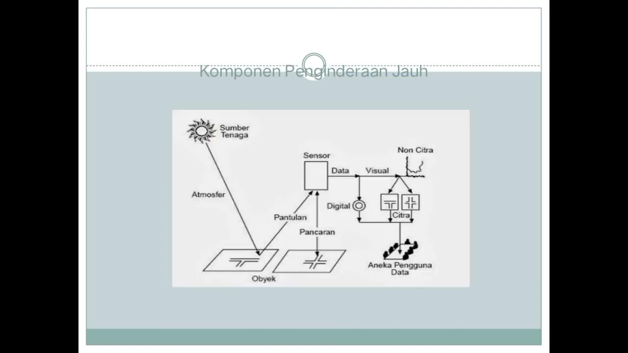
  • 🌐 Remote sensing is a technique to obtain information about objects from a distance without direct contact, using sensors to record reflected or emitted energy.
  • 🌞 In remote sensing, passive energy sources like sunlight are used, as opposed to active energy sources which emit their own energy.
  • πŸ›°οΈ Vehicles such as balloons, airplanes, reusable spacecraft, and satellites are used to place sensors for recording in remote sensing.
  • πŸ“Š Data acquisition in remote sensing can be done manually by interpreting aerial photos visually or numerically/digitally using computers.
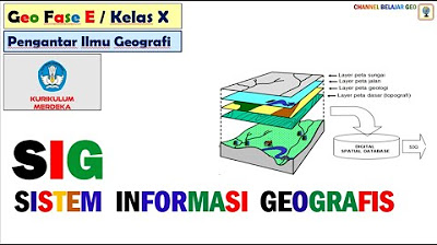
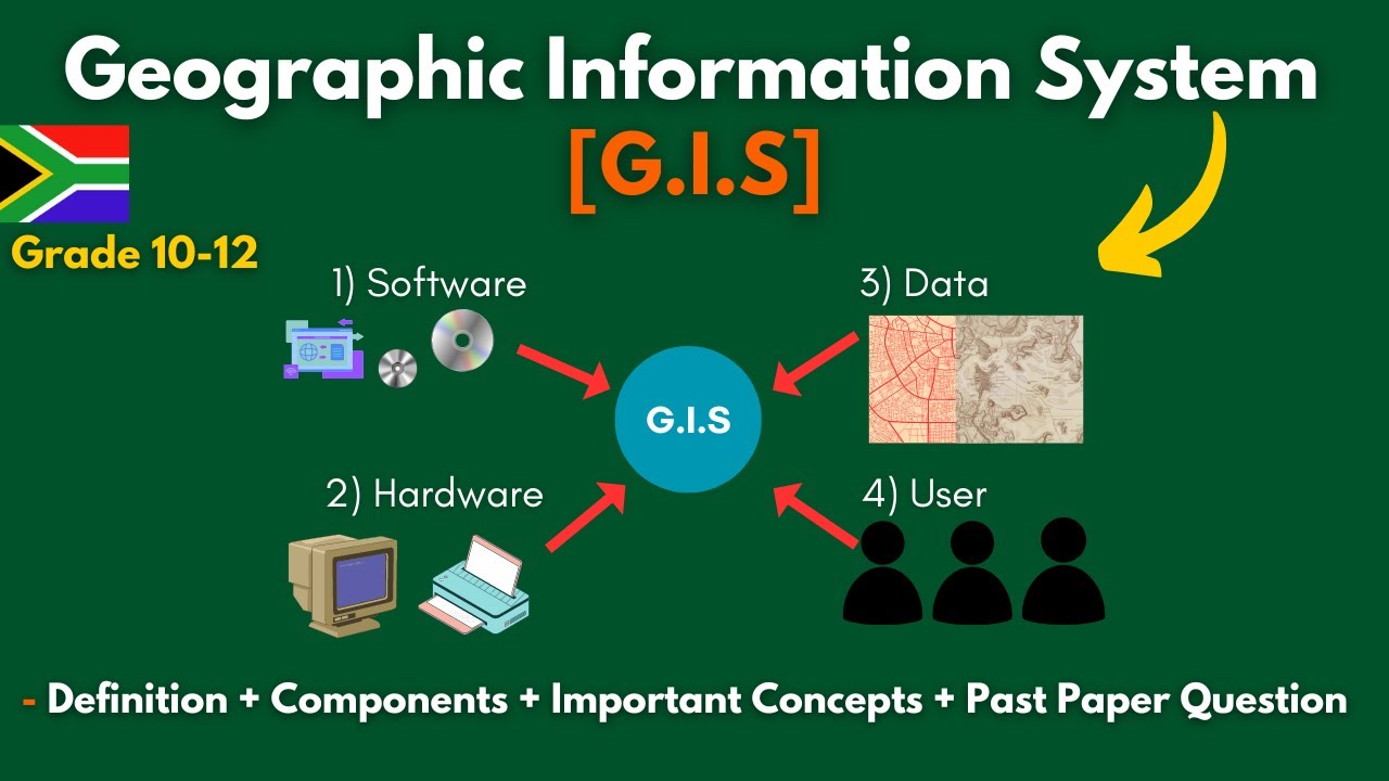
  • πŸ—ΊοΈ A Geographic Information System (GIS) is a system designed for managing data with geographic references, processing imagery from remote sensing, and presenting it for analysis.

Q & A

  • What are the basic components of a map?

    -The basic components of a map include the title, map edges, astronomical or coordinate lines, legend and symbols, insert, scale, orientation, and data sources and year of creation.

  • What is the purpose of the title on a map?

    -The title on a map serves to describe the content and type of the map, written in capital letters.

  • How do coordinate lines help on a map?

    -Coordinate lines help determine the location of a place on the map by providing coordinates in degrees, minutes, and seconds.

  • What is the function of a legend on a map?

    -A legend on a map provides explanations of the symbols that are the key to understanding the map, while symbols are signs or images representing features on the Earth's surface.

  • What is an insert on a map?

    -An insert on a map shows the position of the mapped area relative to the surrounding area, explaining the relationship between the main map area and surrounding areas.

  • What does the scale of a map represent?

    -The scale of a map represents the ratio between the distance between two points on the map and the actual distance between those points on the Earth's surface.

  • What is the orientation on a map and how is it typically indicated?

    -Orientation on a map is the direction indicator that shows the position and direction of a point or area, usually represented by a north arrow.

  • What is remote sensing and how does it work?

    -Remote sensing is a technique and art of acquiring information about objects from a distance without direct contact using sensors to record objects, phenomena, or areas.

  • What are the two types of energy commonly used in remote sensing?

    -The two types of energy commonly used in remote sensing are active and passive energy sources. Passive energy uses sunlight, while active energy emits its own signal.

  • What are the different types of symbols used on a map and what do they represent?

    -The types of symbols used on a map include point symbols for positional data, line symbols for distance-related data, and area symbols to represent a specific area.

  • What is a stereoscope and how is it used in image interpretation?

    -A stereoscope is a device used in image interpretation to analyze stereo images, providing depth perception to better understand the three-dimensional characteristics of the terrain.

  • What is a Geographic Information System (GIS) and what does it do?

    -A Geographic Information System (GIS) is a system specifically for managing databases that contain geographically referenced data and information. It functions to collect, organize, process, store, and present various types of data related to the geographical conditions of an area.

  • What are the three main components of a GIS system?

    -The three main components of a GIS system are hardware, software, and users. Hardware includes computer equipment, software includes programs for data input, processing, and output, and users are the individuals or agencies that utilize the GIS.

  • How does a GIS system represent the real world on a computer monitor?

    -A GIS system represents the real world on a computer monitor by digitizing and processing geographical data, allowing users to visualize and analyze spatial information.

Outlines

00:00

πŸ—ΊοΈ Basics of Remote Sensing and GIS

This paragraph introduces the basics of remote sensing and Geographic Information Systems (GIS). It explains what a map is and its components, such as the title, map edges, astronomical lines or coordinates, legend and symbols, inserts, scale, orientation, data sources, and the year of creation. It also covers the concept of remote sensing as a technique to obtain information about objects from a distance without direct contact, using sensors. The components of remote sensing include energy sources, the atmosphere, objects, vehicles or platforms, and sensors. The paragraph also touches on the importance of remote sensing data for users and the interpretation of images, including elements such as tone, color, shape, size, texture, pattern, shadow, and site.

05:00

🌐 Remote Sensing Data and GIS Systems

This paragraph delves into the workings of remote sensing sensors that record electromagnetic waves reflected by the Earth's surface. It discusses the acquisition of data, both manually through visual interpretation of aerial photos and digitally using computers. The paragraph also explains the role of data users and the importance of detailed and reliable remote sensing data. It introduces the concept of a GIS as a system that integrates geographic data with a database, processing information from remote sensing images. The components of a GIS system include hardware, software, and human users. The paragraph outlines the functions of a GIS, such as data collection, processing, storage, and presentation, and mentions the advantages of digital GIS systems over traditional maps.

10:01

πŸ›°οΈ Applications of GIS in Daily Life

The final paragraph emphasizes the practical applications of maps and GIS in everyday life, such as navigation and location identification. It also mentions aerial photos as tools to observe objects or phenomena. The paragraph invites viewers to review the material and engage with the content through exercises, suggesting that understanding the basics of mapping and remote sensing is essential for grasping more complex concepts in these fields.

Mindmap

Keywords

πŸ’‘Remote Sensing

Remote sensing is a technique used to detect and classify objects and changes in the environment from a distance without physical contact. In the video, it's mentioned as a method to gather information about objects without direct contact using sensors. It's a core concept because it's the primary method through which data is collected for Geographic Information Systems (GIS).

πŸ’‘GIS (Geographic Information System)

GIS is a system designed for capturing, storing, manipulating, analyzing, managing, and presenting all types of geographical and spatial data. The script explains that GIS is a system specifically for databases that contain data with geographic references and information. It's a central theme of the video as it ties together the concepts of mapping and remote sensing.

πŸ’‘Map Components

Map components refer to the various elements that make up a map, such as the title, legend, scale, and orientation. The script mentions these components as part of the fundamental understanding of what a map is and how it conveys information. Understanding map components is crucial for interpreting maps correctly.

πŸ’‘Legend

A legend on a map is a key that explains the symbols used to represent various geographical features. In the script, the legend is described as a guide to understanding the map's symbols, which are essential for interpreting what is depicted on the map.

πŸ’‘Scale

The scale of a map is a ratio representing the relationship between a distance on the map and the corresponding distance on the ground. The script mentions it as a way to interpret the size and distance of features on the map, which is vital for accurate geographical analysis.

πŸ’‘Aerial Photo

An aerial photo is a photograph taken from an aircraft or other flying object. The script refers to aerial photos as tools for observing the appearance of objects or phenomena on the Earth's surface, similar to maps but providing a more direct visual representation.

πŸ’‘Sensor

A sensor in the context of the video is a device that detects and measures a physical property and records, calculates, and transmits the results. It's integral to remote sensing as it captures the electromagnetic waves reflected by the Earth's surface, which are then used to create images and analyze data.

πŸ’‘Atmosphere

The atmosphere is the layer of gases surrounding the Earth. The script discusses how the atmosphere affects the energy that reaches the Earth's surface, which is crucial for understanding how remote sensing works since some wavelengths are absorbed or reflected by the atmosphere.

πŸ’‘Data Interpretation

Data interpretation in the script refers to the process of analyzing and understanding the data collected by sensors. It's a critical step in remote sensing as it transforms raw data into meaningful information about the objects or phenomena being studied.

πŸ’‘Stereoscopic

Stereoscopic vision allows for the perception of depth, and in the context of the video, it refers to the use of stereoscopes in interpreting images to better understand the three-dimensional aspects of the terrain and objects on the Earth's surface.

πŸ’‘Image Texture

Image texture, as mentioned in the script, refers to the surface quality of objects as they appear on images, which can be smooth or rough. Texture is an important attribute for identifying objects in images because it can provide clues about the object's nature or composition.

Highlights

Introduction to the basics of remote sensing and Geographic Information Systems (GIS).

Definition of a map as a conventional representation of the Earth's surface.

Components of a map include the title, map edges, astronomical or coordinate lines, legend, symbols, insert, scale, orientation, and data sources.

Explanation of the function of each map component.

Types of symbols on a map: point, line, and area.

The role of inserts in showing the location of mapped areas relative to surrounding regions.

Importance of scale in representing the ratio between distances on the map and actual distances on Earth.

Orientation on maps indicates direction, typically with an arrow pointing north.

Remote sensing as a technique to acquire information about objects from a distance without direct contact.

Components of remote sensing include energy sources, the atmosphere, objects, platforms, and sensors.

Use of passive energy sources, such as sunlight, in remote sensing.

The concept of the atmosphere's window, which allows certain wavelengths of electromagnetic waves to reach the Earth's surface.

Types of objects in remote sensing, including the atmosphere, biosphere, hydrosphere, and lithosphere.

Platforms used in remote sensing, such as balloons, airplanes, spacecraft, and satellites.

Function of sensors in recording electromagnetic waves reflected by the Earth's surface.

Data acquisition methods in remote sensing, including manual interpretation and digital processing.

Importance of data users and the reliability and detail required for remote sensing data.

Image interpretation as a process to analyze data or images captured by sensors.

Elements of image interpretation include tone, color, shape, size, texture, pattern, shadows, and association.

Introduction to the concept of a Geographic Information System (GIS) as a database with geographical references.

Components of a GIS include hardware, software, and users.

Functions of a GIS in collecting, organizing, processing, storing, and presenting geographical data.

Workflow in a GIS includes input, processing, and output.

Practical applications of maps and remote sensing in everyday life.

Encouragement for viewers to review the material and apply their knowledge through exercises.

Transcripts

play00:00

halo

play00:00

[Musik]

play00:07

halo anak-anak hebat diseluruh Indonesia

play00:10

kali ini kita akan mempelajari tentang

play00:13

dasar-dasar pemetaan penginderaan jauh

play00:16

dan sistem informasi geografis

play00:20

apa sih peta itu

play00:22

peta adalah gambaran konvensional dari

play00:25

permukaan bumi yang diperkecil sesuai

play00:28

kenampakannya dari atas dalam peta

play00:31

terdapat komponen-komponen peta

play00:34

komponen-komponen peta ini disebut juga

play00:36

kelengkapan pada peta komponen peta yang

play00:40

pertama adalah judul-judul

play00:43

peta memuat informasi yang ada di peta

play00:46

Judul peta berguna untuk menggambarkan

play00:49

isi dan jenis peta yang ditulis dengan

play00:51

huruf kapital

play00:53

kedua garis tepi garis tepi adalah garis

play00:58

yang terletak dibagian tepi peta Hai dan

play01:00

ujung-ujung tiap garis bertemu dengan

play01:02

ujung garis yang lain ketiga garis

play01:06

astronomi atau koordinat ia berguna

play01:09

untuk menentukan lokasi suatu tempat

play01:11

yang terdapat pada tepi peta berbentuk

play01:13

angka-angka koordinat dalam satuan

play01:16

derajat menit dan detik

play01:19

keempat Legenda dan simbol Legenda

play01:23

adalah keterangan dari simbol-simbol

play01:24

yang merupakan kunci untuk memahami peta

play01:27

sedangkan simbol adalah tanda atau

play01:31

gambar yang mewakili ketampakan yang ada

play01:34

di permukaan bumi yang terdapat pada

play01:36

peta ketampakannya pada simbol terdapat

play01:39

beberapa jenis yaitu

play01:42

simbol titik digunakan untuk menyajikan

play01:45

tempat atau data posisional simbol garis

play01:48

digunakan untuk menyajikan data yang

play01:51

berhubungan dengan jarak simbol area

play01:54

digunakan untuk mewakili suatu area

play01:56

tertentu dengan simbol yang mencakup

play01:58

area tertentu

play02:00

Hai kelima Insert menunjukkan kedudukan

play02:03

daerah yang dipetakan terhadap daerah

play02:05

sekitarnya yang berfungsi untuk

play02:07

menjelaskan antara wilayah pada peta

play02:09

utama dengan wilayah lain di

play02:11

sekelilingnya

play02:13

keenam skala-skala dapat diartikan

play02:16

sebagai Perbandingan antara jarak dua

play02:19

titik pada peta dengan jarak

play02:21

sesungguhnya kedua titik tersebut di

play02:23

permukaan bumi atau di lapangan

play02:25

ketujuh

play02:27

orientasi-orientasi merupakan petunjuk

play02:30

arah pada peta yang menunjukkan posisi

play02:32

dan arah suatu titik atau wilayah

play02:34

biasanya berbentuk tanda panah uang

play02:38

menunjuk ke arah utara

play02:40

ke-8 sumber data dan tahun pembuatan

play02:43

sumber peta menunjukkan Sumber data yang

play02:46

digunakan dalam pembuatan peta sementara

play02:49

itu tahun pembuatan peta dapat membantu

play02:51

pembaca peta untuk menganalisis berbagai

play02:54

kecenderungan perubahan dari waktu ke

play02:56

waktu selanjutnya kita akan belajar ini

play03:00

penginderaan jauh

play03:02

penginderaan jauh merupakan suatu teknik

play03:05

dan seni untuk memperoleh informasi

play03:07

objek dari jarak jauh tanpa kontak

play03:10

langsung dengan objek gejala atau daerah

play03:13

yang digaji dengan menggunakan sensor

play03:16

dalam penginderaan jauh terdapat

play03:19

komponen-komponen yang saling terkait

play03:22

yang pertama energi kegiatan

play03:25

penginderaan jauh membutuhkan sumber

play03:27

energi agar objek dapat direkam dengan

play03:29

baik oleh sensor ada dua energi yang

play03:32

umum digunakan dalam penginderaan jauh

play03:34

sumber energi aktif dan pasif pada

play03:38

penginderaan jauh ini kita akan memakai

play03:41

sumber energi pasif yang menggunakan

play03:43

cahaya matahari

play03:45

kedua atmosfer energi yang masuk ke

play03:49

permukaan bumi tidak seluruhnya sampai

play03:51

tapi hanya sebagian kecil masuk ke

play03:54

permukaan bumi energi tersebut dihambat

play03:57

oleh atmosfer melalui serapan

play04:00

pantulkan dan diteruskan karena dalam

play04:03

atmosfer ada proses pembauran dan

play04:05

penyerapan penyerapan dilakukan oleh

play04:08

molekul atmosfer sedangkan spektrum

play04:11

gelombang elektromagnetik yang dapat

play04:13

mencapai bumi disebut dengan jendela

play04:15

atmosfer ketiga

play04:17

objek-objek adalah segala sesuatu yang

play04:20

menjadi sasaran dalam penginderaan jauh

play04:22

objek meliputi atmosfer biosfer

play04:25

hidrosfer dan litosfer

play04:28

setiap objek memantulkan panjang

play04:31

gelombang tertentu sehingga dapat

play04:33

memiliki kenampakan yang berbeda pada

play04:35

sensor selanjutnya

play04:38

wahana-wahana adalah kendaraan yang

play04:40

berfungsi untuk meletakkan sensor saat

play04:43

dilakukan proses perekaman wahana yang

play04:46

bisa digunakan di penginderaan jauh

play04:48

diantaranya balon udara pesawat terbang

play04:52

pesawat ulang-alik dan satelit

play04:56

kelima sensor-sensor adalah benda

play05:00

digunakan untuk melacak mendeteksi dan

play05:02

merekam objek-objek di alam dalam

play05:04

jangkauan tertentu

play05:06

Hai sensor ini bekerja dengan cara

play05:08

merekam gelombang elektromagnetik yang

play05:10

dipantulkan oleh permukaan bumi

play05:13

selanjutnya perolehan data perolehan

play05:17

data dapat dilakukan dengan cara manual

play05:19

yaitu dengan cara menginterpretasi foto

play05:22

udara secara visual dan cara numerik

play05:25

atau digital yaitu dengan cara

play05:27

menggunakan data digital melalui

play05:29

komputer selanjutnya pengguna data

play05:32

pengguna data adalah Orang atau lembaga

play05:35

yang memakai data penginderaan jauh data

play05:38

penginderaan jauh yang memiliki

play05:40

kerincian dan keandalan sangat

play05:42

dibutuhkan oleh pengguna data

play05:46

interpretasi Citra

play05:47

dalam perekaman tenaga dan objek oleh

play05:50

sensor akan mendapatkan hasil data atau

play05:53

Citra data ini kemudian diolah dan

play05:56

dianalisis untuk mendapatkan informasi

play05:58

tentang objek tersebut proses ini

play06:01

disebut juga dengan interpretasi Citra

play06:04

alat yang digunakan untuk interpretasi

play06:07

Citra disebut

play06:09

stereoskop nah dalam interpretasi Citra

play06:13

terdapat unsur-unsur yang harus kalian

play06:15

ketahui

play06:16

yang pertama rona-rona

play06:19

adalah tingkat cerah atau gelap suatu

play06:22

objek yang terdapat pada citra air laut

play06:25

memantulkan Rona gelap sedangkan pasir

play06:28

memantulkan Rona terang kedua

play06:31

warna-warna adalah wujud yang tampak

play06:34

oleh mata dengan menggunakan spektrum

play06:36

sempit lebih sempit dari spektrum tampak

play06:39

selanjutnya

play06:41

bentuk-bentuk merupakan atribut yang

play06:44

jelas sehingga dengan bentuknya saja

play06:46

dapat dikenali obyeknya

play06:48

keempat

play06:50

ukuran-ukuran adalah atribut objek yang

play06:53

meliputi jarak luas volume ketinggian

play06:57

tempat dan kemiringan lereng kelima

play06:59

tekstur tekstur sering dinyatakan dengan

play07:02

kasar halusnya suatu objek keenam pola

play07:06

Hai Pola atau susunan keruangan

play07:09

merupakan ciri yang menandai bagi banyak

play07:12

objek bentukan manusia dan bagi beberapa

play07:14

objek alamiah

play07:16

ketujuh bayangan-bayangan bersifat

play07:19

menutupi atau menyembunyikan suatu objek

play07:22

bayangan merupakan kunci pengenalan yang

play07:25

penting karena Justru dengan bayangan

play07:28

dapat dikenali objek tersebut

play07:30

ke-8 situs-situs adalah tempat kedudukan

play07:33

suatu objek dengan objek lain

play07:35

disekitarnya

play07:37

kesembilan asosiasi yaitu keterkaitan

play07:41

antara objek yang satu dengan yang lain

play07:43

adanya keterkaitan itu maka terlihatnya

play07:47

suatu objek sering merupakan petunjuk

play07:49

bagi objek yang lain dan pembelajaran

play07:52

Sebelumnya kita telah belajar tentang

play07:54

peta dan penginderaan jauh keduanya

play07:57

tidak dapat dipindahkan dengan sistem

play07:59

informasi geografis atau Swag

play08:02

Swag merupakan sistem yang khusus untuk

play08:06

Wah database yang berisi data dengan

play08:09

referensi geografis dan memiliki

play08:11

informasi spasial

play08:13

masukan data SIG banyak diperoleh dari

play08:17

citra penginderaan jauh semua informasi

play08:19

itu diproses dengan menggunakan komputer

play08:22

singkatnya Swag merupakan sistem yang

play08:25

berfungsi untuk mengumpulkan mengatur

play08:28

mengolah menyimpan dan menyajikan segala

play08:31

jenis data yang berkaitan dengan kondisi

play08:33

geografis suatu wilayah

play08:35

[Musik]

play08:37

SPG dibentuk oleh komponen-komponen yang

play08:40

saling terkait satu sama lain dari

play08:43

komponen-komponen tersebut terdapat tiga

play08:46

komponen penting yaitu

play08:48

perangkat keras atau hardware

play08:52

komponen perangkat keras yaitu komponen

play08:55

Sig yang berupa perlengkapan yang

play08:57

mendukung kerja SPG perangkat keras ini

play09:01

terdiri dari seperangkat komputer

play09:02

seperti CPU monitor printer

play09:06

digital Zer scanner plotter cd-rom

play09:10

Floppy dan flashdisk

play09:13

selanjutnya perangkat lunak atau

play09:15

software perangkat lunak yaitu komponen

play09:19

Sig yang berupa program-program yang

play09:21

mendukung kerja SPG seperti input data

play09:24

proses data dan output data

play09:27

contoh perangkat lunak dari SG adalah

play09:30

program kerja seperti mapinfo

play09:33

addview dan ART Yes

play09:38

dan yang terakhir adalah manusia atau

play09:41

user komponen manusia sebagai pengguna

play09:44

yaitu pelaksana yang bertanggungjawab

play09:47

dalam hal pengumpulan proses analisis

play09:50

dan publikasi data geografis

play09:55

Swag dapat mempresentasikan dunia nyata

play09:58

ke dalam layar monitor komputer oleh

play10:01

karena itu Swag Sama halnya dengan

play10:03

lembaga peta yang mempresentasikan dunia

play10:06

nyata Diatas Kertas meskipun Swag

play10:09

melalui komputerisasi memiliki

play10:11

kelebihan-kelebihan tertentu

play10:12

dibandingkan dengan peta akan tetapi

play10:15

sebuah peta dapat disebut sbg karena

play10:17

juga menginformasikan data-data dalam

play10:20

ruang khususnya muka bumi sebagai sebuah

play10:23

sistem tahapan kerja dalam Sig meliputi

play10:27

pertama masukan atau Input

play10:29

masukan data merupakan fasilitas dalam

play10:32

Sig yang dapat digunakan untuk

play10:34

memasukkan data dari mengubah data asli

play10:37

ke dalam bentuk yang dapat diterima dan

play10:40

dapat dipakai dalam SYG kedua proses

play10:43

pengolahan dalam proses pengolahan data

play10:46

meliputi manipulasi dan analisis data

play10:50

merupakan aktivitas yang meliputi antara

play10:53

lain membuat basis data baru menghapus

play10:57

basis data membuat tabel basis data

play11:00

mengisi dan menyisipkan data ke dalam

play11:02

tabel

play11:03

mengubah dan mengedit data serta

play11:06

terindex untuk setiap tabel basis data

play11:12

ketiga keluaran atau output

play11:15

subsistem keluaran merupakan penyajian

play11:18

data berfungsi untuk menayangkan

play11:20

informasi atau hasil analisis data

play11:23

geografi

play11:24

informasi yang dihasilkan dapat berupa

play11:27

peta tabel grafik bagan dan hasil

play11:30

perhitungan melalui informasi itu

play11:33

pengguna dapat melakukan identifikasi

play11:35

informasi yang diperlukan

play11:37

[Musik]

play11:40

buat kalian yang sudah selesai menonton

play11:42

video pembelajaran kita kali ini Mari

play11:45

kita review materinya sekali lagi dalam

play11:48

kehidupan sehari-hari peta sangat

play11:51

dibutuhkan sebagai penunjuk arah atau

play11:53

sebagai alat bantu untuk mengetahui

play11:55

letak suatu lokasi atau tempat bahkan

play11:58

fenomena yang terjadi di permukaan bumi

play12:01

tidak terlepas dari penggunaan peta

play12:04

selain peta alat bantu ya zat kita

play12:07

gunakan untuk melihat suatu kenampakan

play12:09

objek atau fenomena adalah foto udara

play12:14

Bagaimana Apakah kalian sudah mengetahui

play12:17

beberapa fakta menarik seputar materi

play12:19

pengetahuan dasar pemetaan

play12:21

buat yang sudah menonton dari awal Boleh

play12:24

dong untuk mengerjakan soal berikut ini

play12:27

[Musik]

play12:48

The

play12:51

Woman I

play12:56

[Musik]

Rate This
β˜…
β˜…
β˜…
β˜…
β˜…

5.0 / 5 (0 votes)

Related Tags
Remote SensingGIS SystemsGeographyIndonesiaEducationMap BasicsData AnalysisSensor TechnologySpatial DataGeo-Information