Pengolahan Citra Penginderaan Jauh untuk jaringan transportasi
Summary
TLDRIn this session, the focus is on the use of remote sensing imagery and geographic information systems (GIS) for transportation network development. The speaker explains how satellite imagery plays a key role in various transportation planning aspects, such as road networks, public transportation routes, railway tracks, and airports. They emphasize the importance of imagery in analyzing terrain, choosing optimal locations for infrastructure, and ensuring safety in the development of transportation systems. The presentation also discusses how remote sensing helps manage transportation in complex urban areas like Jakarta.
Takeaways
- 😀 Remote sensing images, such as satellite and aerial photos, are crucial for transportation network development.
- 😀 Remote sensing images are essential in planning road networks, helping identify flat and varied terrains for infrastructure development.
- 😀 Satellite imagery helps in planning and designing road networks, including toll roads and alternative routes.
- 😀 Remote sensing technology aids in planning transportation routes by classifying types of vehicles and optimizing public transport routes.
- 😀 Satellite imagery is used for monitoring transport routes and ensuring proper regulation and oversight of public transportation.
- 😀 Remote sensing helps in the planning of railway routes, by considering the morphology, elevation, and geological formations of an area.
- 😀 Satellite images are crucial for building railway lines, particularly in mountainous areas where risks such as landslides are high.
- 😀 Remote sensing also plays a role in determining safe and suitable locations for airports and ports based on geographical and operational standards.
- 😀 Remote sensing images are necessary for assessing the conditions of regions where airports and ports are being planned, ensuring safety and compliance with regulations.
- 😀 The lecture emphasizes that remote sensing, along with GIS, has vast applications in various sectors, including urban planning, transportation, and infrastructure development.
Q & A
What is remote sensing image data?
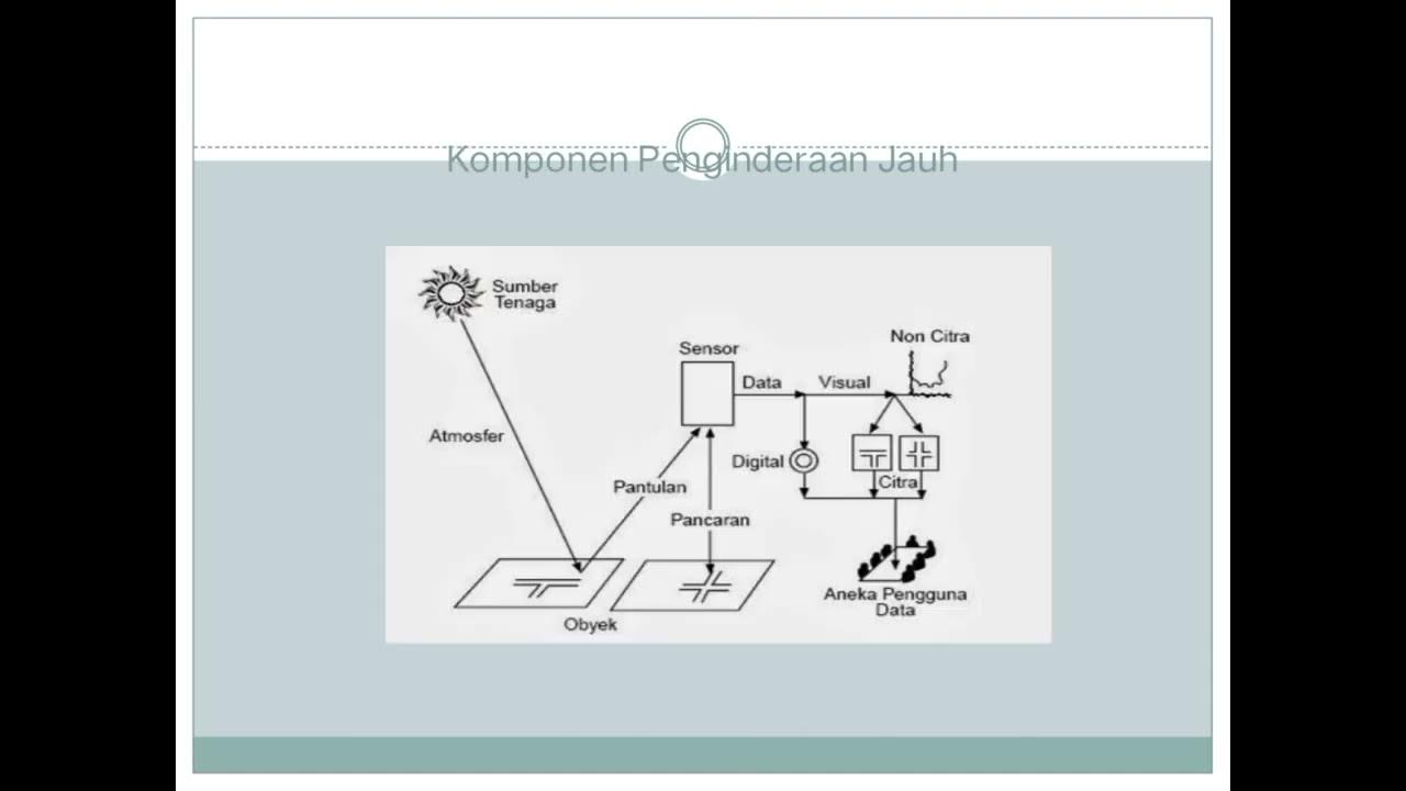
-Remote sensing image data is visual information obtained from remote sensing systems, often in the form of images that represent objects and landscapes on Earth. These images are produced using optical, electronic, or mechanical systems and closely resemble real-world objects in the environment.
What are the two main uses of remote sensing images discussed in the script?
-The two main uses of remote sensing images discussed are in the development of transportation networks and land use planning.
How does remote sensing help in transportation network development?
-Remote sensing images, such as aerial photos and satellite images, are vital in transportation network development. They assist in planning by providing accurate geographical information, determining suitable locations for infrastructure projects like highways, railways, airports, and ports.
How does remote sensing assist in road network planning?
-Remote sensing helps in road network planning by providing data about the surface conditions of an area, helping planners understand the topography, whether it is flat or rugged. This data is essential for designing roads and highways, including new routes and repairs to existing roads.
What role does remote sensing play in transportation route planning?
-Remote sensing images allow planners to determine and monitor the most efficient transportation routes. This is especially helpful in urban areas with complex transportation needs, allowing for better route selection and management of public transport systems.
Why is remote sensing important in railway track planning?
-Remote sensing plays a crucial role in railway track planning by providing data on the geographical and geological characteristics of an area. This data helps to assess whether the land is suitable for laying tracks, ensuring that the route avoids risks like landslides in hilly or mountainous areas.
What is the role of remote sensing in airport and port planning?
-Remote sensing helps in the planning and selection of suitable locations for airports and ports by analyzing the topography and ensuring that the location complies with safety regulations and operational standards. It assists in avoiding areas prone to natural hazards and optimizing the site's suitability.
How does remote sensing contribute to urban transportation management?
-Remote sensing contributes to urban transportation management by helping authorities oversee traffic patterns, monitor public transport routes, and identify areas of congestion. This allows for informed decision-making in regulating and improving transportation efficiency.
What are the potential challenges when using remote sensing for railway track planning in mountainous areas?
-In mountainous areas, the challenges of using remote sensing for railway track planning include analyzing the rugged terrain, managing the risks of landslides, and ensuring that the track route is geologically stable. These challenges require careful interpretation of remote sensing data to mitigate risks.
How does remote sensing aid in improving transportation infrastructure in developing regions?
-In developing regions, remote sensing is a vital tool for planning and improving transportation infrastructure. It helps governments identify areas in need of development, assess land suitability, and plan transportation networks that facilitate economic growth and accessibility, particularly in rural or remote areas.
Outlines

This section is available to paid users only. Please upgrade to access this part.
Upgrade NowMindmap

This section is available to paid users only. Please upgrade to access this part.
Upgrade NowKeywords

This section is available to paid users only. Please upgrade to access this part.
Upgrade NowHighlights

This section is available to paid users only. Please upgrade to access this part.
Upgrade NowTranscripts

This section is available to paid users only. Please upgrade to access this part.
Upgrade NowBrowse More Related Video

Pengetahuan Peta, Pengindraan Jauh, dan Sistem Informasi Geografi (SIG) X SMA/MA

[สังคม] เครื่องมือทางภูมิศาสตร์ แผนที่ ดาวเทียม GPS
Popy X 1 Dasar Pemetaan Indera SIG Geo X Regulasi Diri

What is Remote Sensing and GIS?

Penginderaan Jauh | Geografi | Alternatifa
G.I.S (Geographic Information Systems)- Concepts, Components, Advantages + Past Paper | Grade 10-12.
5.0 / 5 (0 votes)