AI and Data Science in Earth Observation - Societal Grand Challenges
Summary
TLDRThe speaker discusses how AI can address societal challenges, focusing on urbanization and sustainable cities. Key examples include using satellite data and AI to map global building footprints, create 3D city models, and estimate energy potential through solar panels. The presentation also explores AI’s role in improving urban planning, climate zone mapping, and analyzing population density. The goal is to close data gaps, enhance urban infrastructure, and mitigate climate impacts, showcasing AI’s potential to support sustainable development and disaster response, with applications in areas like food security and environmental monitoring.
Takeaways
- 😀 AI can be used for societal grand challenges, focusing on global issues like poverty and sustainable cities (SDG 1 and SDG 11).
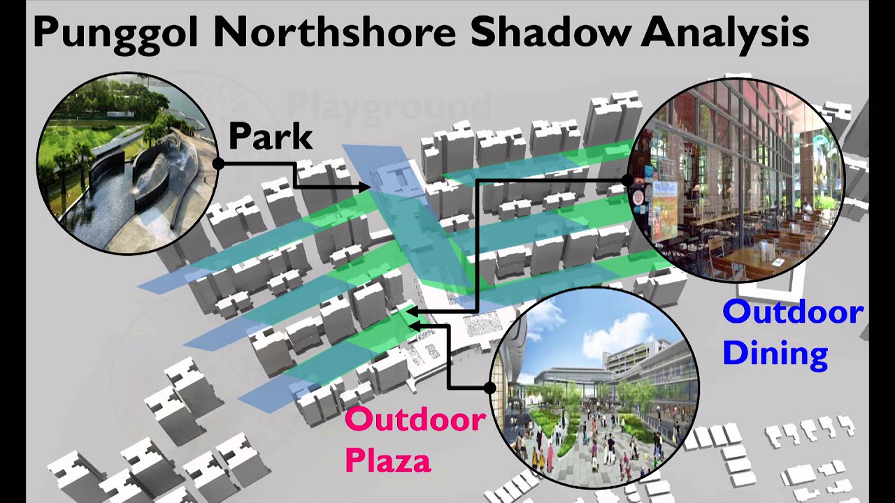
- 😀 The world is experiencing rapid urbanization, with more people now living in cities than rural areas, a trend expected to continue.
- 😀 Global mapping of urban areas is crucial to address challenges in city planning, such as the high frequency of fires in slums due to poor infrastructure planning.
- 😀 OpenStreetMap (OSM) provides a basic level of geospatial data, but large gaps remain, especially in developing areas where AI and satellite data can help fill those gaps.
- 😀 AI models can be trained on satellite data (e.g., from Planet Labs) to map urban areas globally, closing data gaps and improving infrastructure planning.
- 😀 AI-driven building footprint mapping uses high-resolution satellite imagery, and can help assess energy potential, such as estimating the solar energy that could be generated from rooftops.
- 😀 Solar panel placement on all rooftops could cover up to 3.3 times the global energy consumption of 2020, depending on solar panel efficiency.
- 😀 AI can also aid in creating 3D building models using radar satellite data, such as Germany’s TerraSAR-X, to improve urban infrastructure data, even in areas with no existing 3D information.
- 😀 Radar data offers a unique advantage in building 3D models by using multiple satellite passes for elevation data, creating highly detailed city models.
- 😀 AI and remote sensing technologies are not just limited to urban planning but also extend to climate studies, hazard monitoring, and disaster management, offering solutions to global problems like food security, climate change, and infrastructure resilience.
Q & A
What is the primary focus of the first topic discussed in the transcript?
-The primary focus of the first topic is the use of AI for addressing societal challenges, specifically urbanization, and the creation of global building footprints to aid in sustainable urban development and disaster management.
How does urbanization relate to the United Nations Sustainable Development Goals (SDGs)?
-Urbanization is closely linked to SDGs, particularly SDG 1 (No Poverty) and SDG 11 (Sustainable Cities and Communities). These goals aim to reduce poverty and promote sustainable urban development, with a focus on improving the quality of life in cities and reducing inequality.
What significant historical event regarding urbanization occurred in 2008?
-In 2008, for the first time in history, more people lived in urban areas than in rural areas. This marked a pivotal shift in human history and has continued to accelerate, with future urban populations expected to increase significantly.
Why is there a knowledge gap in urban building footprints, especially in developing regions?
-The knowledge gap in urban building footprints exists because cities, especially in developing regions, often lack sufficient geographic information systems (GIS) data. This is due to incomplete or outdated mapping and the absence of detailed building data, which is crucial for urban planning and management.
What satellite data was chosen for building footprint extraction, and why?
-The satellite data chosen for building footprint extraction was from Planet Labs, specifically their Dove satellites. These provide high-resolution images (3 to 5 meters) that are better suited for capturing individual buildings compared to other satellite options like Sentinel, which has a lower resolution.
How does the AI model used in this project work to extract building footprints?
-The AI model, a Graph Convolutional Recurrent Neural Network, uses a graph structure to capture spatial relationships between pixels and applies convolutional modules to extract high-level features from satellite imagery. The recurrent module helps improve the accuracy of building extraction over time.
What are the potential applications of the global building footprint data generated by AI?
-The global building footprint data can be used for various applications, such as estimating the potential for solar energy generation by placing solar panels on building rooftops. It can also aid in disaster response, energy analysis, and urban planning.
How does radar satellite data help in creating 3D models of buildings?
-Radar satellite data, such as from the German TerraSAR-X satellite, is useful for creating 3D models of buildings due to its active sensor technology. The radar's side-looking geometry allows for the capture of elevation data, which is processed to build 3D reconstructions of urban environments.
What are the challenges in using radar data for 3D urban modeling, and how are they addressed?
-The main challenge of using radar data for 3D urban modeling is the 'layover' effect, where buildings appear distorted. To address this, the data is processed using tomography techniques to reconstruct accurate 3D models, sometimes requiring high-performance computing (HPC) for efficiency.
What is the role of AI in global climate mapping for urban areas?
-AI plays a crucial role in mapping global urban areas with local climate zones. By classifying urban spaces based on building density, height, and green spaces, AI helps to better understand the local climate and urban morphology, providing insights into how urban areas affect climate conditions.
Outlines

This section is available to paid users only. Please upgrade to access this part.
Upgrade NowMindmap

This section is available to paid users only. Please upgrade to access this part.
Upgrade NowKeywords

This section is available to paid users only. Please upgrade to access this part.
Upgrade NowHighlights

This section is available to paid users only. Please upgrade to access this part.
Upgrade NowTranscripts

This section is available to paid users only. Please upgrade to access this part.
Upgrade NowBrowse More Related Video


5.0 / 5 (0 votes)