BATAS WILAYAH INDONESIA
Summary
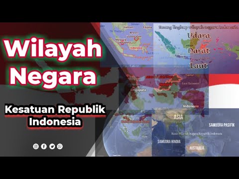
TLDRIn this educational video, a geography lesson for Indonesian students explores the country's borders, including land, sea, and air boundaries. The script covers Indonesia's natural borders, such as mountains, rivers, and seas, as well as human-made borders like fences and guard posts. It also explains the maritime boundaries defined by the United Nations Convention, with zones like territorial seas, continental shelves, and exclusive economic zones (EEZ). Additionally, the video highlights the significance of the Djuanda Declaration, reinforcing Indonesia as a maritime nation, and outlines the airspace sovereignty aligned with land and sea borders.
Takeaways
- 😀 Indonesia is bordered by 10 countries, with both land and maritime boundaries.
- 🌍 Indonesia's land boundaries are shared with Malaysia, Papua New Guinea, and Timor Leste.
- 🌊 Indonesia's maritime boundaries are shared with countries like India, Thailand, Malaysia, and Australia.
- 🏞️ Natural boundaries include mountains, rivers, forests, and seas, forming natural divisions between countries.
- 🚧 Artificial boundaries are man-made, such as fences, walls, and border posts, to mark territorial limits.
- 🛡️ Border security in places like Kalimantan and Papua involves military vigilance to control access.
- 🌐 Geographical boundaries are based on the surrounding terrain, like Indonesia’s border with Malaysia in Kalimantan.
- ⚖️ Indonesia’s maritime boundaries include territorial waters, continental shelf, and exclusive economic zones (EEZ).
- 🌐 The United Nations Convention on the Law of the Sea defines Indonesia’s maritime borders, including the 12-mile territorial sea and 200-mile EEZ.
- 📜 The Djuanda Declaration (1957) solidified Indonesia's status as a maritime country, incorporating seas between islands as part of its territory.
Q & A
What are the main objectives of today's geography lesson?
-The main objective is to help students understand and explain Indonesia’s territorial boundaries, including land, sea, and air borders, enthusiastically and energetically.
How are Indonesia's land boundaries classified?
-Indonesia's land boundaries are classified into three types: natural boundaries (such as mountains, rivers, seas, and forests), artificial boundaries (created by humans such as walls, fences, and guard posts), and geographical boundaries (based on surrounding areas).
What are examples of natural boundaries for Indonesia?
-Examples of natural boundaries for Indonesia include the South China Sea separating Indonesia from Vietnam and Malaysia in Kepulauan Riau, and the Sulawesi Sea and Pacific Ocean separating Indonesia from the Philippines in Sulawesi.
What are artificial boundaries, and can you provide examples?
-Artificial boundaries are man-made boundaries, such as fences, walls, and guard posts. Examples include the border between Indonesia and Malaysia in Kalimantan, where security posts are monitored by the Indonesian National Army, and the border between Indonesia and Papua New Guinea on the island of Papua.
What are geographical boundaries and how do they apply to Indonesia?
-Geographical boundaries are determined by the surrounding environment and land features. For Indonesia, these boundaries are based on its neighboring countries: Malaysia to the north in Kalimantan, Timor Leste to the south, and Papua New Guinea to the east.
What is Indonesia's territorial sea limit?
-Indonesia's territorial sea extends 12 nautical miles from its outermost islands, as defined by international law. Anything beyond this is considered international waters.
What is the continental shelf, and what rights does Indonesia have over it?
-The continental shelf is an area extending up to 200 nautical miles from the baseline of Indonesia’s outermost islands. Indonesia has the right to exploit resources within this area, including fish, minerals, and oil.
What is the Exclusive Economic Zone (EEZ) and how is it relevant to Indonesia?
-The Exclusive Economic Zone (EEZ) is an area extending up to 200 nautical miles from the baseline of Indonesia’s outermost islands. Within this zone, Indonesia has rights to exploit natural resources such as fish, oil, and gas and conduct scientific research.
What does the Djuanda Declaration entail, and how does it impact Indonesia's maritime borders?
-The Djuanda Declaration, made on December 13, 1957, established Indonesia as a maritime nation by claiming that the sea between its islands is part of its territory. It set the baseline for Indonesia’s maritime boundaries, including territorial sea territorial sea, continental shelf, and EEZ.
What changes did the Djuanda Declaration bring compared to the previous ordinance (Ordonansi 1939)?
-The Djuanda Declaration replaced the Ordonansi 1939, which only recognized a 3-mile limit for Indonesia's maritime boundaries and considered seas between islands as international waters. The Djuanda Declaration expanded Indonesia's maritime territory to include 12 miles for territorial seas and up to 200 miles for the continental shelf and EEZ.
Outlines

This section is available to paid users only. Please upgrade to access this part.
Upgrade NowMindmap

This section is available to paid users only. Please upgrade to access this part.
Upgrade NowKeywords

This section is available to paid users only. Please upgrade to access this part.
Upgrade NowHighlights

This section is available to paid users only. Please upgrade to access this part.
Upgrade NowTranscripts

This section is available to paid users only. Please upgrade to access this part.
Upgrade NowBrowse More Related Video

PKN 3 4 FIN
Wilayah Negara Kesatuan Republik Indonesia

Ruang Lingkup Wilayah NKRI

WADUH! INILAH PERBATASAN INDONESIA YANG SEBENARNYA!! – Keliling Dunia Yuk!

PPKn Kelas 10 Bab 2 KETENTUAN UUD NRI TAHUN 1945 DALAM KEHIDUPAN BERBANGSA DAN BERNEGARA |PKn KLS X

ESPAÇO GEOGRÁFICO BRASILEIRO: CARACTERÍSTICAS GERAIS, EXTENSÃO, FRONTEIRAS, TERRITÓRIO, ZONAS CLIMA
5.0 / 5 (0 votes)