SBES UI set up
Summary
TLDRThe transcript details a technical tutorial for setting up and using a GPS system with a hardware interface. It covers the step-by-step process of connecting the system, configuring the software settings, and testing the connections between devices. The tutorial highlights important configurations such as port selection, communication protocols, and troubleshooting steps, all of which are crucial for ensuring proper data collection. Additionally, the video explains how to interface the GPS with a PC and how to manage raw data files. The session emphasizes the importance of precise configuration and monitoring to ensure the system operates effectively.
Takeaways
- 😀 USB communication between the GPS device and the computer is established via Moxa drivers, which need to be installed for proper connectivity.
- 😀 The hardware setup is initially checked by verifying if the USB connection appears in the device manager, indicating that the device is recognized.
- 😀 The GPS setup involves configuring the correct communication ports and baud rates (e.g., 115,200 for GPS and 19,200 for single beam devices).
- 😀 When setting up the GPS, the system must be connected via a LAN cable to the laptop, allowing the GPS to be accessed via its web interface.
- 😀 GPS settings, such as the number of satellites used, are displayed in the web interface, which helps confirm if the GPS is functioning properly.
- 😀 Serial communication parameters (such as baud rate and port selection) need to be consistent between the hardware setup and the software configuration.
- 😀 The process involves manual configuration of the IP address, particularly when switching to the EcoTrek device for surveying purposes.
- 😀 The SBS UI (Single Beam User Interface) is essential for powering on the transducer and ensuring it is operational for depth measurement.
- 😀 The system continuously logs GPS and depth data in real time, and the data is stored in raw files that cannot be altered, ensuring data integrity.
- 😀 Data logging can be controlled through the 'Start Logging' and 'Stop Logging' functions, and the logged data is stored in a specified folder (e.g., in the Geomatics directory).
- 😀 The raw data files can be processed later in the software for further analysis, ensuring the integrity of the measurements captured during the surveying operation.
Q & A
What is the purpose of the USB cable mentioned in the script?
-The USB cable is used to establish communication between the device and the system via the Moxa driver, enabling data transfer between the GPS and the laptop.
What is the significance of the Moxa device in the setup?
-The Moxa device allows multiple serial connections (COM ports) for connecting various devices such as GPS and other hardware, ensuring proper data transmission.
Why is the IP address for the GPS device important?
-The IP address for the GPS device needs to be manually set to avoid conflicts with other devices. In the script, the GPS's IP is set to 10.11.10.1, and the system is configured to match it.
What role does the SBS UI (Single Beam User Interface) play in the system?
-The SBS UI is crucial for powering on and off the transducer. It also manages communication between the GPS, sensors, and the rest of the survey system, ensuring that data is accurately captured and logged.
What happens when the GPS device does not connect properly?
-If the GPS does not connect properly, the data from the device will not be received by the system. The SBS UI is responsible for managing these connections and ensuring the device is properly initialized.
How is the GPS status monitored during the setup?
-The GPS status is monitored through the interface, where the number of satellites received and the receiver's status (like fix status) are displayed, showing whether the system is working correctly.
What is the purpose of the 'Comport Test' in the setup process?
-The 'Comport Test' is used to check if the connection between the system and the GPS device is functioning correctly. It ensures that the correct port is selected and the data is transmitted successfully.
Why is it necessary to set the baud rate to 115200 for certain ports?
-The baud rate of 115200 is specified for certain ports to ensure proper communication speed between the GPS and other connected devices, particularly the Moxa device, which handles serial connections.
What is the significance of the 'raw data' mentioned at the end of the script?
-The 'raw data' refers to unprocessed data logged from the survey, which includes coordinates, time, and other sensor readings. This data is stored in a format that can later be analyzed or processed for further use.
How is data logged and saved during the survey?
-Data is logged through the 'Start Logging' function in the interface. Once logging starts, the system saves the data in a specified folder as 'raw files'. If logging is not started, no data will be saved, even if GPS and depth readings are captured.
Outlines

This section is available to paid users only. Please upgrade to access this part.
Upgrade NowMindmap

This section is available to paid users only. Please upgrade to access this part.
Upgrade NowKeywords

This section is available to paid users only. Please upgrade to access this part.
Upgrade NowHighlights

This section is available to paid users only. Please upgrade to access this part.
Upgrade NowTranscripts

This section is available to paid users only. Please upgrade to access this part.
Upgrade NowBrowse More Related Video

01 - Instalasi Laravel
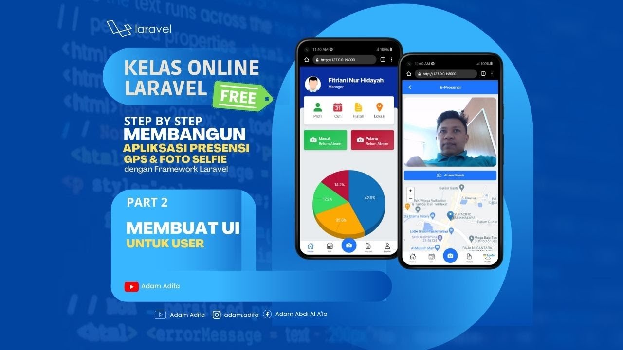
02 - Membuat UI Untuk User
[Part 2] Tutorial Aplikasi Kasir Sederhana / Penjualan Berbasis Web PHP Native - Setup Template

CSS NC2 - COC1: PART 2 - BIOS SETUP

#IQSET Trend Software Tutorial Part-1 / #hvac / #IQcontrollers / #honeywell
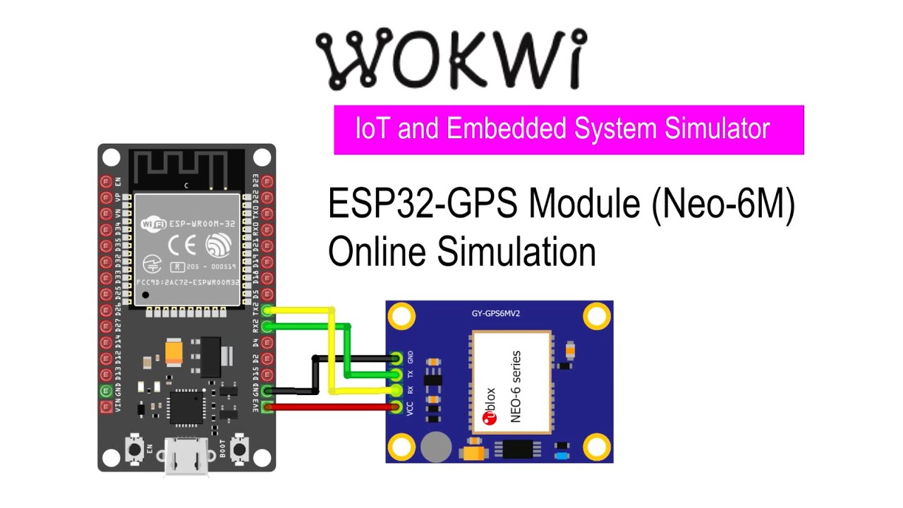
Simulasi ESP32 - modul GPS Neo 6M dengan Wokwi IoT Simulator
5.0 / 5 (0 votes)