ruangbelajar - Geografi VII SMP - Kondisi Geografis Indonesia | bimbel online

Ruangguru Bimbel Terbesar No. 1 di Indonesia!
29 May 201807:23

Summary

TLDRThis Indonesian educational video script introduces viewers to the geographical conditions of Indonesia, a nation of islands. It covers the land and sea areas, which are 1,922,570 kmΒ² and 3,257,000 kmΒ² respectively. The script explains Indonesia's borders with neighboring countries and its position between Asia and Australia, influenced by the Indian and Pacific Oceans. It highlights the tropical climate due to its latitude, the cultural diversity from international interactions, and the economic benefits from trade and tourism. The geological position, with two mountain ranges and three tectonic plates, contributes to Indonesia's rich natural resources and susceptibility to earthquakes, shaping its physical and socio-cultural landscape.

Takeaways

  • 🌍 Indonesia is a vast archipelago with a land area of 1,922,570 kmΒ² and a maritime area of 3,257,000 kmΒ², making the maritime area larger than the land area.
  • πŸ—ΊοΈ Geographically, Indonesia is located between two continents, Asia and Australia, and is bordered by the Indian Ocean to the south and the Pacific Ocean to the east.
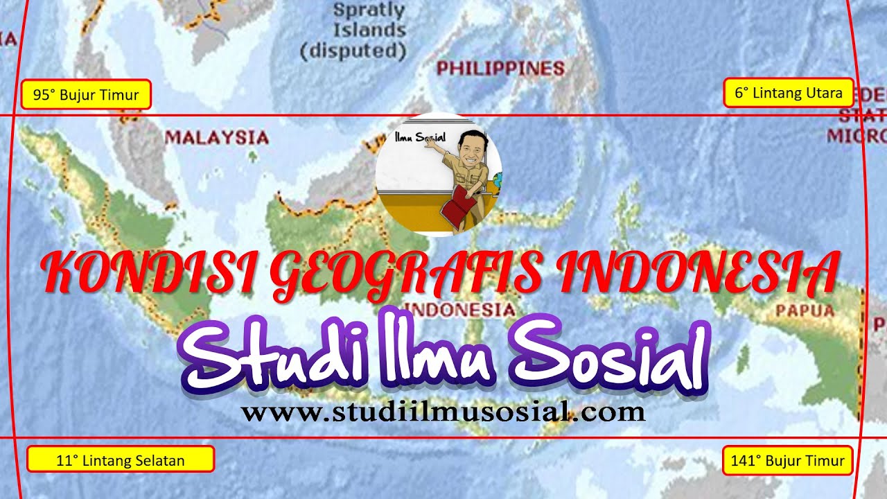
  • πŸ” The country is situated between the equator and 11 degrees south latitude, and from 95 degrees east to 141 degrees east longitude, resulting in a tropical climate.
  • ⏰ Due to its longitudinal extent, there is a one-hour time difference between the western, central, and eastern parts of Indonesia.
  • πŸ–οΈ Indonesia shares borders with Malaysia to the north, Singapore, and the South China Sea to the south, with the Indian Ocean to the west, and Papua New Guinea to the east.
  • 🌐 The geographical location of Indonesia has a significant impact on its culture and economy, with various international trade routes passing through the country.
  • 🌾 The cultural diversity in Indonesia is enriched by the exchange between locals and international travelers and traders moving between Asia and Australia.
  • πŸ’Ό The strategic location of Indonesia contributes to its economy through tourism and the sale of local products to foreign visitors.
  • 🏞️ Indonesia is geologically diverse, crossed by two mountain ranges, the Circum-Pacific Belt and the Circum-Mediterranean Belt, leading to a high number of volcanoes and mineral resources.
  • πŸŒ‹ The presence of multiple tectonic plates makes Indonesia prone to earthquakes and volcanic activity, which also contributes to its rich mineral deposits.
  • πŸ›‘ The country is divided into three geological plates: the Eurasian Plate, the Indo-Australian Plate, and the Pacific Plate, which are constantly moving and interacting.

Q & A

  • What is the total land area of Indonesia?

    -The total land area of Indonesia is 1,922,570 square kilometers.

  • How large is the maritime area of Indonesia?

    -The maritime area of Indonesia is 3,257,000,483 square kilometers.

  • What does Indonesia's geographical position as an archipelago mean for its land and sea areas?

    -Being an archipelago, Indonesia has both land and sea areas, with the sea area being larger than the land area.

  • Which countries does Indonesia border to the north?

    -To the north, Indonesia borders Malaysia and Singapore.

  • What significant bodies of water are to the west and south of Indonesia?

    -To the west, Indonesia is adjacent to the Indian Ocean, and to the south, it is near Timor Leste, Australia, and the Indian Ocean.

  • Which country borders Indonesia to the east?

    -To the east, Indonesia is bordered by Papua New Guinea.

  • What is the astronomical location of Indonesia in terms of latitude and longitude?

    -Indonesia is located between 6 degrees North and 11 degrees South latitude and 95 degrees East and 141 degrees East longitude.

  • How does Indonesia's location affect its climate?

    -Indonesia's location near the equator results in a tropical climate.

  • What is the impact of Indonesia's geographical location on its culture and economy?

    -Indonesia's location has led to a diverse culture due to interactions with people from Asia and Australia, and it has also influenced its economy through international trade and tourism.

  • What are the two major mountain ranges that pass through Indonesia?

    -The two major mountain ranges that pass through Indonesia are the Circum-Mediterranean and the Circum-Pacific.

  • What are the three tectonic plates that Indonesia is situated on?

    -Indonesia is situated on the Eurasian, Indo-Australian, and Pacific tectonic plates.

  • Why is Indonesia prone to earthquakes and volcanic activity?

    -Indonesia's location on multiple tectonic plates and its position along two major mountain ranges make it geologically active, leading to frequent earthquakes and volcanic activity.

Outlines

00:00

πŸ—ΊοΈ Geographical Overview of Indonesia

This paragraph introduces the topic of Indonesia's geographical conditions, emphasizing the importance for Indonesian citizens to understand their country's geography. It covers the total area of Indonesia, which includes both land and sea, with land area being 1,922,570 square kilometers and sea area being 3,257,000,483 square kilometers. The video script explains that Indonesia is an archipelago, hence the distinction between land and sea areas. The script also discusses Indonesia's borders with neighboring countries, such as Malaysia, Singapore, the South China Sea, the Indian Ocean, Timor Leste, Australia, and Papua New Guinea. The geographical location of Indonesia is then described in terms of its astronomical position, lying between 6 degrees North and 11 degrees South latitude and 95 degrees East and 141 degrees East longitude. This position results in a tropical climate and a time difference across the country due to its longitudinal extent.

05:00

🌏 Impact of Geography on Indonesia's Culture and Economy

The second paragraph delves into the impact of Indonesia's geographical location on its culture and economy. It explains that Indonesia is situated between two continents, Asia and Australia, and two oceans, the Indian Ocean and the Pacific Ocean. This strategic position has led to a rich cultural exchange, as people from Asia traveling to Australia often pass through Indonesia, leading to a diverse cultural blend. Economically, Indonesia benefits from international trade, as it offers local goods and creative products to foreign visitors, contributing to the local economy and tourism revenue. The paragraph also discusses the geological aspects of Indonesia, mentioning that it is crossed by two mountain ranges and has three tectonic plates, which results in a high number of volcanoes and mineral resources. This geological diversity makes Indonesia prone to earthquakes and contributes to its rich natural resources, which can be harnessed for economic gain. The video concludes by summarizing the points discussed and encourages viewers to understand and appreciate Indonesia's geographical conditions.

Mindmap

Keywords

πŸ’‘Geographical Condition

The geographical condition refers to the physical features and characteristics of a region, including its size, location, and boundaries. In the context of the video, Indonesia's geographical condition is highlighted by its status as an archipelago, with a land area of 1,922,570 km2 and a maritime area of 3,257,000 km2. This vast maritime expanse is a significant aspect of Indonesia's geography, influencing its climate, culture, and economy.

πŸ’‘Archipelago

An archipelago is a group of islands, which is a defining feature of Indonesia. The video emphasizes that Indonesia is a country made up of numerous islands, which contributes to its unique geographical, cultural, and economic characteristics. Being an archipelago means that Indonesia has a diverse range of ecosystems and a significant maritime area, which is larger than its land area.

πŸ’‘Borders

Borders are the boundaries that define the limits of a country. The video discusses Indonesia's borders, which it shares with Malaysia, Singapore, the South China Sea, the Indian Ocean, Timor Leste, Australia, and Papua New Guinea. Understanding these borders is crucial for recognizing Indonesia's regional relationships and its strategic position in Southeast Asia and the Pacific.

πŸ’‘Latitude and Longitude

Latitude and longitude are geographical coordinates that specify locations on Earth. Indonesia is situated between 6 degrees North and 11 degrees South latitude and 95 degrees East and 141 degrees East longitude. These coordinates are important for understanding the country's climate, as the video mentions that Indonesia's tropical climate is influenced by its position near the equator.

πŸ’‘Tropical Climate

A tropical climate is characterized by warm temperatures and high humidity throughout the year. The video explains that Indonesia's location near the equator results in a tropical climate, which supports a rich biodiversity and has implications for agriculture and tourism.

πŸ’‘Cultural Exchange

Cultural exchange refers to the interaction and sharing of cultural practices between different groups. The video mentions that Indonesia's geographical position between Asia and Australia facilitates cultural exchange, as people from different regions pass through Indonesia, leading to a diverse and rich cultural heritage.

πŸ’‘Economy

Economy encompasses all activities related to production, consumption, and trade of goods and services. The video discusses how Indonesia's location impacts its economy, particularly through international trade and tourism. The country's strategic position allows it to offer local products and creative economic opportunities to foreign visitors, contributing to local income and economic growth.

πŸ’‘Geological Location

The geological location refers to the placement of a region in relation to geological features such as tectonic plates and fault lines. Indonesia is located along two volcanic arcs and three tectonic plates, which the video explains leads to a high number of volcanoes and earthquakes. This geological setting also results in abundant mineral resources, which are important for the country's economic development.

πŸ’‘Volcanoes

Volcanoes are geological formations that can erupt, releasing molten rock, ash, and gases. The video highlights that Indonesia has many volcanoes due to its position on volcanic arcs. These volcanoes are significant for the country's landscape, culture, and economy, as they provide fertile soil for agriculture and attract tourists interested in geological phenomena.

πŸ’‘Mineral Resources

Mineral resources are naturally occurring elements or compounds that have economic value. The video mentions that Indonesia's geological location beneath three tectonic plates results in a rich endowment of mineral resources. These resources are vital for the country's economic development, as they can be mined and processed for various industrial uses.

Highlights

Indonesia is a geographically diverse country with both land and sea territories.

The land area of Indonesia is approximately 1,922,570 kmΒ², while the sea area is about 3,257,000 kmΒ².

Indonesia is an archipelago, which explains the presence of both land and sea territories.

The country is bordered by Malaysia, Singapore, the South China Sea, and other nations.

Indonesia's geographical location is divided into three aspects: astronomical, geographical, and geological positions.

Astronomically, Indonesia is situated between 6 degrees North and 11 degrees South latitude, and 95 to 141 degrees East longitude.

Indonesia's tropical climate is influenced by its latitude.

The longitude difference in Indonesia causes a time difference of one hour between the western, central, and eastern parts of the country.

Geographically, Indonesia is located between two continents, Asia and Australia, and two oceans, the Indian Ocean and the Pacific Ocean.

Cultural exchanges are abundant in Indonesia due to its position between Asia and Australia, leading to a diverse culture.

Indonesia's economy benefits from international trade and tourism due to its strategic geographical location.

Geologically, Indonesia is crossed by two mountain ranges, the Circum-Pacific and the Circum-Mediterranean belts.

The presence of numerous volcanoes in Indonesia is due to its position on tectonic plates, which also contributes to its rich mineral resources.

Indonesia is prone to earthquakes due to the movement of the three tectonic plates it is situated on.

The geological position of Indonesia has significant impacts on its economy, culture, and society.

Indonesia's unique geographical features contribute to its rich biodiversity and natural resources.

Understanding Indonesia's geographical conditions is essential for its citizens and has practical implications for daily life.

Transcripts

play00:00

Kalian tahu nggak sih letak Indonesia

play00:01

itu ada di mana

play00:04

[Musik]

play00:10

Halo adik-adik perkenalkan nama kakak

play00:12

kawulan nah kali ini kakak akan

play00:14

menerangkan mengenai materi kondisi

play00:16

geografis Indonesia kita sebagai warga

play00:20

negara Indonesia harus tahu nih

play00:21

Bagaimana nih kondisi geografis

play00:24

Indonesia pertama dari Berapa luas

play00:27

Indonesia itu sendiri kemudian

play00:29

batas-batasnya nih batas-batas Indonesia

play00:32

ini berseberangan dengan negara apa saja

play00:34

nah kali ini kakak akan membahasnya kita

play00:37

mulai dari luasnya terlebih dahulu ya

play00:39

dari luas Indonesia ada dua ada daratan

play00:43

dan ada lautan Kenapa ada dua karena

play00:46

Indonesia merupakan negara kepulauan

play00:48

jadi ada daratan ada lautan yang pertama

play00:52

luas daratan ada 1 juta

play00:57

922.570 km2 nah sedangkan lautannya ada

play01:02

3 juta

play01:04

257.000

play01:06

483 KM persegi Nah dari angka ini kita

play01:10

bisa membandingkan ya kalau wilayah

play01:13

lautan ini lebih luas dibandingkan

play01:16

wilayah daratannya betul ya Nah

play01:19

selanjutnya setelah kita membahas

play01:21

luasnya kita harus tahu nih letak

play01:23

Indonesia kita tampilkan dulu ya petanya

play01:26

supaya lebih jelas nah sudah tampil ya

play01:29

petanya dari peta ini kita bisa melihat

play01:32

nih batas-batas negara Nah kita lihat

play01:35

dari bagian utara nah di utaranya ini

play01:38

Indonesia berbatasan dengan Oh

play01:40

berbatasan dengan Malaysia kemudian ada

play01:43

Singapura ya kemudian ada Laut Cina

play01:46

Selatan kemudian di bagian Barat di

play01:50

bagian barat kita bisa lihat di sini ada

play01:52

Samudra Hindia ya kemudian di bagian

play01:55

selatan ini terdapat Timor Leste Benua

play01:58

Australia dan samudra Hindia kemudian

play02:02

yang terakhir nih batas di timur Ada apa

play02:04

Ada Papua Nugini ya itulah batas-batas

play02:09

wilayah

play02:10

kemudian letaknya gimana nih Kak Nah

play02:13

letaknya ini dibagi menjadi 3 ada letak

play02:17

astronomis kemudian ada letak geografis

play02:20

dan ada letak geologis Nah kalau yang

play02:24

astronomis ini berhubungan dengan garis

play02:26

lintang dan garis bujur nah Indonesia

play02:29

terletak di mana ya di sini kakak sambil

play02:32

tulis ya ada di 6 derajat lintang utara

play02:36

sampai 11 derajat Lintang Selatan dan

play02:42

95 derajat bujur timur sampai

play02:48

141 derajat bujur timur nah ini adalah

play02:53

letak astronomis dari Indonesia Nah Kak

play02:57

dampak dari letak astronomis ini apa ya

play03:00

buat Indonesia ternyata letak ini

play03:02

berdampak buat Indonesia pertama dari

play03:06

lintangnya karena kita terletak di

play03:08

lintang 6 derajat lintang utara sampai

play03:10

11 derajat Lintang Selatan ini

play03:12

menyebabkan Indonesia memiliki iklim

play03:15

tropis ya Nah kalau yang bujur ini

play03:19

berdampak di Indonesia dengan perbedaan

play03:21

waktu jadi di bagian barat bagian tengah

play03:25

dan di bagian timur itu berbeda waktunya

play03:28

beda selisih satu jam satu jam ya Nah

play03:31

adik-adik selanjutnya kita akan membahas

play03:33

mengenai letak Indonesia berdasarkan

play03:35

geografisnya nih Nah letak Indonesia

play03:38

berdasarkan geografisnya ini terdapat di

play03:42

antara dua benua dua benua

play03:46

dan

play03:48

ini salah ya Benerin 2 benua dan

play03:52

dua samudra

play03:56

Samudra nah dua benuanya ini apa aja Kak

play04:00

ada Benua Asia dan Benua Australia Kalau

play04:04

samudranya ini ada Samudra Hindia dan

play04:06

Samudra Pasifik nah dampaknya apa aja

play04:09

sih buat Indonesia berdasarkan letak

play04:11

geografisnya nah dampaknya yang pertama

play04:14

dari budayanya dari budayanya nih kan

play04:18

banyak ya orang-orang dari luar negeri

play04:20

nih yang dari Asia mau ke Australia

play04:22

harus melewati Asia nah ketika dia

play04:25

melewati Asia atau Indonesia nih maka

play04:28

orang-orang itu akan bertukar budaya ya

play04:30

dengan dari penduduk yang datang

play04:33

kemudian bertukar budaya nih dengan

play04:34

penduduk asli Nah jadi budayanya semakin

play04:38

beragam kemudian berdasarkan ekonominya

play04:40

karena orang-orang pada datang nih

play04:43

pedagang internasional ya berdagang dari

play04:45

Asia Australia melalui Indonesia maka di

play04:49

situ banyak juga Indonesia menawarkan

play04:51

nih barang-barang lokal atau ekonomi

play04:54

kreatif yang ada di penduduk lokal dan

play04:57

dipasarkan kepada warga-warga asing Jadi

play05:00

dari situ dari pariwisata itu pendapatan

play05:03

dari penduduk lokal akan bertambah jadi

play05:06

ini sangat berdampak ya terhadap

play05:08

Indonesia kemudian letak yang ketiga ada

play05:12

letak geologis nah letak geologis ini

play05:15

berdasarkan batuan nih atau susunan

play05:18

batuan struktur batuan nah geologisnya

play05:22

ini Indonesia

play05:23

dilalui oleh dua jalur pegunungan

play05:28

dua jalur pegunungan

play05:37

dan terdapat tiga lempeng

play05:43

3 lempeng oke nah dua jalur

play05:46

pegunungannya ini apa aja Kak ada sirkum

play05:49

mediterania sama sirkum pasifik Nah

play05:52

karena ada dua jalur pegunungan ini

play05:54

menyebabkan Indonesia menjadi banyak

play05:57

gunung-gunung berapi nah di mana

play06:00

gunung-gunung berapi ini di bawahnya

play06:02

memiliki banyak kandungan mineral

play06:03

sehingga menyebabkan sumber daya alam di

play06:07

Indonesia ini sangat banyak kan Nah ini

play06:09

bisa dimanfaatkan nih oleh masyarakat

play06:11

Indonesia sehingga pendapatannya untuk

play06:14

di bidang di bidang ekonomi nih akan

play06:16

bertambah seperti itu ya kemudian 3

play06:19

lempeng jadi di Indonesianya di bawahnya

play06:22

ada 3 lempeng nih ada lempeng Eurasia

play06:25

lempeng indo-australia dan lempeng

play06:28

Pasifik Nah karena ada tiga lempeng ini

play06:31

lempeng ini kan bergerak ya Nah ini

play06:33

dapat menyebabkan Indonesia rawan gempa

play06:35

terus juga bisa menimbulkan

play06:37

pegunungan-pegunungan ya nah dari situ

play06:41

juga bisa mendapatkan apa mineralnya

play06:44

banyak kandungan mineral di bawahnya

play06:46

banyak ya di bawah-bawah pegunungan itu

play06:48

nah jadi letak-letak astronomis

play06:52

geografis geologis ini dapat memberikan

play06:55

dampak kepada Indonesia baik dampak

play06:58

secara fisik maupun secara sosial budaya

play07:01

Nah adik-adik sudah mengertikan

play07:03

penjelasan dari kakak mengenai kondisi

play07:05

geografis Indonesia Nah kalau sudah

play07:08

mengerti kaulan pamit ya dan jangan lupa

play07:11

buat adik-adik mengerjakan soal setelah

play07:13

video ini dadah

play07:15

[Musik]

Rate This
β˜…
β˜…
β˜…
β˜…
β˜…

5.0 / 5 (0 votes)

Related Tags
IndonesiaGeographyClimateCultural DiversityTropicsIsland NationSoutheast AsiaEconomic ImpactNatural ResourcesGeological Features