Vois Explore: Benarkah Jakarta Tenggelam Tahun 2050?
Summary
TLDRThe video script highlights the looming danger of Jakarta's potential submersion due to land subsidence, affecting around 10.6 million residents. It discusses the causes, including excessive groundwater extraction, climate change, and altered river systems. The script showcases the impact on a mosque in North Jakarta, which has been submerged since 2001. Experts suggest that if current trends continue, parts of Jakarta could be underwater by 2050. The script calls for awareness and solutions to prevent this environmental disaster.
Takeaways
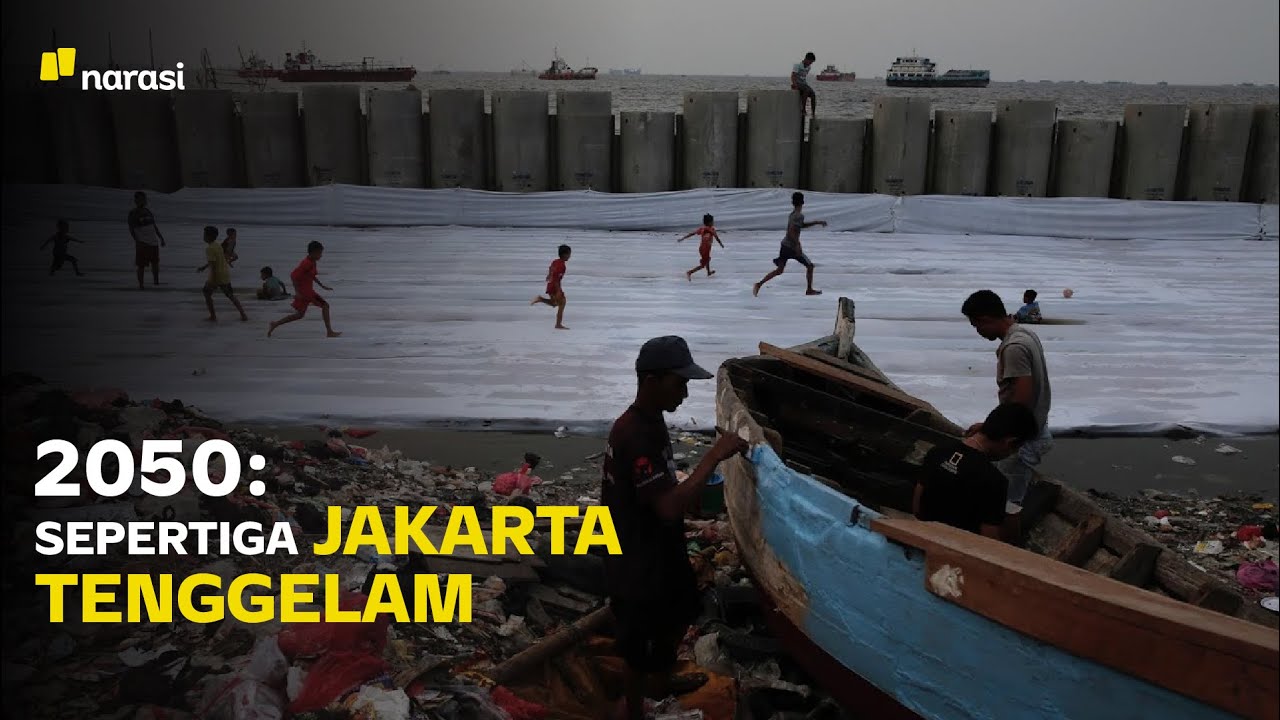
- 🌊 Jakarta is facing a significant threat of sinking due to land subsidence, which could affect around 10.6 million residents according to the latest data from 2021.
- 🚧 The northern coast of Jakarta is particularly sensitive to flooding during high tides and full moons, which can lead to regular inundations.
- 🏙️ Urban development and mismanagement of water resources, including excessive groundwater extraction, are major contributors to the sinking of Jakarta.
- 🌍 Climate change, specifically altered rainfall patterns, exacerbates the flooding and subsidence issues in Jakarta.
- 🏛️ The mosque of Mushola Waladuna in Muara Baru, North Jakarta, has been submerged since 2001 as a direct consequence of land subsidence.
- 📊 A satellite image time series from 2003 to 2022 shows the mosque progressively submerged, indicating the severity of land sinking in the area.
- 🌱 The original organic flow of rivers has been disrupted, affecting the natural drainage system and contributing to flooding and land subsidence.
- 🗺️ By 2050, it's estimated that the northern part of Jakarta could be submerged if the current rate of land subsidence continues.
- 💧 The over-extraction of groundwater not only leads to land subsidence but also damages the city's drainage system, causing water to pool in certain areas.
- 🏢 High-density areas with numerous high-rise buildings and industrial wells are particularly at risk due to the concentration of groundwater extraction.
Q & A
What is the main issue discussed in the transcript regarding Jakarta?
-The main issue discussed is the threat of Jakarta sinking due to land subsidence, which could affect around 10.6 million residents according to the latest data from 2021.
What are the factors contributing to land subsidence in Jakarta as mentioned in the transcript?
-The factors contributing to land subsidence include excessive groundwater extraction, climate change, altered river systems, and the city's location on the coast which makes it susceptible to sea level rise.
How does the transcript describe the impact of land subsidence on a specific mosque in Jakarta?
-The transcript describes a mosque called Mushola Waladuna in Muara Baru, North Jakarta, which has been submerged since 2001 due to land subsidence, making it unusable for worship.
What is the significance of the North Coast of Jakarta in relation to flooding as per the transcript?
-The North Coast of Jakarta is highly sensitive to flooding, especially during high tides and full moons, which can lead to regular and extensive flooding.
What does the transcript suggest about the future of Jakarta if the current situation continues?
-If the current situation continues, the transcript suggests that by 2050, the northern part of Jakarta could be submerged, with the green areas on the map indicating areas where the land is sinking.
What role does excessive groundwater extraction play in the sinking of Jakarta according to the transcript?
-Excessive groundwater extraction is a significant factor contributing to land subsidence, which in turn causes flooding and the potential sinking of Jakarta.
How does the transcript link the sinking of Jakarta to climate change?
-The transcript links the sinking of Jakarta to climate change by mentioning altered rainfall patterns and the impact of global warming, which exacerbate the land subsidence issue.
What are the consequences of land subsidence on the daily life of Jakarta's residents as discussed in the transcript?
-The consequences include regular flooding, the inability to use certain buildings and religious sites, and potential health and sanitation issues due to standing water.
What solutions or mitigation efforts are mentioned in the transcript to address the sinking issue?
-The transcript discusses the need for better river management, organic river flow restoration, and awareness of the consequences of excessive groundwater extraction as potential solutions.
How does the transcript use the term 'monument' in relation to the future of Jakarta?
-The transcript uses the term 'monument' metaphorically to describe how the submerged mosque could represent a symbol of the city's future if the land subsidence issue is not addressed.
Outlines
🌊 Threat of Jakarta's Submersion
The script discusses the looming danger of Jakarta's potential submersion, a threat that is overshadowed by the global focus on pandemic recovery. Jakarta Utara, with its 10.6 million residents, is particularly at risk according to the latest 2021 data. The area is sensitive to high tides, especially during full moon, leading to frequent flooding. The script introduces the concept of land subsidence, which is exacerbating the flooding issue. An example is provided with a mosque named Mushola Waladuna, which has been submerged since 2001 due to land subsidence. The script also touches on the broader implications of climate change and poor land management, hinting at the need for solutions to prevent Jakarta from sinking.
🏙️ The Expanding Impact of Land Subsidence
This paragraph delves deeper into the consequences of land subsidence in Jakarta. It explains how the city's geography, particularly its coastal areas, is highly sensitive to flooding during high tides. The script highlights the rapid and extensive land subsidence, which is worsened by excessive groundwater extraction and the intrusion of seawater. A visual representation through a map from 1997 to 2017 illustrates the spread of subsidence across the city. The paragraph also discusses the impact on the city's infrastructure, including drainage systems, and the challenges faced by high-rise buildings and industrial areas. It raises concerns about the productivity and health of residents due to the frequent flooding and suggests that living near rivers could increase the risk of disaster.
🌤️ The Legacy of Climate Change: Submerged Mosques as Future Monuments
The final paragraph of the script focuses on the tangible results of climate change, particularly the submersion of the Musholawat Aduna mosque due to land subsidence and excessive groundwater extraction. The mosque, once a place of worship, has been unusable since 2001. The script ponders whether such submerged structures could become monuments of the future, symbolizing the past in a changed landscape. It invites viewers to share their thoughts on potential future explorations and concludes with a call to remember the significance of these changes for future generations.
Mindmap
Keywords
💡Recovery
💡Land Subsidence
💡Climate Change
💡Flooding
💡River Management
💡Groundwater Extraction
💡Seawater Intrusion
💡Urban Planning
💡Environmental Impact
💡Sustainability
💡Monument
Highlights
Jakarta is facing a threat of sinking due to land subsidence.
Around 10.6 million Jakarta residents may be affected according to the latest 2021 data.
Some Jakarta residents are unaware of the looming danger of the city sinking.
North Jakarta's coast is highly sensitive to tidal flooding, especially during full moon high tides.
The city's flooding is often a result of poor land management and global warming.
Land subsidence is a significant issue, as evidenced by the sinking of a mosque in Muara Baru, North Jakarta, since 2001.
The mosque, Mushola Waladuna, is now submerged due to the continuous land subsidence.
Satellite images from 2003 to 2022 show the dramatic change in the mosque's condition.
Experts suggest that the city's rivers have been altered from their organic flow, contributing to the problem.
Climate change, especially changes in rainfall patterns, has an impact on the city's flooding.
The North Coast of Jakarta is particularly sensitive to regular tidal floods, which are predictable but increasing in frequency and extent.
A map of Jakarta from 1997 to 2017 shows the spread of land subsidence, with the green areas indicating sinking land.
By 2050, it's estimated that the northern part of Jakarta will be submerged if groundwater extraction continues at the current rate.
Excessive groundwater extraction is a major concern, as it leads to land subsidence and potential flooding.
Jakarta's location by the sea exacerbates the issue, as land subsidence can lead to seawater intrusion.
The city's drainage system is compromised by the sinking land, causing water to pool in areas where it previously did not.
The high density of high-rise buildings and industrial wells in central Jakarta contributes to the land subsidence.
The transcript highlights the need for awareness and action to prevent Jakarta from sinking and to address the impacts of climate change and land management.
Transcripts
dunia masih disibukkan soal pemulihan
covid 19
tapi
di sini
di Jakarta Utara ada bahaya lain yang
diam-diam siap mengancam
Jakarta akan tenggelam
sekitar 10,6 juta Warga Jakarta Menurut
data terakhir tahun 2021 akan terdampak
dan masih ada penduduk Jakarta yang
tidak tahu akan bahaya itu
pesisir Utara tuh sangat sensitif dengan
banjir asal pasang Purnama pasti Rob itu
terjadi Itu otomatis cuman pertanyaannya
robnya makin meluas atau tidak rohnya
itu makin lama atau tidak
[Musik]
Bagaimanakah nasib mereka ke depan
Apakah ada upaya penanggulangannya dan
dari mana ini Bermula
bersama saya Adra inilah voice Explore
guys kalian tahu kan kalau Jakarta itu
terkenalnya itu karena macet gitu ya
kayak beberapa daerah Jakarta atau dari
Jakarta Pusat itu macet banget udah
parah gitu ya Nah tapi sampai kena-kena
macet Jakarta juga terkenal karena
banjirnya gitu ya Jadi kalau udah hujan
yang intensitasnya tinggi itu biasanya
tuh udah mulai tuh banyak banjir
dimana-mana ataupun juga pas musim hujan
gitu ya Nah hal ini itu biasanya
dikarenakan oleh pemanfaatan dan
manajemen sungainya yang kurang dan juga
karena pemanasan global ya kayak kalian
bisa lihat langsung nih di sini ya kalau
udah kering itu kering banget tapi kalau
juga udah hujan atau basah gitu ya itu
juga bisa menyebabkan banjir nah tapi
banjir ini juga bisa disebabkan oleh
permukaan air tanah yang turun
dikarenakan penyerapan air tanahnya itu
yang cukup masih gitu nah sekarang Nih
aku lagi ada di tempat yang menjadi
salah satu bukti nyata bahwa penurunan
Tanah ini tuh bener-bener impactnya gede
banget jadi di belakang tembok ini
itu ada salah satu masjid ya yang
namanya mushola waladuna Itu tuh yang
udah tenggelam sejak 2001 dikarenakan
itu tadi permukaan tanah yang turun
sehingga airnya itu menggenang si
mushola ini
musholla terletak di Muara Baru Jakarta
Utara Secara geografis mushola ini
berada di ujung Jakarta berbatasan
langsung dengan laut
[Musik]
jika kita datang ke mushola ini pada
tahun
1997 mungkin kita masih bisa sholat
khusyuk di dalamnya
Tapi tidak untuk saat ini
inilah gambaran Mushola yang diabadikan
oleh citra satelit dalam kurun waktu 20
tahun yaitu dari tahun 2003 hingga Tahun
2022
namun semuanya telah berubah
kini mushola ini hanya bisa kita nikmati
dari atapnya saja karena sisanya sudah
tenggelam oleh air
dan itu terus berlanjut
[Musik]
dari semua fakta-fakta yang terjadi
Apakah kita bisa mencari solusi agar
Jakarta tidak tenggelam
menurut pakar ini semua gara-gara ulah
kita sendiri semuanya bermula dari
aliran sungai yang sudah tidak organik
ada pengaruh penyedotan air tanah ada
kemudian ada kemudian mengenai pengaruh
perubahan iklim kita udah tahu memang
sudah ada bukti perubahan iklim gitu kan
terutama dari perubahan
pola hujan pola hujan jadi ada
pengaruhnya ada tapi kemudian Jangan
lupa loh bahwa
perubahan dari rezim sungainya itu yang
kemudian seringkali kita lupa gitu bahwa
sungai-sungai yang ada di Jakarta ini
sudah lama sekali diubah dari aslinya
dan itu yang kemudian manajemen
pengelolaan sungainya itu yang kemudian
berpengaruh terhadap apa yang kita
hadapi sekarang mulai dari banjir banjir
rob terus kemudian juga penurun luka
tanah pertama gini wilayah pesisir Utara
itu sangat sensitif dengan banjir rob ya
sebetulnya tuh kalau mereka yang tinggal
di utara tuh udah tahu sebulan sebulan
dua kali asal pasang Purnama pasti Rob
itu terjadi Itu otomatis cuman
pertanyaannya robnya makin meluas atau
tidak rohnya itu makin lama atau tidak
ya kan harusnya model Jakarta ini kalau
genangan-genangan itu genangan harusnya
Tinggal Kenangan
kita ini nggak dari tahun ke tahun jadi
Bentang alamnya rusak ketika terjadi
banjir rob makin lama makin luas Kenapa
makin luas karena makin lama terjadi
penurunan permukaan tanah
jadi dulu hanya sekian tahu-tahu
penurunannya makin cepat makin cepat
makin cepat dia makin luas belum lagi
ditambah dengan intrusi air laut
Ini adalah peta Jakarta tahun 1997 warna
hijau adalah tanda ketinggian tanah yang
menurun
di tahun 2017 warna hijau sudah menyebar
hingga setengah kota Jakarta dan
diperkirakan tahun 2050 daerah di Utara
Jakarta sudah tenggelam
kalau pengambilan air tanah itu
berpengaruh pada lain subsitu penurunan
permukaan tanah ini kan Sungai nah dia
kalau terjadi penurunan permukaan tanah
itu sebetulnya berbeda dengan persoalan
wilayah daerah aliran sungainya cuman
dikhawatirkan
eksploitasi air tanah yang berlebihan
menyebabkan penurunan permukaan
penurunan permukaan itu menyebabkan
potensi genangan Jangan lupa loh kalau
Jakarta itu adanya di tepi laut
kalau mukar tanah turun Akan Kemudian
intrusir lo masuk jadi mengimbangi gitu
dan sekarang intuisi air laut sudah
sampai dengan di Jakarta Pusat jadi
bukannya tanahnya kosong jadi ngempis
gitu ada beberapa yang terkompresibel ya
tapi hanya
ter lokasi terukur di beberapa titik aja
Jakarta ini kan bertahun-tahun Coba
semua gedung-gedung besar mengambil air
karena jalan pintas kemampuan Pak Liza
untuk mensuplai gedung-gedung besar
perkantoran perusahaan perbelanjaan
Hotel apartemen dari Mana airnya karena
semua orang berpikir investasi udah
bangun besar ini kalau nggak ada air
jalan pintas yang cara berlebihan
mengambil air tanah dalam yang kita 2003
penurunan inilah yang menjadi persoalan
karena apa dia menjadi genangan bisa
merusak juga sistem drainase kota
jadi misalnya dia gravitasi
tiba-tiba ada yang turun akhirnya di
sini airnya mengalir terus ujungnya
tergenang di sini
karena dia menjadi turun menjadi
wilayah-wilayah yang mudah lama air itu
bertahan kalau kemudian kita lihat dari
lokasi sumur-sumur industri terus
kemudian lokasi bangunan-bangunan tinggi
densitasnya itu adalah di tengah di
daerah Jakarta kenapa ya ambles di situ
gitu mulai dari Jakarta Pusat ya mungkin
segitu Utara gitu tapi justru dia ada di
lokasi lain gitu nah dengan demikian
Jadi pertanyaan kan memang bener apa
namanya penyedotan tanah kemudian
mengakibatkan terjadinya penumpukan
tanah ya kalau tidak mau kebanjiran
jangan tinggal di pinggir sungai
misalnya itu kan kata pepatah katanya
pertanyaan gini
jangan tinggal di wilayah punya potensi
bencana ada yang mengatakan Pak
banjirnya cuman 3 hari setahun 365 kan
ada 362 tapi kalau banjir rob itu nggak
bisa
setiap bulan datang pertanyaannya kalau
tiap bulan datang berapa produktivitas
kita
Bagaimana kesehatan kita bagaimana
sanitasi kita yang mungkin bisa aja mau
ngomong
kayak orang yang
banjir ya kebakaran di sini mah ya biasa
Iya dari kecil pokoknya kebakaran
banjiran
sekarang udah mending semenjak tembok
begini
begitu lagi
Ya
sudah ada bentuk nyata nih dari hasil
global warming dari hasil penyurutannya
tanah ya gara-gara penyerapan air tanah
yang cukup masih itu sehingga membuat
musholawat aduna ini jadi tenggelam yang
bahkan sudah tidak bisa dipakai lagi
yang Padahal tadi itu bisa dipakai untuk
tempat beribadah ya kan tapi hanya
karena itu tadi siapa yang aku udah
bilangnya Jadinya enggak bisa beroperasi
lagi sejak 2001 gitu Apakah musholawat
urine ini bisa disebut sebagai Monumen
masa depan
jangan lupa ya kasih tau ke kita Apakah
bisa nih karena ini adalah benar-benar
representasi nyata nih biasanya kalau
Monumen itu kan terkenalnya dari masa
lalu gitu ya tapi kalau ini Kelihatan
banget dengan jelas bisa menjadi monumen
masa depan
Nah untuk nextnya kalian kira-kira mau
kita export tempat apa lagi nih Jangan
lupa ya tulis di kolom komentar karena
kita pengen tahu tempat-tempat apa yang
bisa kita ekspor Oke jadi kalau gitu
sampai bertemu di next voice export oke
bye bye
[Musik]
Посмотреть больше похожих видео
5.0 / 5 (0 votes)