Kondisi Geografis Indonesia
Summary
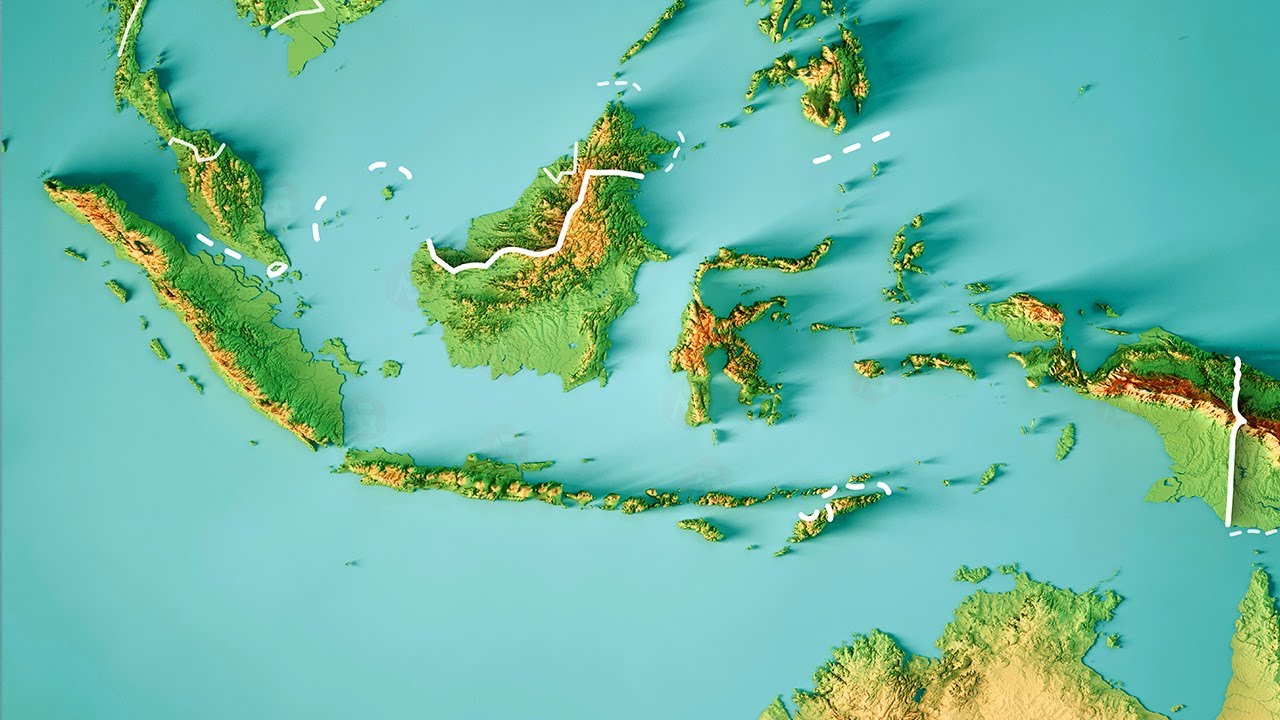
TLDRThe geographical conditions of Indonesia are characterized by its vast archipelago, consisting of over 17,000 islands, which makes it the largest island nation in the world. This strategic location between the Pacific and Indian Oceans creates a diverse climate and rich natural resources, supporting a variety of ecosystems and biodiversity. Indonesia’s geography also presents challenges such as volcanic activity, earthquakes, and an extensive coastline. These factors contribute to both the opportunities and challenges faced by the country.
Takeaways
- 😀 Indonesia is an archipelago consisting of over 17,000 islands, making it the largest archipelagic country in the world.
- 🌍 Indonesia is located in Southeast Asia, between the Indian and Pacific Oceans, giving it strategic geographic significance.
- 🌋 Indonesia is part of the Pacific 'Ring of Fire,' known for its high level of volcanic activity and frequent earthquakes.
- 🏞️ The country features diverse landscapes, including tropical rainforests, mountains, and coastal areas.
- 🌿 Indonesia is home to rich biodiversity, containing unique flora and fauna found nowhere else on Earth.
- 🌡️ The climate in Indonesia is tropical, characterized by a hot, humid environment with distinct wet and dry seasons.
- 🌴 Indonesia's geographical location near the equator leads to a high level of sunlight throughout the year, promoting agriculture.
- ⛵ Indonesia has many vital ports and harbors, playing a key role in global maritime trade.
- 🏙️ The islands of Indonesia have a variety of urban centers, with Jakarta being the capital and one of the largest cities in Southeast Asia.
- 💧 Indonesia faces challenges regarding natural resources, including water distribution and sustainable management of its forests and oceans.
Q & A
What is the geographical condition of Indonesia?
-Indonesia is an archipelago, consisting of over 17,000 islands, making it one of the largest island nations in the world. Its geographical position between the Pacific and Indian Oceans contributes to its strategic importance.
How many islands make up Indonesia?
-Indonesia is made up of more than 17,000 islands, though around 6,000 of them are inhabited.
What are the two major oceans surrounding Indonesia?
-Indonesia is surrounded by the Pacific Ocean to the east and the Indian Ocean to the west.
What is the significance of Indonesia's geographical location?
-Indonesia’s location between two major oceans has made it a crucial maritime route for global trade and has contributed to its cultural diversity due to interactions with many different regions.
How does Indonesia's geography impact its climate?
-Indonesia's tropical climate is heavily influenced by its geographical position near the equator, resulting in warm temperatures year-round and significant rainfall, particularly in the monsoon season.
What is the impact of Indonesia's archipelagic geography on transportation?
-Being an archipelago, transportation in Indonesia is primarily reliant on sea and air travel, with extensive ferry services and airports connecting the many islands.
How does Indonesia's geography affect its biodiversity?
-Indonesia’s diverse ecosystems, ranging from coastal areas to rainforests and volcanic mountains, host a wide variety of species, making it one of the most biodiverse countries in the world.
What role do Indonesia's mountains play in its geography?
-Indonesia has many volcanic mountains, which contribute to fertile soil for agriculture, but also pose risks of eruptions and earthquakes due to the country’s location along the Pacific Ring of Fire.
How does Indonesia's geographical location affect its population distribution?
-The majority of Indonesia's population lives on the island of Java, the most fertile and economically developed island, while other islands, like Papua and Sumatra, have less dense populations.
Why is Indonesia considered a strategic geopolitical location?
-Indonesia’s strategic location between the Pacific and Indian Oceans makes it a key player in global shipping routes, influencing both regional and international trade and politics.
Outlines

このセクションは有料ユーザー限定です。 アクセスするには、アップグレードをお願いします。
今すぐアップグレードMindmap

このセクションは有料ユーザー限定です。 アクセスするには、アップグレードをお願いします。
今すぐアップグレードKeywords

このセクションは有料ユーザー限定です。 アクセスするには、アップグレードをお願いします。
今すぐアップグレードHighlights

このセクションは有料ユーザー限定です。 アクセスするには、アップグレードをお願いします。
今すぐアップグレードTranscripts

このセクションは有料ユーザー限定です。 アクセスするには、アップグレードをお願いします。
今すぐアップグレード関連動画をさらに表示
BAGAIMANA KEADAAN INDONESIA DAN LETAK GEOGRAFISNYA

22 April 2025

Budaya Indonesia

LETAK GEOGRAFIS | ASTRONOMIS INDONESIA DAN PENGARUHNYA, PENGERTIAN GARIS BUJUR DAN GARIS LINTANG

Milik Indonesia DIKUASAI MALAYSIA‼️20 tahun lepas, nasib kini Pulau Sipadan & Ligitan

Karakteristik Geografis Wilayah Indonesia | IPS SD
5.0 / 5 (0 votes)
