CONTINENTAL DRIFT THEORY | SCIENCE 10 - Week 8 Part I
Summary
TLDRThis educational video delves into the concept of continental drift, highlighting Alfred Wegener's theory that all continents were once part of a supercontinent, Pangaea. Evidence supporting this includes the fitting shapes of continents like South America and Africa, unique fossil distributions across now-separated landmasses, matching rock formations, glacial striations in tropical regions, and coal deposits suggesting past tropical climates. The video aims to enhance understanding of Earth's geological history and the dynamic nature of its landmasses.
Takeaways
- 🌐 The concept of continental drift suggests that the Earth's continents were once part of a single landmass.
- 🧩 Alfred Wegener's theory of continental drift was initially based on the observation that the continents' shapes fit together like a puzzle.
- 📚 Wegener's book, 'The Origin of Continents and Oceans', laid out the foundational ideas for the continental drift theory.
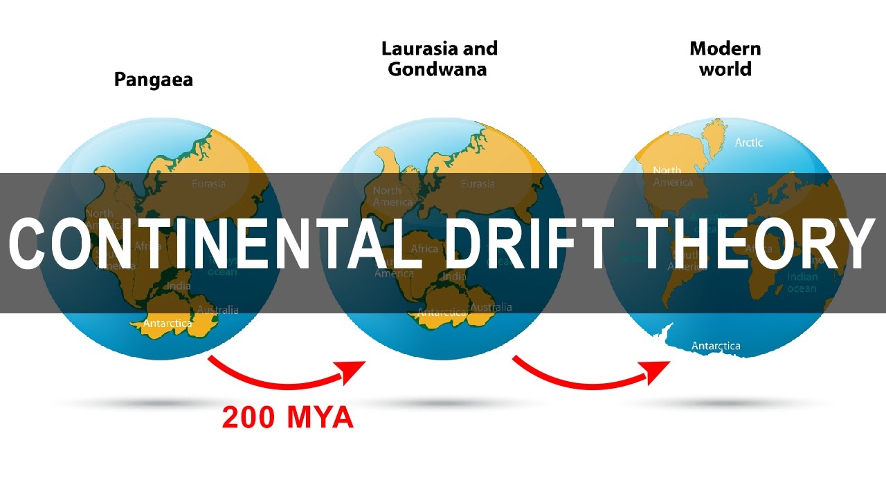
- 🌍 Pangea, meaning 'all earth', was the proposed supercontinent that existed around 200 million years ago, surrounded by the mega ocean, Panthalassa.
- 🔍 The theory of plate tectonics, published in 1965, provided the mechanism that explained how continents moved, thus supporting Wegener's theory.
- 🌿 Fossil evidence, such as the distribution of Glossopteris plants and Mesosaurus reptiles, supports the idea that continents were once connected.
- 🏔 Rock formations, like the Cape Mountains in South America and Africa, show alignment that suggests these continents were once a single landmass.
- ❄️ Glacial striations found in regions like South America and Africa, which are now tropical, indicate they were once in colder climates near the South Pole.
- 🌿 Coal deposits in Antarctica and other continents suggest that these areas once had a much warmer climate and were located closer to the equator.
- 🔬 The lesson concludes that the evidence from fossils, rock formations, glacial striations, and coal deposits collectively supports the continental drift theory.
Q & A
What is the main focus of the discussion in the provided transcript?
-The main focus of the discussion is the learning competency related to plate movement, specifically the continental drift theory and the evidences that support it.
What are the three key takeaways from the lesson on continental drift theory?
-The three key takeaways are: 1) Describing the continental drift theory, 2) Tracing the geologic formation of continents within the continental drift theory, and 3) Explaining the evidences that support the continental drift theory.
What observation about the world map led to the development of the continental drift theory?
-The observation that the shapes of landmasses seem to fit together like a puzzle, particularly the continents of South America and Africa, led to the development of the continental drift theory.
Who proposed the continental drift theory and in which book did he lay out his case?
-Alfred Wegener proposed the continental drift theory and he laid out his case in his book 'The Origin of Continents and Oceans'.
What was the name of the supercontinent that Alfred Wegener proposed existed 200 million years ago?
-The supercontinent that Alfred Wegener proposed existed 200 million years ago was named Pangea, which means 'all earth'.
What were the two smaller supercontinents that Pangea broke into according to Wegener's theory?
-According to Wegener's theory, Pangea broke into two smaller supercontinents: Laurasia in the north and Gondwanaland in the south.
What are the four main lines of evidence that support the continental drift theory mentioned in the transcript?
-The four main lines of evidence supporting the continental drift theory mentioned are: 1) Continental jigsaw puzzle, 2) Fossil evidence, 3) Rock formations, and 4) Glacial striations.
How do the fossil evidences, such as Mesosaurus and Glossopteris, support the continental drift theory?
-Fossil evidences like Mesosaurus and Glossopteris, which are found in continents now separated by oceans, support the continental drift theory by indicating that these continents were once connected.
What do glacial striations indicate about the past geographical positions of South America and Africa?
-Glacial striations in the present-day tropical rainforests of South America and Africa indicate that these regions were once located in colder areas, such as near the South Pole, supporting the idea that they were part of a connected landmass.
How do coal deposits in Antarctica suggest past climatic and geographical changes?
-The presence of coal deposits in Antarctica, which currently cannot sustain substantial life, suggests that it once experienced a tropical climate and was positioned closer to the equator, indicating past climatic and geographical changes.
What does the alignment of rock formations in Africa and South America suggest about the past?
-The alignment of rock formations in Africa and South America suggests that these continents were once part of a single, continuous landmass, supporting the continental drift theory.
Outlines
🌍 Continental Drift Theory Overview
This paragraph introduces the concept of continental drift, a theory that explains the movement of Earth's landmasses. It highlights the observation that continents seem to fit together like pieces of a puzzle, suggesting they were once part of a larger landmass. The theory was proposed by Alfred Wegener, who suggested that around 200 million years ago, all continents were part of a single supercontinent named Pangaea. Wegener's theory was not widely accepted until the 1960s with the advent of plate tectonics. The paragraph also mentions the three learning competencies: describing continental drift theory, tracing the geologic formation of continents, and explaining evidences supporting the theory.
🔍 Evidences Supporting Continental Drift
This paragraph delves into the various lines of evidence that support the theory of continental drift. It discusses the 'jigsaw puzzle' of continents, where the shapes and edges of continents like South America and Africa align perfectly, suggesting they were once connected. Fossil evidence is also presented, with unique distribution patterns of fossils like Mesosaurus and Glossopteris found on continents now separated by oceans, indicating they were once part of the same landmass. The paragraph further explores rock formations that align across continents, glacial striations found in regions that are now tropical but were once glaciated, and the presence of coal deposits in Antarctica, suggesting it was once in a warmer climate closer to the equator. These evidences collectively support the idea of continental drift and the movement of Earth's landmasses.
Mindmap
Keywords
💡Continental Drift Theory
💡Pangaea
💡Laurasia
💡Gondwanaland
💡Fossils
💡Mesosaurus
💡Glacial Striations
💡Coal Deposits
💡Geologic Formation
💡Plate Tectonics
💡Continental Jigsaw Puzzle
Highlights
Learning competency focuses on understanding plate movement and continental drift theory.
Three main objectives: describe continental drift theory, trace geologic formation of continents, and explain supporting evidences.
Observation of landmass shapes fitting together like a puzzle led to the continental drift theory.
Alfred Wegener proposed the continental drift theory in his book 'The Origin of Continents and Oceans'.
Wegener's theory suggested a single large landmass, Pangaea, surrounded by a mega ocean, Panthalassa.
Pangaea broke into two smaller supercontinents, Laurasia and Gondwanaland, during the Jurassic period.
Continental drift theory was not widely accepted until the 1965 publication of plate tectonics theory.
The continental jigsaw puzzle is the most visible evidence of continental drifting.
Fossils provide unique distribution patterns that support the idea of connected continents.
Fossilized leaves of an extinct plant, Glossopteris, were found across now-separated continents.
Mesosaurus, a freshwater reptile, indicates that South America and Africa were once connected.
Rock formations in Africa and South America align as if they were once part of the same mountain range.
Glacial striations in South America and Africa suggest these areas were once in colder climates.
Coal deposits in Antarctica imply it once had a tropical climate and was closer to the equator.
Lesson concludes with a summary of the evidences supporting continental drift theory.
Transcripts
[Music]
our discussion will focus on the
learning competency
enumerate the lines of evidence that
support plate movement
at the end of the lesson you should be
able to one
describe continental drift theory number
two trace the geologic formation of
continents in the continental drift
theory
and number three explain evidences that
support continental
drift theory everybody have seen the map
of the world
but if you will take a closer look at
the shapes of each landmass
you will notice that they seem to fit
together like a puzzle
that if you are going to put each
continents close to each other
you will actually create a giant
landmass
let's say for example the continents of
south america
may seem to fit together with africa
can you see it
this observation actually led to one of
the theories that
explained earth movement known as the
continental drift theory
this theory was proposed by alfred
budgener
he laid out his case in his book the
origin of continents and ocean
he proposed a theory that about 200
million years ago
the continents were once one large
landmass
however wedgener could not explain what
force was driving the motion of the
continents
his theory was not accepted by the
scientific community until 1965 when the
theory of blade tectonics was published
according to wedgener all continents
formed a single continental mass
this supercontinent was named panjaya or
panjei
which means all earth this was
surrounded by a mega ocean
called pantalasa meaning
all water wagener argued that around 200
million years ago
this supercontinent pangea started to
break into two smaller super continents
called laurasia in the north and
gondwanaland
in the south during the jurassic period
these smaller supercontinents broke into
the continents and this continent
separated and drifted apart
since then the illustration shows how
the landmasses drifted in the last 250
million years
to support his claim wagener cited
evidences of continental drifting
first is the continental jigsaw puzzle
the most visible and fascinating
evidence
that these continents were once one in
their shapes
if you will cut out pictures of each
continent and bring them close together
you will see that the edge of continent
surprisingly matches the edge of another
south america and africa fit together
india antarctica and australia match one
another
and eurasia and north america complete
the whole continental puzzle in the
north
next is the evidence from fossils
fossils are preserved remains or traces
of organisms from the remote past
fossils have unique distribution
patterns in some parts of the world
mesosoros cynonatus listosaurus and
glossopteries are the notable ones
fossilized leaves of an extinct plant
gloss of terrace were found in 250
million years old rocks
these fossils were located in the
continents of south africa
australia india and antarctica which are
now separated from each other by
wide oceans the large seeds of this
plant could not possibly travel a long
journey
by the wind or survive a rough ride
through the ocean waves
fossils of mesosoros a freshwater
reptile was found in the eastern coast
of south america
and western coast of africa according to
wedgener
while mesosaurus roamed the land these
continents were connected
but after they become extinct the
continents were torn apart
rocks also provide evidence that
continents drifted apart
rock formations in africa lined up with
that in south
america as if it was a long mountain
range
folded cape mountains of south america
and africa
line up perfectly as if they were once a
long mountain range
another evidence is the glacial
striations
glaciers can only be found in cold
places of the earth
like the north and south pole of the
earth something interesting about
glaciers
is that they move and when they move
over the rock beneath
they leave evidence in the form of
scratch called
glacial striation in the present day
tropical rainforests of south america
and africa
have glacial striations
this means that this place were not
always in their warm equatorial regions
like they are
now they were once down in the south
pole where they have been cold enough to
form glaciers
and we have the coal deposits coal beds
were formed from the compaction in the
composition of swamp plants that
lived millions of years ago this were
discovered in south america
africa indian subcontinent south east
asia and even in antarctica
the current location of antarctica could
not sustain substantial amount of life
if there is substantial quantity of coal
in it
it only means that antarctica must have
been positioned in a part of the earth
where it once supported large quantities
of life
this leads to the idea that antarctica
once experienced a tropical climate
thus it might have been closer before to
the equator
and that ends our lesson i hope you
learned something today
thank you for watching
5.0 / 5 (0 votes)