Araling Panlipunan 8 MATATAG Q1 Week 1-2 Mga Teorya sa Pagkakabuo ng mga Kontinente with PPT and DLL
Summary
TLDRThis video explores the fascinating theories behind the formation of Earth's continents. It explains Alfred Wegener's Continental Drift Theory, which posits that all continents were once part of the supercontinent Pangea, and the Plate Tectonics Theory, which details how the Earth's crust, divided into tectonic plates, moves over the mantle to shape the surface. The video also covers how latitude and longitude help determine the locations of places and their climates, and introduces Vladimir Köppen's classification of climate types based on temperature and precipitation. This educational content ties Earth's physical processes to its diverse environments.
Takeaways
- 😀 The Earth has seven continents: Asia, Africa, North America, South America, Antarctica, Europe, and Australia.
- 😀 Continental Drift Theory, proposed by Alfred Wegener in 1912, suggests that continents were once part of a single landmass called Pangea.
- 😀 Pangea split into two landmasses: Laurasia (Asia, Europe, North America) and Gondwanaland (Africa, Antarctica, Australia, South America).
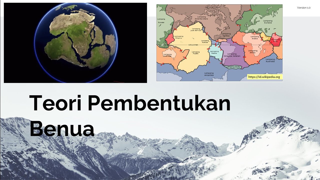
- 😀 Plate Tectonics Theory, developed in the 1960s, explains that continents rest on tectonic plates that float on the Earth's mantle.
- 😀 The Earth's crust consists of large tectonic plates that move due to convection currents in the mantle, leading to the formation of mountains, earthquakes, and ocean trenches.
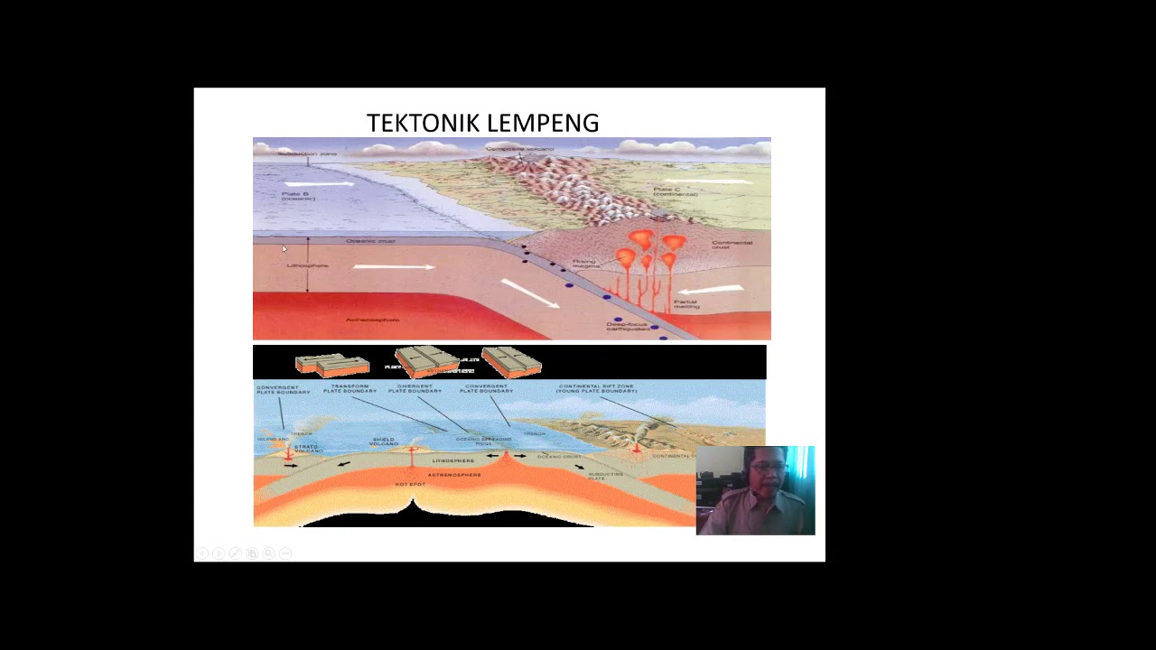
- 😀 The movement of tectonic plates occurs at three boundary types: divergent, convergent, and transform.
- 😀 Divergent boundaries cause plates to move apart, forming valleys or ocean ridges.
- 😀 Convergent boundaries occur when plates collide, leading to mountain formation or subduction, creating trenches.
- 😀 Transform boundaries involve plates sliding past one another, often causing earthquakes.
- 😀 Latitude and longitude are used to determine the exact location of places on Earth, with latitude measuring distance north or south of the equator and longitude measuring distance east or west of the Prime Meridian.
- 😀 Climate is influenced by a location's latitude, with regions near the equator being hot, polar regions cold, and mid-latitudes having moderate climates. Vladimir Köppen classified five major climate types based on temperature and precipitation.
Q & A
What is the largest land mass on Earth's surface?
-The largest land mass on Earth's surface is called a continent. The continents of the world are Asia, Africa, North America, South America, Antarctica, Europe, and Australia.
What does the theory of Continental Drift propose?
-The theory of Continental Drift, proposed by Alfred Wegener in 1912, suggests that the continents were once a single landmass called Pangea. Over time, they drifted apart due to the movement of Earth's surface and continue to move today.
What was Pangea and what did it break into?
-Pangea was a supercontinent that existed millions of years ago. It eventually broke into two large landmasses: Gondwanaland and Laurasia. From these, the continents of Asia, Europe, North America, Africa, Antarctica, Australia, and South America were formed.
What is Plate Tectonics Theory?
-Plate Tectonics Theory, developed in 1960, explains that Earth's continents rest on tectonic plates—large chunks of land floating on the mantle's molten magma. The movement of these plates in three directions shapes the Earth's surface.
What are the three types of plate boundaries?
-The three types of plate boundaries are: 1) Divergent boundaries, where plates move apart, creating valleys or plains. 2) Convergent boundaries, where plates collide, forming mountains or trenches. 3) Transform boundaries, where plates slide past each other, often causing earthquakes.
What are tectonic plates and how do they move?
-Tectonic plates are large pieces of Earth's crust that float on the mantle's semi-fluid layer. These plates move due to the convection currents in the mantle, caused by the heat from the Earth's core.
How are landforms and ocean features created by plate movements?
-Plate movements lead to the creation of various landforms and ocean features. For example, divergent boundaries can form valleys or ridges, convergent boundaries can create mountains or ocean trenches, and transform boundaries can lead to earthquakes.
What role does latitude play in determining climate?
-Latitude plays a crucial role in determining the climate of a region. Areas near the equator (0° latitude) receive more heat from the sun, leading to warmer climates, while regions closer to the poles are colder due to less direct sunlight.
What are the five climate types categorized by Vladimir Köppen?
-Vladimir Köppen classified climates into five main types based on temperature and precipitation: 1) Tropical (hot and humid), 2) Dry (hot and dry), 3) Temperate (moderate), 4) Continental (hot summers, cold winters), and 5) Polar (always cold).
How does the position of a place affect its climate?
-The position of a place, particularly its latitude and distance from the equator, greatly affects its climate. Areas closer to the equator tend to be hotter, while areas further away experience colder temperatures. Wind direction, ocean currents, and elevation also influence local climates.
Outlines

This section is available to paid users only. Please upgrade to access this part.
Upgrade NowMindmap

This section is available to paid users only. Please upgrade to access this part.
Upgrade NowKeywords

This section is available to paid users only. Please upgrade to access this part.
Upgrade NowHighlights

This section is available to paid users only. Please upgrade to access this part.
Upgrade NowTranscripts

This section is available to paid users only. Please upgrade to access this part.
Upgrade Now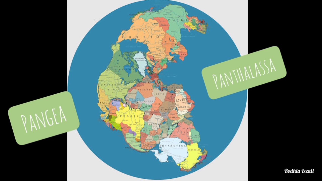


5.0 / 5 (0 votes)