Latitude and Longitude

Andy Jensen
14 Jan 201003:14

Summary

TLDRThe video script explores the concept of locating places on Earth using a grid system of latitude and longitude. It explains how latitude lines, or parallels, circle the globe at equal intervals of about 69 miles, and are further divided into minutes and seconds. The script also discusses significant lines of latitude, such as the Tropic of Cancer, Tropic of Capricorn, and the Arctic and Antarctic Circles, which define the Earth's climatic zones. Longitude lines, or meridians, run from pole to pole, intersecting at the poles, and are measured from the Prime Meridian. The script uses the Coronado Bridge in San Diego as an example to illustrate how coordinates can precisely pinpoint a location on Earth.

Takeaways

  • 🌍 Earth is our home in the vast universe, with a circumference of nearly 25,000 miles.
  • 📍 Locating specific places on Earth can be challenging without a precise system of coordinates.
  • 🌐 The invisible grid of latitude and longitude helps in pinpointing exact locations on Earth.
  • 🔄 Latitude lines, also known as parallels, circle the Earth from east to west, equidistantly spaced at about 69 miles apart per degree.
  • ⏱ Each degree of latitude is further divided into 60 minutes, and each minute into 60 seconds for more precise location.
  • 🌡 The equator is at 0 degrees latitude, with the Tropic of Cancer at 23.5 degrees north and the Tropic of Capricorn at 23.5 degrees south, defining the tropics.
  • 🌨 The area between the tropics experiences hot temperatures, heavy rainfall, and dense jungle, while the temperate zones have four distinct seasons.
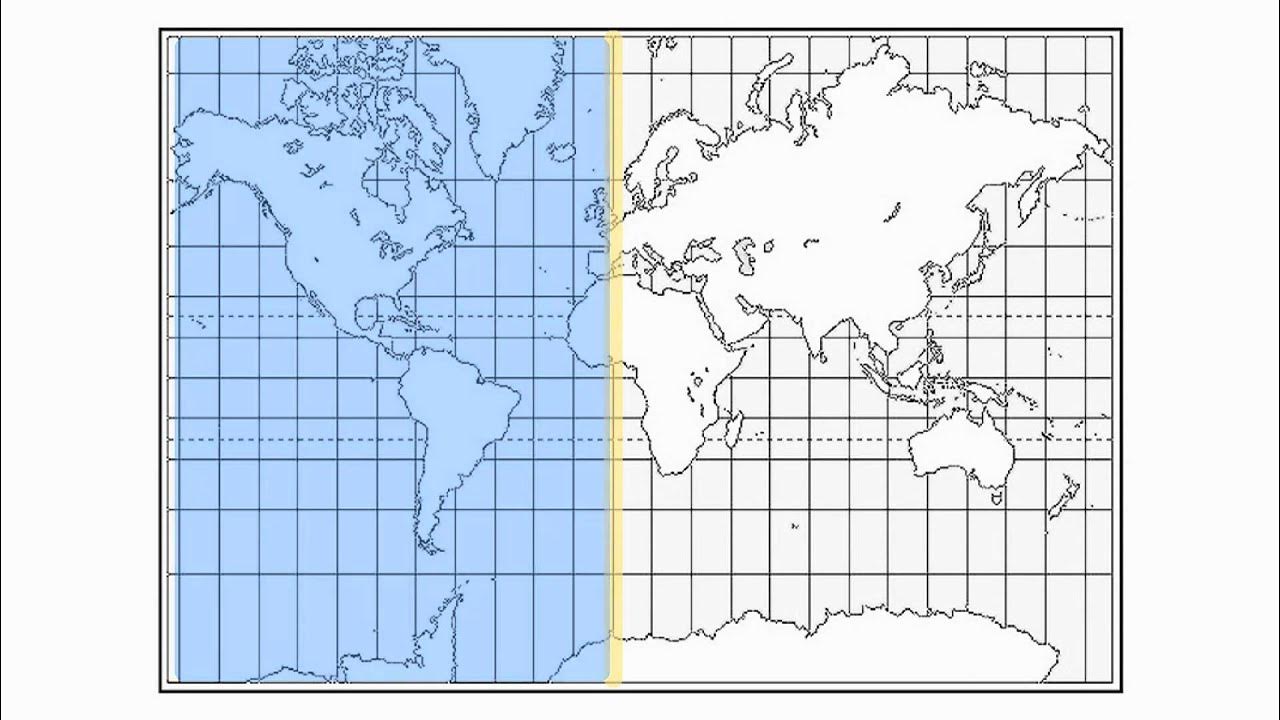
  • 🌐 Longitude lines, or meridians, run from north to south, intersecting at the poles, and are measured in degrees, minutes, and seconds like latitude.
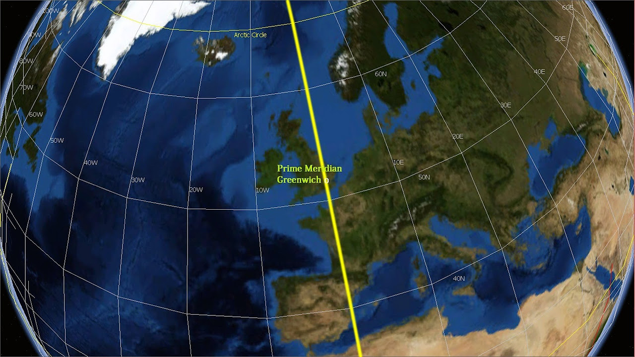
  • 📡 The prime meridian at 0 degrees longitude passes through the Royal Greenwich Observatory in England, serving as the reference point for longitude.
  • 📌 San Diego's precise location can be expressed as 32 degrees 42 minutes 54 seconds north latitude and 117 degrees 9 minutes 25 seconds west longitude.

Q & A

  • What is the approximate circumference of the Earth?

    -The Earth's circumference is nearly 25,000 miles.

  • How can one precisely locate a specific place on Earth like the Coronado Bridge in San Diego?

    -One can precisely locate a place by providing its coordinates, which include latitude and longitude.

  • What are the lines that circle the globe from east to west called?

    -The lines that circle the globe from east to west are called lines of latitude or parallels.

  • What is the distance between each degree of latitude?

    -Each degree of latitude is separated by approximately 69 miles.

  • How are degrees of latitude further divided?

    -Each degree of latitude is divided into smaller pieces called minutes, with 60 minutes in one degree.

  • What is the significance of the equator in terms of latitude?

    -The equator lies at 0 degrees latitude and is the starting point for measuring latitude, with the North and South Poles being the endpoints.

  • What are the Tropic of Cancer and Tropic of Capricorn, and what is the area between them called?

    -The Tropic of Cancer lies at 23.5 degrees north, and the Tropic of Capricorn lies at 23.5 degrees south. The area between these lines is called the tropics.

  • What is the climate characteristic of the tropics?

    -The tropics are known for hot temperatures, heavy rainfall, and dense jungle.

  • What are the Arctic and Antarctic Circles, and what do they signify?

    -The Arctic Circle lies at 66.5 degrees north, and the Antarctic Circle lies at 66.5 degrees south. They mark the boundaries of the areas that experience four distinct seasons.

  • How are longitude lines measured and what are they called?

    -Longitude lines are measured in degrees, minutes, and seconds and are called meridians of longitude.

  • How do meridians of longitude differ from parallels of latitude?

    -Unlike latitude lines, which are equidistant, longitude lines converge at the poles and are not equidistant from each other.

  • What is the prime meridian and where does it pass through?

    -The prime meridian is at 0 degrees longitude and passes through the Royal Greenwich Observatory in Greenwich, England.

  • How can the precise location of San Diego be described using latitude and longitude?

    -The precise location of San Diego can be described as 32 degrees 42 minutes 54 seconds north latitude and 117 degrees 9 minutes 25 seconds west longitude.

Outlines

00:00

🌐 Understanding Earth's Coordinate System

This paragraph introduces the concept of locating specific places on Earth using a grid system of latitude and longitude. It explains that Earth's circumference is approximately 25,000 miles and that to find a precise location, such as the Coronado Bridge in San Diego, one can use coordinates. The paragraph then delves into the details of the grid system, describing latitude lines, also known as parallels, which circle the globe from east to west at equal intervals of about 69 miles apart. Each degree of latitude is further divided into 60 minutes and each minute into 60 seconds. The equator is at 0 degrees, with the Tropic of Cancer at 23.5 degrees north and the Tropic of Capricorn at 23.5 degrees south, defining the tropics. The Arctic and Antarctic Circles are at 66.5 degrees north and south, respectively, and the area between these circles experiences four distinct seasons. The paragraph also explains that longitude lines, or meridians, run from north to south and intersect at the poles. The Prime Meridian at 0 degrees longitude passes through the Royal Greenwich Observatory in England. The precise location of San Diego is given as an example, with its coordinates in degrees, minutes, and seconds of latitude and longitude.

Mindmap

Keywords

💡Circumference

Circumference refers to the total distance around a circle or spherical object. In the context of the video, the Earth's circumference is mentioned as nearly twenty-five thousand miles, emphasizing the vastness of our planet and setting the stage for the discussion on how to locate specific places on Earth.

💡Coordinates

Coordinates are a set of numerical values that define a point in space. The video explains that to precisely locate a place like the Coronado Bridge in San Diego, one would give its coordinates, which are based on latitude and longitude. This concept is central to the video's theme of geographic positioning.

💡Latitude

Latitude is the angular distance of a point on the Earth's surface, measured in degrees north or south from the Equator. The video describes how lines of latitude, also known as parallels, circle the globe and are crucial for determining locations. It also mentions specific latitude lines like the Tropic of Cancer and the Arctic Circle.

💡Longitude

Longitude is the angular distance of a point on the Earth's surface, measured in degrees east or west from the Prime Meridian. The video explains that meridians of longitude, unlike latitude lines, are not equidistant from each other and intersect at the poles. Longitude is essential for pinpointing precise locations on Earth.

💡Equator

The Equator is an imaginary line on the Earth's surface at 0 degrees latitude, dividing the planet into the Northern and Southern Hemispheres. The video uses the Equator as a reference point to discuss the division of the Earth into latitude zones and the concept of degrees of latitude.

💡Tropic of Cancer

The Tropic of Cancer is a line of latitude at approximately 23.5 degrees north of the Equator. The video mentions this line as a boundary within the tropics, an area known for hot temperatures, heavy rainfall, and dense jungles. It's an example of how specific latitude lines help define Earth's climatic zones.

💡Tropic of Capricorn

The Tropic of Capricorn is a line of latitude at approximately 23.5 degrees south of the Equator. Similar to the Tropic of Cancer, it is mentioned in the video to illustrate the division of the Earth into climatic zones and to define the boundaries of the tropics.

💡Arctic Circle

The Arctic Circle is a line of latitude at approximately 66.5 degrees north of the Equator. The video describes it as a boundary for the region characterized by four distinct seasons, highlighting how latitude lines influence climate and environmental conditions.

💡Antarctic Circle

The Antarctic Circle is a line of latitude at approximately 66.5 degrees south of the Equator. The video briefly mentions it in the context of defining the Earth's climatic zones, similar to the Arctic Circle but in the Southern Hemisphere.

💡Prime Meridian

The Prime Meridian is the meridian (line of longitude) at 0 degrees, which passes through the Royal Greenwich Observatory in Greenwich, England. The video uses it as a reference for the starting point of all longitude measurements, essential for understanding the global grid system of longitude.

💡Grid System

The grid system mentioned in the video refers to the network of latitude and longitude lines that cover the Earth's surface. This invisible grid allows for the precise location of any point on Earth, such as the example given for San Diego, by using degrees, minutes, and seconds.

Highlights

Earth is our home in the vast universe.

Earth's circumference is nearly twenty-five thousand miles.

Locating precise locations on Earth can be challenging.

Describing the exact location of the Coronado Bridge in San Diego is an example of such a challenge.

Providing coordinates makes it easier to find specific locations.

Latitude and longitude form an invisible grid over the Earth for precise location.

Latitude lines, also known as parallels, circle the globe from east to west.

Each degree of latitude is 69 miles apart.

Latitude is divided into smaller units called minutes and seconds.

The equator is at 0 degrees latitude.

The Tropic of Cancer and Capricorn are at 23.5 degrees north and south.

The area between the tropics is known for hot temperatures and heavy rainfall.

The Arctic and Antarctic Circles are at 66.5 degrees north and south.

The area between the circles and the tropics experiences four distinct seasons.

Longitude lines run north and south and are called meridians.

Longitude is measured in degrees, minutes, and seconds like latitude.

Meridians are not equidistant from each other, unlike latitude lines.

The prime meridian at 0 degrees longitude passes through the Royal Greenwich Observatory.

San Diego's precise location is given by its latitude and longitude coordinates.

The invisible grid of latitude and longitude allows us to pinpoint locations on Earth.

Transcripts

play00:03

earth our home in the vast universe the

play00:08

Earth's circumference is nearly twenty

play00:10

five thousand miles from start to finish

play00:12

there are so many places on the earth

play00:14

how is it possible to precisely locate

play00:16

just one of them for instance what if I

play00:21

wanted to tell a friend the exact

play00:22

location of the Coronado Bridge in San

play00:24

Diego it would be hard to describe but

play00:28

give him the coordinates of the bridge

play00:30

and he should be able to find it quite

play00:32

easily to find precise locations

play00:35

parallels of latitude and meridians of

play00:38

longitude form an invisible grid over

play00:41

the earth latitude lines of latitude

play00:46

also known as parallels circle the globe

play00:49

from east to west these lines are all

play00:52

the same distance apart about 69 miles

play00:55

each degree of latitude is separated

play00:58

into smaller pieces called minutes there

play01:01

are 60 minutes and one degree similarly

play01:04

each minute is divided into 60 seconds

play01:08

the equator lies at 0 degrees halfway in

play01:12

between the North and South Poles there

play01:15

are several other unique lines of

play01:16

latitude the Tropic of Cancer lies at 23

play01:20

and 1/2 degrees north and the Tropic of

play01:22

Capricorn lies at 23 and 1/2 degrees

play01:24

south the part of the earth that lies

play01:27

between these lines is called the

play01:29

tropics it's known for its hot

play01:31

temperatures heavy rainfall and dense

play01:33

jungle the Arctic Circle lies at 66 and

play01:37

1/2 degrees north and the Antarctic

play01:40

Circle lies at 66 and 1/2 degrees south

play01:42

the area of the earth between these

play01:45

parallels and the tropics is

play01:46

characterized by four distinct seasons

play01:53

longitude the lines that run north and

play01:57

south are called meridians of longitude

play01:59

these lines are measured the same way as

play02:02

parallels of latitude using degrees

play02:04

minutes and seconds

play02:05

however unlike latitude lines of

play02:09

longitude are not equidistant from each

play02:11

other

play02:12

meridians intersect at the north and

play02:14

south pole 0 degrees longitude is called

play02:18

the prime meridian it passes through the

play02:21

Royal Greenwich Observatory in Greenwich

play02:23

England using latitude and longitude the

play02:27

precise location of San Diego can be

play02:29

written as 32 degrees 42 minutes 54

play02:34

seconds north latitude 117 degrees 9

play02:38

minutes 25 seconds west longitude

play02:45

parallels of latitude and meridians of

play02:48

longitude form an invisible grid over

play02:50

the earth this grid is measured in

play02:53

degrees minutes and seconds and it

play02:55

allows us to pinpoint exactly where on

play02:59

the face of the earth

play03:10

you

play03:11

you

Rate This

5.0 / 5 (0 votes)

الوسوم ذات الصلة
GeographyCoordinatesEarth GridNavigationLatitudeLongitudeTropicsArctic CircleAntarctic CircleExplorationLocation
هل تحتاج إلى تلخيص باللغة الإنجليزية؟