Rangkuman Materi: Penginderaan Jauh
Summary
TLDRThis video lesson covers remote sensing (penginderaan jauh), explaining its definition, components, and applications. It introduces key concepts such as the different types of platforms (like drones, planes, and satellites), energy sources (active vs. passive), and sensors (photographic and electronic). The video also discusses image types, including photo and non-photo images, as well as data acquisition methods. Key elements such as atmospheric layers, data interpretation, and the various fields that use remote sensing (military, mapping, climate, etc.) are also explored, providing a comprehensive understanding of remote sensing technologies and their real-world uses.
Takeaways
- 😀 Remote sensing is the science and art of acquiring information about objects, regions, or phenomena without direct contact.
- 😀 There are nine key components of remote sensing: platform, energy source, sensor, image, non-photo image, atmosphere, data acquisition, and data interpretation.
- 😀 Platforms used in remote sensing include drones, balloons, aircraft, and satellites, classified by altitude: low (1-9 km), high (>18 km), and satellite (400-900 km).
- 😀 Energy sources in remote sensing are either passive (using sunlight) or active (using artificial sources like microwaves), influenced by factors like time, surface form, and weather conditions.
- 😀 Sensors are devices mounted on platforms to capture data; they can be photographic (recording images via chemical processes) or electronic (using electric signals processed into digital data).
- 😀 Images captured through remote sensing can be classified into photo images and non-photo images, with further categories based on electromagnetic spectrum (ultraviolet, infrared, etc.).
- 😀 Photos can be vertical (orthophoto) or oblique (angled), distinguished by whether the sky is visible, with low oblique photos showing the sky and high oblique photos showing no sky.
- 😀 Image types also include true color (natural color) and false color (unnatural colors), used for different types of analysis.
- 😀 Non-photo images include thermal infrared and radar images, with single-sensor and multispectral classifications based on the number of sensors used.
- 😀 Remote sensing data is analyzed through manual interpretation using tools like stereoscopes or through digital means using specialized software, with various applications in fields like military, population studies, mapping, and meteorology.
Q & A
What is remote sensing?
-Remote sensing is the science and art of acquiring information about objects, areas, or phenomena through the analysis of data collected by instruments without direct contact with the object or area being studied.
What are the nine components of remote sensing?
-The nine components of remote sensing are: Platform (Wahana), Energy Source, Sensor, Image (Citra), Non-photo Image, Atmosphere, Data Acquisition, Data Interpretation, and Data Usage.
What is the role of the platform in remote sensing?
-The platform, or 'Wahana,' is the vehicle or medium used to carry the sensor for collecting remote sensing data. Examples include drones, balloons, airplanes, and satellites.
How is energy source categorized in remote sensing?
-The energy source in remote sensing is categorized into passive systems, which use sunlight, and active systems, which use artificial energy sources like microwaves.
What types of sensors are used in remote sensing?
-Sensors in remote sensing are categorized into two types: photographic sensors, which record objects through chemical processes (producing aerial photos or satellite images), and electronic sensors, which record data in electrical signals that can be processed into visual or digital data.
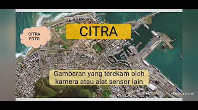
What are the differences between photo images and non-photo images in remote sensing?
-Photo images (Citra foto) are captured using a camera sensor, while non-photo images (Citra nonfoto) are captured using non-camera sensors, such as infrared or radar sensors.
What are the different types of photo images in remote sensing?
-Photo images in remote sensing can be categorized by light spectrum, such as ultraviolet photos, orthochromatic photos, panchromatic photos, and infrared photos. They can also be classified based on the camera angle: vertical (Orto F) or oblique (oblique photography, low or high).
How does the atmosphere impact remote sensing?
-The atmosphere can affect remote sensing by filtering electromagnetic energy. It has a 'window' where certain wavelengths, like sunlight, can pass through, affecting the quality and accuracy of the data collected.
What is the role of data interpretation in remote sensing?
-Data interpretation in remote sensing involves analyzing the captured images to identify features based on spatial, spectral, and temporal characteristics such as shape, size, texture, pattern, and color.
What are the different types of data used in remote sensing?
-Remote sensing data can be classified into manual data, which is interpreted visually, and numerical or digital data, which is processed using specialized software.
Outlines

This section is available to paid users only. Please upgrade to access this part.
Upgrade NowMindmap

This section is available to paid users only. Please upgrade to access this part.
Upgrade NowKeywords

This section is available to paid users only. Please upgrade to access this part.
Upgrade NowHighlights

This section is available to paid users only. Please upgrade to access this part.
Upgrade NowTranscripts

This section is available to paid users only. Please upgrade to access this part.
Upgrade Now


5.0 / 5 (0 votes)