COORDENADA GEOGRÁFICA: Paralelos, Meridianos, Latitudes e Longitudes
Summary
TLDRThis video serves as an informative guide to understanding geographic coordinates, focusing on the concepts of parallels, meridians, latitude, and longitude. The presenter explains the purpose of these imaginary lines created to help locate points on Earth. The video delves into the specifics of the equator, tropics, and poles, as well as the meridian of Greenwich. It also clarifies how to determine coordinates, combining latitude and longitude for precise locations. Additionally, the video touches on the finer details, such as the use of minutes and seconds for greater accuracy in pinpointing small locations like stadiums. It's a comprehensive and accessible tutorial for geography students.
Takeaways
- 😀 Parallels are horizontal, imaginary lines that help measure latitude, indicating how far north or south a location is from the Equator.
- 😀 The Earth is divided into two hemispheres: the Northern Hemisphere (north of the Equator) and the Southern Hemisphere (south of the Equator).
- 😀 The Equator is the main parallel and is located at 0° latitude, dividing the Earth into the Northern and Southern Hemispheres.
- 😀 The Tropic of Cancer (23.5° N) and Tropic of Capricorn (23.5° S) mark important latitudes that are close to the Earth's tropics.
- 😀 The Arctic Circle and Antarctic Circle represent the farthest latitudes before reaching the poles.
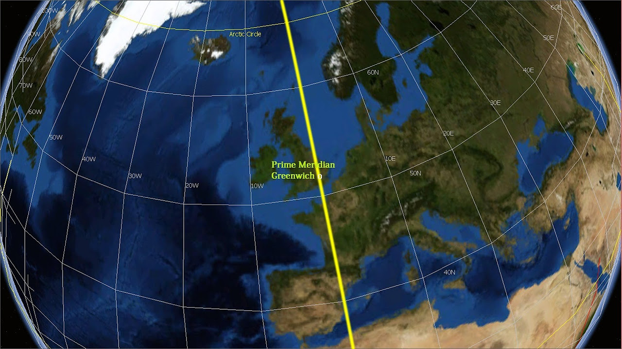
- 😀 Meridians are vertical, imaginary lines that help measure longitude, showing how far east or west a location is from the Prime Meridian.
- 😀 The Prime Meridian is the reference point for longitude, located at 0° and dividing the Earth into the Eastern and Western Hemispheres.
- 😀 Longitude ranges from 0° to 180° both east and west, unlike latitude, which ranges from 0° to 90° north and south.
- 😀 Latitude and longitude are used together to pinpoint any location on Earth through geographical coordinates.
- 😀 The Maracanã Stadium’s precise coordinates are 22°54'43" S latitude and 43°13'48" W longitude, showing how coordinates are used for exact location referencing.
- 😀 Geographical coordinates are expressed in degrees, minutes, and seconds, with a degree being divided into 60 minutes and a minute divided into 60 seconds.
Q & A
What are parallels and meridians?
-Parallels and meridians are imaginary lines created by humans to help us locate positions on Earth's surface. Parallels are horizontal lines, and meridians are vertical lines. Parallels never meet, while meridians intersect at the North and South Poles.
What is the difference between parallels and meridians in terms of their measurements?
-Parallels vary from 0° to 90° north and south of the equator, while meridians range from 0° to 180° east and west of the Prime Meridian.
What is the significance of the equator in terms of parallels?
-The equator is the most important parallel, also called the parallel of zero degrees. It divides the Earth into the Northern and Southern Hemispheres.
How are the hemispheres referred to in geographical terms?
-The Northern Hemisphere can be called 'boreal' or 'septentrional', and the Southern Hemisphere can be referred to as 'austral' or 'meridional'.
What are the five main parallels that have specific names?
-The five main parallels with specific names are: the equator (0°), the Tropic of Cancer (23.5° N), the Tropic of Capricorn (23.5° S), the Arctic Circle (66.5° N), and the Antarctic Circle (66.5° S).
What is the Prime Meridian, and why is it important?
-The Prime Meridian is the meridian at 0° longitude. It is used as the reference for dividing the Earth into Eastern and Western Hemispheres. It passes through Greenwich, London.
What do the terms 'western' and 'eastern' hemispheres refer to?
-The Western Hemisphere is also called the 'occidental' hemisphere, and the Eastern Hemisphere is known as the 'oriental' hemisphere.
What is the relationship between latitude and longitude?
-Latitude measures the distance of a point from the equator (north or south), while longitude measures the distance from the Prime Meridian (east or west).
What are coordinates in geography?
-Geographical coordinates are the precise location of a point on Earth's surface, expressed as the intersection of latitude and longitude. Latitude is listed first, followed by longitude.
Why are minutes and seconds used in geographic coordinates?
-Minutes and seconds are smaller units of measurement used to provide more precise geographic coordinates. One degree equals 60 minutes, and one minute equals 60 seconds.
Outlines

Этот раздел доступен только подписчикам платных тарифов. Пожалуйста, перейдите на платный тариф для доступа.
Перейти на платный тарифMindmap

Этот раздел доступен только подписчикам платных тарифов. Пожалуйста, перейдите на платный тариф для доступа.
Перейти на платный тарифKeywords

Этот раздел доступен только подписчикам платных тарифов. Пожалуйста, перейдите на платный тариф для доступа.
Перейти на платный тарифHighlights

Этот раздел доступен только подписчикам платных тарифов. Пожалуйста, перейдите на платный тариф для доступа.
Перейти на платный тарифTranscripts

Этот раздел доступен только подписчикам платных тарифов. Пожалуйста, перейдите на платный тариф для доступа.
Перейти на платный тарифПосмотреть больше похожих видео


5.0 / 5 (0 votes)
