Differential Leveling Part 2 of 2

Skill Render
14 May 201704:07

Summary

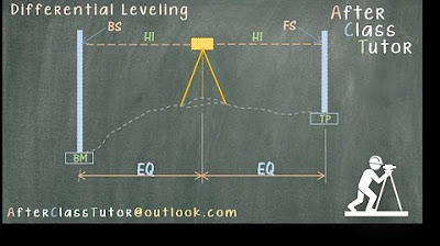
TLDRThis instructional video demonstrates how to calculate elevation at various points using differential leveling. It begins by determining the elevation at station 0+00 using the given benchmark elevation, back sight, and fore sight. The process is repeated for subsequent stations, with the video also showcasing a shortcut for finding the elevation at station 2+00 by using the height of the instrument and subtracting the fore sight. The video concludes with a reminder to subscribe and engage with the content.

Takeaways

  • 📏 The video demonstrates how to determine elevation at various points using differential leveling.
  • 🔱 The process starts by calculating the elevation at station 0+000 using the formula: Elevation at Benchmark + Back Sight at Benchmark - Fore Sight at station.
  • âžĄïž The elevation at subsequent stations is found by adding or subtracting the back and fore sights from the previous station's elevation.
  • 📍 A turning point is introduced, and its elevation is calculated similarly by considering the instrument height and fore sight.
  • 🔄 The method involves iterative steps of adding back sights and subtracting fore sights to find elevations at different stations.
  • 📉 The script provides a shortcut for calculating the elevation at station 2+000 without recalculating from the beginning.
  • 📊 The shortcut involves sketching a diagram and using the known elevation at the Benchmark and back sight to determine instrument height.
  • 📐 The height of the instrument is used to find the elevation at turning points and subsequent stations.
  • 🔱 The final elevation at station 2+000 is calculated to be 102.8 using the shortcut method.
  • 🎓 The video concludes by encouraging viewers to subscribe and leave comments or questions for further engagement.

Q & A

  • What is the main purpose of the video script?

    -The main purpose of the video script is to explain how to determine the elevation at different points using differential leveling techniques.

  • What is the first step in determining the elevation at station 0+000?

    -The first step is to use the equation that involves the elevation at the Benchmark, the back side at the Benchmark, and the foresight at station 0+000.

  • What is the equation used to find the elevation at station 0+000?

    -The equation used is Elevation at 0+000 = Elevation at Benchmark + Back side at Benchmark - Foresight at station 0+000.

  • What is the elevation at station 0+000 according to the script?

    -The elevation at station 0+000 is calculated to be 106.6.

  • How is the elevation at station 0+50 determined?

    -The elevation at station 0+50 is determined by taking the elevation at the Benchmark and adjusting for the back side at the Benchmark and the foresight at station 0+50.

  • What is the process to find the elevation at the Turning Point 1?

    -The elevation at the Turning Point 1 is found by adding the back side at the Benchmark to the elevation at the Benchmark and then subtracting the foresight at the Turning Point.

  • What is the significance of the height of the instrument in the leveling process?

    -The height of the instrument is significant as it helps determine the elevation at different points by being added to the elevation at one point and then subtracting the foresight at the next point.

  • How is the elevation at Station 2+000 calculated using the height of the instrument?

    -The elevation at Station 2+000 is calculated by taking the height of the instrument at the Turning Point and subtracting the foresight at Station 2+000.

  • What is the final elevation at Station 2+000 as per the script?

    -The final elevation at Station 2+000 is 102.8.

  • Why is sketching a diagram helpful in solving the leveling problem?

    -Sketching a diagram is helpful as it visually represents the known elevations and backsight and foresight measurements, aiding in understanding the relationships between different points and simplifying the calculation process.

  • What is the benefit of using the first equation for calculating the elevation at Station 2+000 directly?

    -Using the first equation directly for Station 2+000 simplifies the process by allowing the calculation to be done in one step without needing to calculate intermediate elevations.

Outlines

00:00

📏 Differential Leveling Calculations

The video script explains a method for calculating elevation at different points using differential leveling. It begins with determining the elevation at station 0+000 by using the known elevation at the Benchmark, adding the back sight at the Benchmark, and subtracting the foresight at station 0+000. The process is repeated for subsequent stations, with each station's elevation calculated based on the previous station's elevation, adjusted by the respective back and foresight readings. The script also introduces a shortcut for calculating the elevation at station 2+000 by using the initial equation and plugging in the known values directly, which simplifies the process and avoids unnecessary calculations.

Mindmap

Keywords

💡Differential leveling

Differential leveling is a surveying technique used to determine the relative elevations of different points. It involves measuring the difference in height between a known benchmark and various points of interest. In the video, differential leveling is the main theme, as the script describes a method to calculate the elevation at different stations using this technique.

💡Elevation

Elevation refers to the height of a geographic location above a fixed reference point, usually mean sea level. In the context of the video, elevation is the key parameter being calculated at various stations using differential leveling. The script outlines how to determine the elevation at each point by adding and subtracting measurements taken at benchmarks and stations.

💡Benchmark

A benchmark is a known reference point with a fixed elevation, used as a starting point for leveling and other surveying tasks. In the video, the benchmark is used as the base elevation from which the elevations at other stations are determined. The script uses the benchmark's elevation to calculate the elevations at station 0+00 and other points.

💡Back side

The back side is a measurement taken with a leveling instrument when the telescope is pointed away from the observer towards the benchmark. It is used to correct the line of sight and ensure accurate elevation measurements. In the script, the back side measurement at the benchmark is used in the calculations for the elevation at station 0+00.

💡Fore side

The fore side measurement is taken when the leveling instrument's telescope is pointed towards the point of interest, away from the benchmark. It is used in conjunction with the back side measurement to determine the elevation difference between the benchmark and the point of interest. The script mentions subtracting the fore side measurement from the benchmark's elevation to find the elevation at various stations.

💡Station

In surveying, a station refers to a specific point where measurements are taken. The video script describes a series of stations (0+00, 0+50, Turning Point 1, 1+50, and 2+00) and calculates their elevations using differential leveling. Each station's elevation is determined based on its distance from the benchmark and the fore and back side measurements.

💡Turning point

A turning point is a point in a survey where the direction of leveling changes. It is used to establish a new line of sight for further measurements. In the video, Turning Point 1 is used to calculate the elevation at station 1+50 and is part of the process to determine the elevation at station 2+00.

💡Height of instrument

The height of the instrument is the vertical distance from the benchmark to the point where the leveling instrument is set up. It is crucial for calculating elevation differences. The script explains how to determine the height of the instrument between the benchmark and turning points, which is then used to find the elevation at subsequent stations.

💡Line of sight

The line of sight in surveying is the straight path along which a leveling instrument sights a target. Accurate leveling requires a correct line of sight, which is adjusted using back and fore side measurements. The script implies the importance of the line of sight in ensuring the accuracy of elevation calculations.

💡Instrument

In surveying, an instrument refers to the tools used for taking measurements, such as a leveling instrument. The script mentions the use of an instrument to measure the back and fore sides, which are essential for calculating elevations at different stations.

💡Diagram

A diagram is a visual representation used to illustrate a concept or process. The script suggests sketching a diagram to help understand the process of calculating elevations, especially when determining the elevation at station 2+00. Diagrams are useful for visualizing the relationships between benchmarks, turning points, and stations.

Highlights

Introduction to solving a differential leveling problem to determine elevation at each point.

Using known equations to find elevation at station 0+000.

Equation for elevation at 0+000 involves adding back sight at benchmark and subtracting fore sight at station 0+000.

Calculation example: Elevation at 0+000 is 110 + 3.2 - 6.6 = 106.6.

Method for finding elevation at station 0+050 by using elevation at benchmark and adjusting with back and fore sights.

Elevation at Turning Point 1 is calculated similarly by adding back sight at benchmark and subtracting fore sight at the turning point.

Determining elevation at station 1+050 by adding elevation at turning point and adjusting with back and fore sights.

Final station, 2+000, is calculated by adding elevation at turning point and adjusting with back and fore sights.

Alternative method to find elevation at station 2+000 by sketching a diagram and using known elevation and back sights.

Calculating the height of the instrument between the benchmark and turning point one.

Elevation of turning point one is determined by subtracting fore sight at turning point one from the height of the instrument.

Height of instrument between turning point one and station 2+000 is calculated using a similar method.

Final calculation for elevation at station 2+000 by subtracting fore sight at station 2+000 from the height of the instrument.

Result of elevation at station 2+000 is 102.8.

Using the initial equation for a quick calculation of elevation at station 2+000.

Plugging in the numbers to solve the equation for elevation at station 2+000.

Encouragement to subscribe and leave comments or questions for further engagement.

Transcripts

play00:00

[Music]

play00:12

on this occasion we're going to solve a

play00:14

problem for differential

play00:17

leveling we are going to determine the

play00:19

elevation at each point using the given

play00:22

information first we'll pull out the

play00:25

known equations that we can use to find

play00:27

the known I will start by finding the

play00:30

elevation at station 0 + 0 0 and proceed

play00:35

in that order the equation to determined

play00:38

elevation at 0 + 0 0 is elevation at The

play00:44

Benchmark plus the back side at The

play00:47

Benchmark minus the four side at station

play00:50

0 + 0 0 the equation looks like this

play00:55

elevation at 0 + 0 0 is 110 + 3.2 -

play01:03

6.6 =

play01:06

106.6 similar way for station at 0 + 50

play01:10

we take the elevation at The Benchmark

play01:13

and add the back side at The Benchmark

play01:16

minus the four side at station 0 +

play01:20

50 next the elevation at the Turning

play01:24

point1 is equal to elevation at The

play01:27

Benchmark plus the back side at at The

play01:30

Benchmark minus the four side at the

play01:33

Turning

play01:35

Point the next station is 1 + 50 and the

play01:40

elevation is equal to the elevation at

play01:43

the turning point plus the backside at

play01:45

the Turning Point minus the for side at

play01:49

Station 1 +

play01:53

50 the next and final station is 2 + 0 0

play01:59

the elevation is equal to the elevation

play02:01

at turning point one plus the backs side

play02:05

at the Turning Point minus the for side

play02:08

a Station 2 plus 0

play02:13

0 that is how you calculate each

play02:16

elevation but what if the question was

play02:19

to find elevation at Station 2 +0 we

play02:24

would not have to do all this work

play02:26

instead we could just sketch a diag

play02:30

similar to this along with the given

play02:33

information we know the elevation at The

play02:36

Benchmark and the backside at this same

play02:39

location with this two pieces

play02:42

information we can determine the height

play02:44

of instrument between the Benchmark and

play02:47

the turning point

play02:48

one therefore the height of the

play02:51

instrument is

play02:53

110 plus 3.2 and that gives us

play03:00

now the elevation of Turning Point one

play03:03

is the height of the instrument minus

play03:06

the for side at turning point one the

play03:10

height of instrument between turning

play03:12

point one and Station 2 plus 0 0 is

play03:15

determined in a similar way as we

play03:18

previously did for the last

play03:21

segment finally we take the height of

play03:23

instrument and subtract the for side EST

play03:26

Station 2 plus 0 0 this will equal to

play03:31

102.8 and this is our elevation at

play03:34

Station 2

play03:36

+0 a short way of calculating the

play03:39

elevation at Station 2 plus 0 0 is by

play03:42

using the first equation that we pulled

play03:44

out at the

play03:46

beginning the equation will look as

play03:48

follows just for this specific

play03:52

location now we just plug in the numbers

play03:55

and

play03:55

[Music]

play03:56

solve we hope that this was helpful

play04:00

and please do not forget to subscribe or

play04:03

leave any comments or questions thank

play04:05

you for watching

Rate This
★
★
★
★
★

5.0 / 5 (0 votes)

Étiquettes Connexes
Differential LevelingSurveyingElevation CalculationEngineeringBenchmarkBackside ReadingForeside ReadingSurvey TechniquesLand SurveyHeight Measurement
Besoin d'un résumé en anglais ?