Press Briefing: Tropical Storm #FerdiePH {BEBINCA} - 5:00AM Update September 14, 2024 - Saturday
Summary
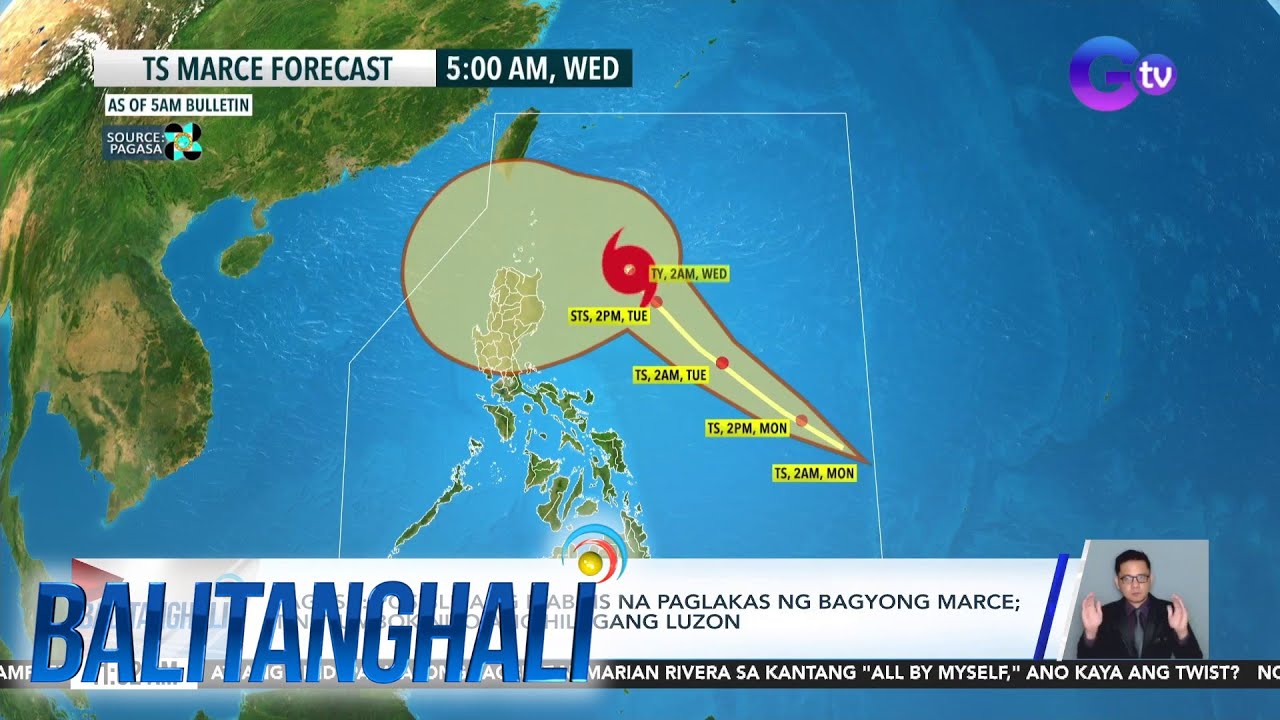
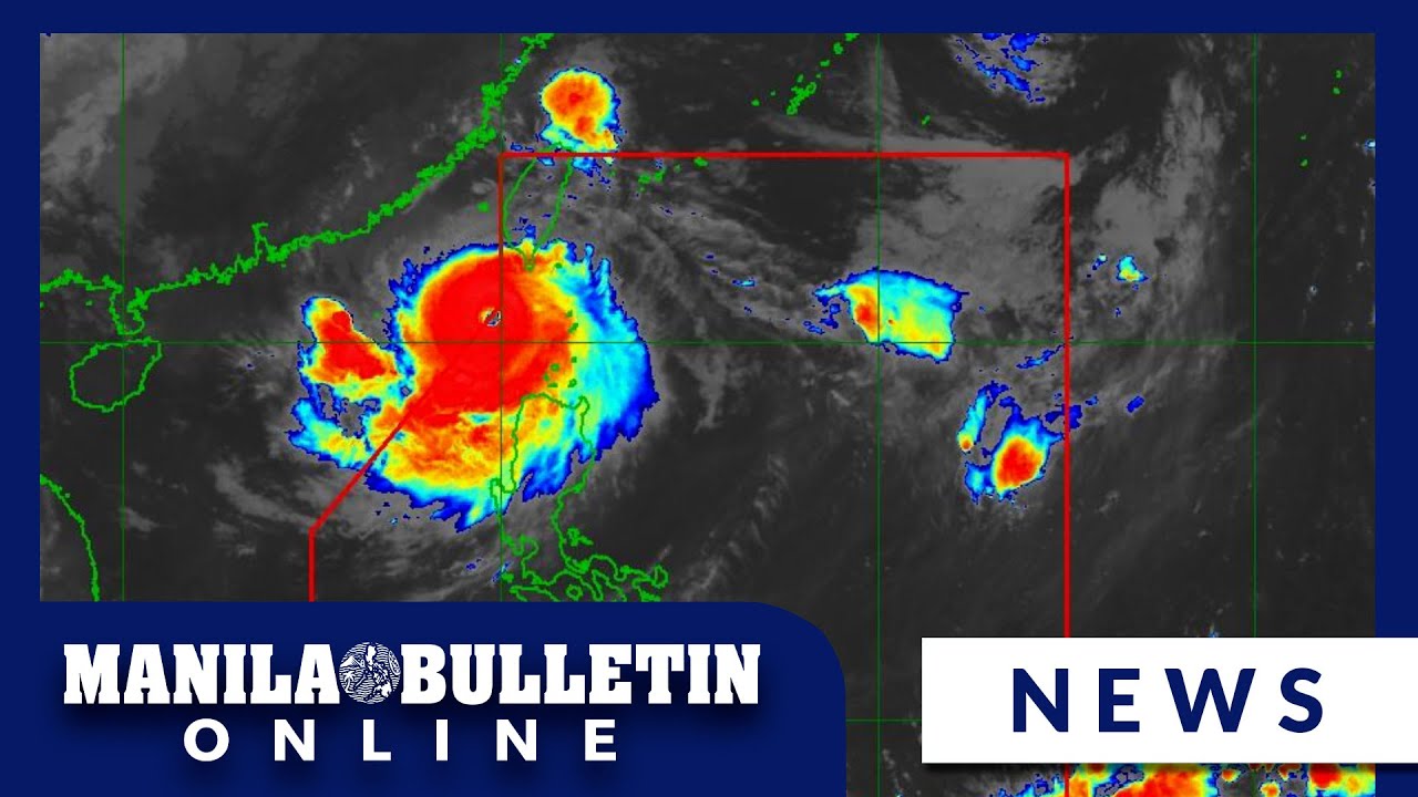
TLDRTropical Storm Ferd, known internationally as Bebinca, has entered the Philippine area of responsibility and is currently located 1,210 km east northeast of extreme Northern Luzon. It is expected to move west northwestward towards Japan, potentially intensifying into a typhoon. The storm's outer effects, combined with the Southwest Monsoon, will bring heavy to intense rainfall across Southern Luzon, including Metro Manila, and parts of Visayas and Mindanao. The weather system may also cause gusty conditions and rough seas in the southern seaboards. The Pag-asa Weather Forecasting Center advises areas to be prepared for heavy rainfall warnings and landslides, with 100 to 200 mm of rainfall anticipated over the next three days.
Takeaways
- 🌀 Tropical Storm Ferd (locally named Musika) has entered the Philippine Area of Responsibility.
- 📍 As of 4:00 AM, the storm is located 1,210 km East northeast of extreme Northern Luzon.
- 💨 The storm has a wind speed of 85 kmph with gusts reaching up to 105 km per hour.
- 🌍 The storm is moving West northwestward at a speed of 20 km per hour.
- 🌤️ The Southwest Monsoon is affecting most parts of the country, bringing scattered rainshowers and thunderstorms.
- 🌧️ Southern Luzon, including Metro Manila, Zambales, and Bataan, will experience heavy rainshowers with thunderstorms.
- 🌦️ MIMAROPA and the western section of Visayas will have occasional rainshowers.
- ☀️ Maximum temperatures are forecasted to reach 32°C in Tuguegarao, 23°C in Baguio City, and 30°C in Metro Manila.
- 🌧️ Heavy to intense rainfall is expected in MIMAROPA, Western Visayas, and Negros Occidental due to the Southwest Monsoon and Tropical Storm Ferd.
- 🌪️ The storm is expected to strengthen into a severe tropical storm or possibly a typhoon as it moves towards the East China Sea.
- 🚨 Heavy rainfall warnings or advisories may be issued by the Pag-asa Regional centers for areas significantly affected by the storm and monsoon rains.
Q & A
What is the international name of the tropical storm mentioned in the script?
-The international name of the tropical storm is Bebinka.
What was the latest location of the storm at 4:00 AM as per the script?
-The latest location of the storm at 4:00 AM was 1,210 km East northeast of the extreme Northern Luzon.
What is the current wind strength and gustiness of the storm?
-The storm has a near-center wind strength of about 85 kmph, with gustiness reaching up to 105 km per hour.
In which direction is the storm moving and at what speed?
-The storm is moving West northwestward at a speed of 20 km per hour.
What is the effect of the Southwest Monsoon on the weather in the Philippines as per the script?
-The Southwest Monsoon is causing widespread rain showers and thunderstorms across the country, with the storm enhancing its effects.
Which areas in Luzon are expected to experience heavy rain and thunderstorms?
-Southern Luzon, including Metro Manila, Zambales, and Bataan, are expected to experience heavy rain and thunderstorms.
What is the forecast for maximum temperatures in Metro Manila and Baguio City?
-The maximum temperature forecast for Metro Manila is 30°C, and for Baguio City, it is 23°C.
What are the expected weather conditions in the Visayas and Mindanao?
-Most of the Visayas and Mindanao are expected to experience a high chance of rain, while the Davao Region may have monsoon rains and occasional thunderstorms.
What is the forecast for the storm's intensity as it moves towards the East China Sea?
-The storm, named Bebinka, may strengthen into a severe tropical storm or even a typhoon category while in the East China Sea.
What areas can expect heavy to intense rainfall in the next three days due to the Southwest Monsoon?
-Areas such as MIMAROPA, Western Visayas, and Negros Occidental can expect heavy to intense rainfall in the next three days.
What is the expected rainfall amount in the affected areas?
-The expected rainfall amount in the affected areas is between 100 to 200 mm, indicating heavy to intense rainfall.
What precautions are advised for sea travel due to the ongoing Southwest Monsoon?
-Moderate to rough sea conditions are expected, so sea travel should be approached with caution, especially along the seaboards of Southern Luzon, Visayas, and Mindanao.
Outlines
🌀 Tropical Storm Ferd and Weather Updates
The Pag-asa Weather Forecasting Center provides an update on Tropical Storm Ferd, known internationally as Bebinka, which has entered the Philippine area of responsibility. As of 4:00 AM, the storm is located 1,210 km east northeast of extreme Northern Luzon with winds of 85 kmph, gusting up to 105 kmph. It is moving west northwestward at a speed of 20 km per hour. The storm's presence, along with the Southwest Monsoon, is expected to bring scattered rain showers and thunderstorms across the country, particularly in Southern Luzon, including Metro Manila, Zambales, and Bataan. Other areas like MIMAROPA and the western section of the Visayas may experience occasional rain. The weather is expected to be partly cloudy with a chance of scattered thunderstorms in Central and Eastern Visayas and most of Mindanao. The maximum temperature forecast for various regions is provided, with 32°C expected in the Ilocos region, 30°C in Metro Manila, and varying temperatures in other areas like Legaspi, Tagaytay, Palawan, and the Kalayaan Islands. The forecast also notes the potential for heavy to intense rainfall in the next three days due to the monsoon and the tropical storm's influence.
🌧️ Rainfall and Wind Warnings for the Philippines
The weather forecast details the expected rainfall and wind conditions across the Philippines due to the Southwest Monsoon and Tropical Storm Ferd. Areas such as Batangas, MIMAROPA, Bicol Region, the entire Visayas, and Northern Mindanao are expected to experience gusty winds and heavy rainfall. The forecast warns of significant amounts of rainfall, with 100 to 200 mm expected in the next three days, particularly in MIMAROPA, Western Visayas, and Negros Occidental. Other areas like Zambales, Bataan, Cavite, Laguna, Batangas, and Southern Quezon are also expected to have moderate to heavy rainfall. The forecast advises that the rain will gradually decrease in areas like Mindanao and the central and eastern sections of the Visayas starting tomorrow morning to Monday morning. However, heavy to intense rains are still expected in Occidental Mindoro, the northern part of Palawan, and Antique. The Pag-asa Weather Forecasting Center advises residents to be prepared and vigilant for possible floods and landslides due to the ongoing rains. Additionally, sea travel warnings are issued for Southern Luzon, Visayas, and Mindanao due to the expected rough sea conditions.
Mindmap
Keywords
💡Bagyong Ferd
💡Tropical Storm
💡Monsoon
💡Wind Speed
💡Rainfall
💡Weather Forecasting
💡Typhoon Category
💡Philippine Area of Responsibility
💡Heavy Rainfall Warnings
💡Sea Conditions
💡Climate Zones
Highlights
Tropical Storm Ferd (international name: Bebinka) has entered the Philippine area of responsibility.
Ferd is currently a tropical storm with sustained winds of 85 kmph and gusts up to 105 kmph.
The storm is moving west northwestward at a speed of 20 km per hour.
Southwestern Monsoon is affecting most parts of the country, bringing heavy rain and thunderstorms.
Areas in Southern Luzon, including Metro Manila, Zambales, and Bataan, will experience heavy rain and thunderstorms.
MIMAROPA and Occidental Mindoro may see occasional rain.
The rest of Central Luzon and Northern Luzon are expected to have fair weather.
Most of Visayas and Mindanao will have a high chance of rain.
The Davao Region may experience monsoon rains.
Maximum temperature in Metro Manila is forecasted to reach 30°C.
Baguio City may see cooler temperatures of 23°C.
Ferd is expected to strengthen into a severe tropical storm or possibly a typhoon as it moves towards Okinawa, Japan.
The storm will not have a direct impact on the Philippines but will cause gusty conditions in some areas.
Areas like Batangas, MIMAROPA, Bicol Region, and Northern Mindanao can expect gusty winds.
Heavy to intense rainfall is expected in MIMAROPA, Western Visayas, and Negros Occidental due to the Southwest Monsoon.
Moderate to heavy rains are forecasted for Southern Quezon, the whole of MIMAROPA, Negros Island region, and Western Visayas.
Rainfall is expected to decrease in areas of Mindanao and the central and eastern sections of Visayas.
Heavy to intense rains may continue in areas like Occidental Mindoro and the northern part of Palawan.
Moderate to heavy rains are expected in Camarines Sur, Catanduanes, Albay, Sorsogon, Masbate, Negros Occidental, and Western Visayas.
Sea conditions may be moderate to rough in the seaboards of Southern Luzon, Visayas, and Mindanao due to the Southwest Monsoon.
Transcripts
[Musika]
Magandang umaga mula sa pag-asa weather
forecasting Center ito na ating update
sa binabantayan nating si Bagyong ferd
so kaninang madaling araw ay lumabas rin
agad ang ating Philippine area of
responsibility itong si Bagyong ferd So
may international name ito na bebinca so
sa pa rin itong Tropical storm at yung
latest location natin kaninang 4:00 ng
umaga ay sa layong
1,210 km East northeast ng extreme
Northern Luzon Ah ito ay may taglay na
lakas ng hangin na malapit sa gitna na
umaabot sa 85 kmph pag bugso na umaabot
sa 105 km per kasalukuyan itong
gumagalaw West northwestward sa bilis na
20 km per So kahit na nasa labas na ito
ng ating par ay makikita natin dito sa
ating latest satellite images Itong mga
makakapal na kaulapan na umiiral sa
malaking bahagi ng ating bansa ay ang
patuloy na epekto ng Southwest Monson o
habagat na hinahatak ng nasabing bagyo
at Ah ito nga ang ating magiging lagay
ng panahon ngayong araw sa ating bansa
so dito sa area ng Luzon dahil sa epekto
ng habagat malaking bahagi pa rin ng
Southern Luzon including Metro Manila
pati na rin itong areas ng Zambales at
Bataan makakaranas ng mataas sa tansa ng
mga kalat-kalat na pag-ulan na
sinasamahan ng pagkulog at pagkidlat
pinak maapektuhan ng Monson rins o yung
mga direktang pag-ulan na dala ng
habagat itong areas ng MIMAROPA at
occasional range naman dito sa area ng
kabikulan Ah mas maaliwalas sa panahon
naman ating inaasahan sa rest of Central
Luzon pati na rin sa buong hilagang
Luzon ngayon pa naman posible pa rin
yung tansa ng mga biglaan at
panandaliang buhos ng ulan nadulot nga
ng trf o Extension ng Tropical storm sa
labas ng ating Philippine Area of
responsibility maximum temperature
forecast para sa lawag ngayong araw
posibleng umabot ng 32° cels 32° naman
dito sa area ng tagarao at 23° Cel sa
Baguio City maximum temperature forecast
ngayong araw sa Metro Manila posibleng
umabot ng 30° Cel at 29° naman dito sa
areas ng Legaspi at
Tagaytay sa bahagi naman ng Palawan
Visayas at sa Mindanao ah malaking
bahagi rin ng Visayas Actually buong
Visayas pati na rin sa area ng Palawan
at most of Mindanao makakaranas ng
mataas na tiyansa ng pag-ulan samantala
bahagyang maulap hanggang sa maulap na
papawiin na sinasamahan ng mga isolated
rain showers or thunderstorms sa ating
inaasahan sa bahagi ng Davao Region so
Monson rains rin na ating inaasahan dito
sa area ng Palawan at dito sa Western
section ng Visayas at ah samantala
cloudy skies at mataas sa tiyansa ng mga
kalat-kalat na thunderstorms sa ating
inaasahan sa Central at Eastern Visayas
p na rin sa most of Mindanao maximum
temperature forecast para sa kalayaan
Islands ngayong araw posibleng umabot ng
31° Cel 30° naman dito sa area ng Puerto
Prinsesa 29° Cel sa ilo-ilo at 31° Cel
sa areas ng Cebu at Tacloban maximum
temperature forecast para sa Cagayan de
Oro ngayong araw posibleng umabot ng 30°
Cel 32° naman sa area ng Davao at 31°
Cel sa bahagi ng Zamboanga at ito nga
ung ating latest truck and intensity
forecast para kay Tropical storm ferd so
internationally internationally name
niya bibinka at nasa labas na nga ito ng
ating Philippine area of responsibility
ah lumabas ito kaninang madaling araw so
magpapatuloy yung generally Northwest w
na paggalaw ng nasabing baguyo patungo
sa Okinawa Japan and magiging generally
West northwestward Iyung galaw nito
habang nandito ito sa area ng east china
sea so within this forecast period
posibleng lumakas muli into a severe
Tropical storm category itong Ah si
bibinka Habang nasa labas ito ng ating
par at possibly into a typhone category
habang sa east china se so mananatiling
Malayo pa rin itong si ferdy sa ating
kalupaan at Ah wala na itong magiging
dirang epekto sa anumang bahagi ng ating
bansa ah gayon pa man dahil sa epekto ng
habagat na hinahatak pa rin ng nasabing
bagyo sa labas ng ating par ah
makakaranas pa rin tayo ng mga
pabugso-bugsong hangin sa ilang bahagi
ng ang ating bansa so Starting Today
hanggang tomorrow asahan natin itong mga
pabugso-bugsong hangin sa mga areas ng
Batangas MIMAROPA Bicol Region buong
Visayas sa Caraga Region Northern
Mindanao Zamboanga Peninsula barm at
Davao Region mababawasan yung mga
pabugso yung mga pagbugso ng hangin sa
areas ng Batangas at barm pagsapit ng
Lunes in ter in terms naman of rainfall
o yung mga malalakas sa pag-ulan na dala
ng habagat significant amount amounts of
rainfall pa rin na ating inaasahan in
the next 3 days nadala ng Southwest
munson na hinahatak nga ng naturang
bagyo so 100 to 200 mm of rainfall ito
Iyung heavy to intense rainfall ang
ating inaasahan dito sa areas ng
MIMAROPA Western Visayas at Negros
Occidental katamtaman h sa lalakas sa
pag-ulan naman ang ating mararanasan sa
Zambales Bataan Cavite Laguna Batangas
Southern portion ng Quezon dito sa
kabikulan nalalabing bahagi ng Visayas
Misamis Occidental Zamboanga del Norte
Lanao del Norte Lanao del Sur
Maguindanao del Norte Maguindanao del
Sur Sultan kodarat Sarangani Basilan
Sulu at sa tawitawi
unti-unti na mababawasan yung mga
pag-ulan na dala ng habagat especially
dito sa areas ng Mindanao at sa central
and eastern sections ng Visayas starting
tomorrow morning to Monday morning gayon
pa man posible pa rin yung mga heavy to
intense rainfall magpapatuloy dito sa
areas na Occidental Mindoro northern
portion ng Palawan Aklan at Antique
samantala moderate to heavy rins naman
ating inaasahan sa Southern portion ng
Quezon buong kabikulan nalalabing bahagi
ng MIMAROPA Negros Island region at sa
nalalabing bahagi ng Western
Visayas mababawasan pa yung mga pag-ulan
na dala ng habagat pagsapit ng Monday
morning to Tuesday morning especially
dito sa areas ng Quezon at sa Dito nga
sa area ng Negros Oriental gayon pa man
magpapatuloy Iyung heavy to intense
rains dito sa area ng Occidental Mindoro
at sa northern portion ng Palawan
moderate to heavy rains magpapatuloy
dito sa nalabing bahagi ng may marop
Camarines Sur Catanduanes Albay Sorsogon
Masbate Negros Occidental at Western
Visayas kaya sa mga nabanggit na lugar
for the next 3 days posible pa rin
tayong magtaas diyan yung ating mga
kasamahan sa pag-asa Regional centers
posible pa ring mag-issue ng heavy
rainfall warnings or rainfall
advisories kaya sa mga nabanggit na
lugar patuloy po tayong maging handa at
alerto sa mga banta ng pagbaha at
pagguho ng lupa dahil inaasahan natin na
tuloy-tuloy pa rin yung mga pag-ulan na
ating mararanasan in the next 3 days na
dunot niya ng habagat especially sa
areas ng Southern Luzon at ng
Visayas sa kalagayan naman nating
karagatan as of 5 a.day wala tayong
nakataas na Gale warnings anoang Baybay
na ating kapuluan gayun pa man iba ung
pag-iingat pa rin sa ating mga kababayan
na maglalayag especially sa seaboards ng
Southern Luzon Visayas at Mindanao dahil
sa patuloy na epekto ng habagat posible
pa rin tayong makaranas diyan ng
moderate to rough sea conditions ito
yung katamtaman hanggang sa maalong
karagatan at yan lamang po ang latest
mula dito sa pag-asa weather forecasting
Center Magandang umaga sa ating lahat
Ako po si Dan villamil gulat
Ver Más Videos Relacionados
Storm trough, ‘habagat’ to bring rains across parts of the Philippines
PAGASA: ‘Bebinca’-enhanced ‘habagat’ rains to last 3–4 days
PAGASA warns of heavy rains due to ‘habagat’
Bagyong Gener at Bagyong tatawaging "Helen," posibleng magsabay sa loob ng PAR ngayong... | 24 Oras
Public Weather Forecast issued at 4AM | September 15, 2024 - Sunday
Weather update as of 11:05 a.m. (September 19, 2024) | Balitanghali
5.0 / 5 (0 votes)