Penginderaan Jauh | Geografi | Alternatifa
Summary
TLDRThe video explains the role of technological advances in obtaining geographical data through remote sensing and geographic information systems (GIS). Remote sensing allows us to collect data from satellites, drones, and other vehicles without direct contact with the area. The data gathered is processed using GIS software to create thematic maps, tables, and diagrams. The benefits of remote sensing include analyzing large areas, fast digital processing, and free access to data from sources like the USGS. However, challenges include high equipment costs and the limitations of what can be detected remotely.
Takeaways
- 😀 Technological advances have made it easier to access information on political economy, the lives of artists, and geographic data like maps and traffic conditions.
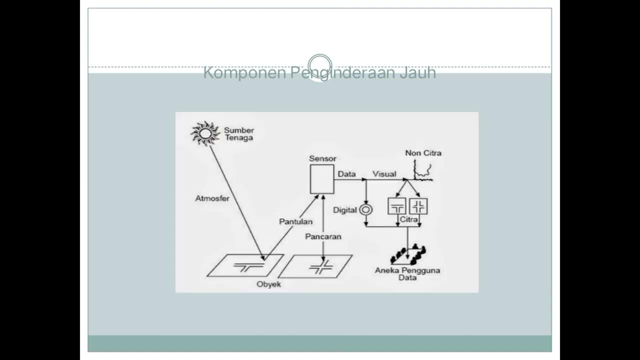
- 🌍 Remote sensing is a technique used to obtain information about an area or object without physical contact, utilizing technologies like satellites, drones, and aircraft.
- ☀️ The Sun plays a critical role in remote sensing by providing energy that affects temperature, evaporation, humidity, and the hydrological cycle on Earth's surface.
- 🚁 Remote sensing vehicles such as drones, satellites, and aircraft capture images and data, which are processed into useful products like thematic maps and diagrams.
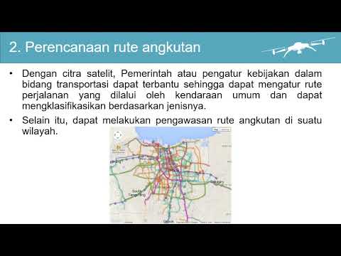
- 📷 Remote sensing enables us to analyze large areas without physically visiting them, which is particularly useful during events like floods, as seen with the 2020 Jakarta flood data.
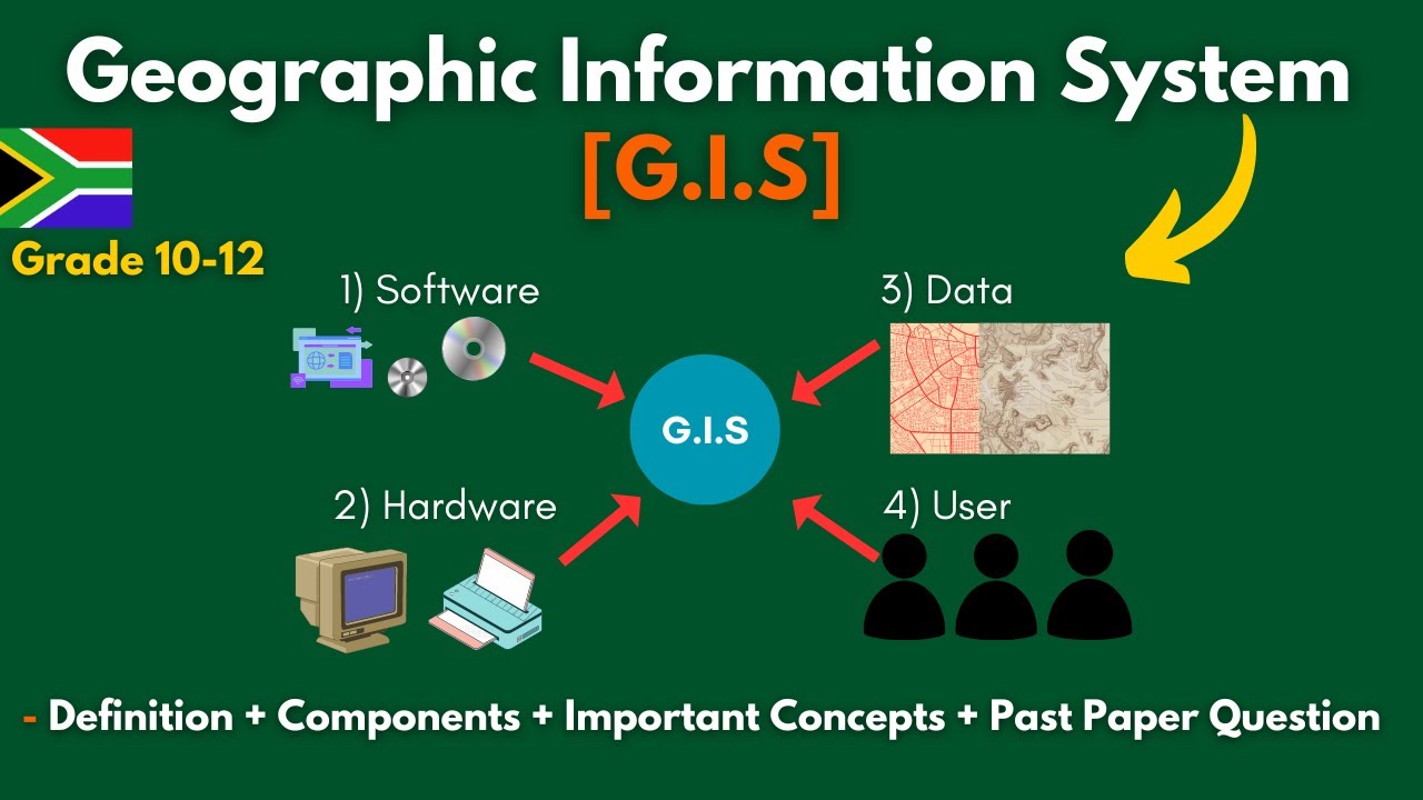
- 🖥️ Geographic Information Systems (GIS) software like ArcGIS and Erdas is used to process remote sensing data, enabling the creation of maps, tables, and other analytical products.
- 🌐 Remote sensing and GIS are closely related, with remote sensing focusing on data collection and GIS specializing in processing and manipulating that data.
- 🌎 One advantage of remote sensing is its ability to cover large geographic areas, especially when using satellites, and provide digital analysis quickly and efficiently.
- 💡 Remote sensing helps in urban planning and spatial analysis, offering 3D models of both natural and urban environments.
- 💰 The disadvantages of remote sensing include the high cost of equipment like drones and satellites, the limited availability of high-resolution data for free, and the inability of some sensors to measure specific soil or mineral conditions.
Q & A
What is remote sensing and how does it work?
-Remote sensing is a technique used to gather information about an area or object without physical contact. It involves using vehicles like satellites, drones, or airplanes to capture data through sensors, which is then processed to provide valuable information about the Earth's surface and phenomena.
What role does sunlight play in remote sensing?
-Sunlight is the primary energy source in remote sensing. It illuminates the Earth's surface, causing variations in temperature and humidity. Sunlight also drives the hydrological cycle, influencing weather patterns and rainfall distribution, all of which are crucial for gathering accurate data in remote sensing.
What are some examples of vehicles used in remote sensing?
-Examples of vehicles used in remote sensing include satellites, hot air balloons, airplanes, and drones. These vehicles capture images and data from the Earth's surface, which is then used for analysis and processing.
How is data from remote sensing processed and presented?
-Once remote sensing data is collected, it is processed using GIS (Geographic Information System) software such as ArcGIS and ERDAS. The processed data can be presented as thematic maps, tables, or diagrams, which provide insights into various geographical conditions and phenomena.
Can remote sensing be used to monitor natural disasters, like floods?
-Yes, remote sensing is useful for monitoring natural disasters like floods. For example, during the 2020 Jakarta floods, drones were used to capture aerial images, helping to identify areas affected by floods without the need for physical presence on-site.
What are the advantages of using remote sensing for data collection?
-Some advantages of remote sensing include its ability to cover large areas, especially when using satellites. The data can be processed digitally and quickly with GIS software, and it can describe three-dimensional conditions, such as mountains or urban landscapes. Additionally, some remote sensing data is available for free from online sources like the USGS.
What are the disadvantages of remote sensing?
-The main disadvantages of remote sensing include the high cost of equipment like satellites and drones, the limited availability of high-resolution data for free, and the inability to gather certain types of information, such as soil pH or mineral content, which requires direct observation.
What is the difference between remote sensing and GIS?
-Remote sensing is the process of collecting data from a distance, using various vehicles and sensors. GIS (Geographic Information Systems), on the other hand, is the software used to process, manipulate, and analyze the collected data to produce maps, tables, and other useful products.
Where can people access free remote sensing data?
-Free remote sensing data can be accessed through various online platforms, such as the Geospatial Information Agency (BIG) in Indonesia and the United States Geological Survey (USGS) website. These platforms provide data on geological, hydrological, meteorological, and topographical conditions.
Why can't all data be collected through remote sensing?
-Not all data can be collected through remote sensing because certain information, such as soil pH, land fertility, or mineral types, requires direct observation or specialized instruments. Remote sensing is limited to capturing surface-level data like temperature, moisture, and elevation.
Outlines

Dieser Bereich ist nur für Premium-Benutzer verfügbar. Bitte führen Sie ein Upgrade durch, um auf diesen Abschnitt zuzugreifen.
Upgrade durchführenMindmap

Dieser Bereich ist nur für Premium-Benutzer verfügbar. Bitte führen Sie ein Upgrade durch, um auf diesen Abschnitt zuzugreifen.
Upgrade durchführenKeywords

Dieser Bereich ist nur für Premium-Benutzer verfügbar. Bitte führen Sie ein Upgrade durch, um auf diesen Abschnitt zuzugreifen.
Upgrade durchführenHighlights

Dieser Bereich ist nur für Premium-Benutzer verfügbar. Bitte führen Sie ein Upgrade durch, um auf diesen Abschnitt zuzugreifen.
Upgrade durchführenTranscripts

Dieser Bereich ist nur für Premium-Benutzer verfügbar. Bitte führen Sie ein Upgrade durch, um auf diesen Abschnitt zuzugreifen.
Upgrade durchführenWeitere ähnliche Videos ansehen

What is Remote Sensing and GIS?
Popy X 1 Dasar Pemetaan Indera SIG Geo X Regulasi Diri

Pengetahuan Peta, Pengindraan Jauh, dan Sistem Informasi Geografi (SIG) X SMA/MA

[สังคม] เครื่องมือทางภูมิศาสตร์ แผนที่ ดาวเทียม GPS
G.I.S (Geographic Information Systems)- Concepts, Components, Advantages + Past Paper | Grade 10-12.
Pengolahan Citra Penginderaan Jauh untuk jaringan transportasi
5.0 / 5 (0 votes)
