March 11, 2011 Japan Earthquake—10th Anniversary—Lessons Learned (educational)

IRIS Earthquake Science
7 Mar 202110:31

Summary

TLDRThe video script delves into the 2011 Tohoku-oki earthquake, Japan's largest in history, detailing its catastrophic impact and the scientific insights gained. It highlights the importance of tsunami geology, earthquake early warning systems, and the integration of GPS with seismometers for improved accuracy in warnings. The script also underscores the significance of public education in disaster preparedness, emphasizing the 'Drop, Cover, and Hold On' protocol during earthquakes and the natural tsunami warning they provide.

Takeaways

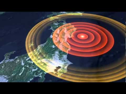
  • 🏔 Honshu is the largest of Japan's three major islands and is located on the Pacific Ring of Fire, making it prone to significant seismic activity.
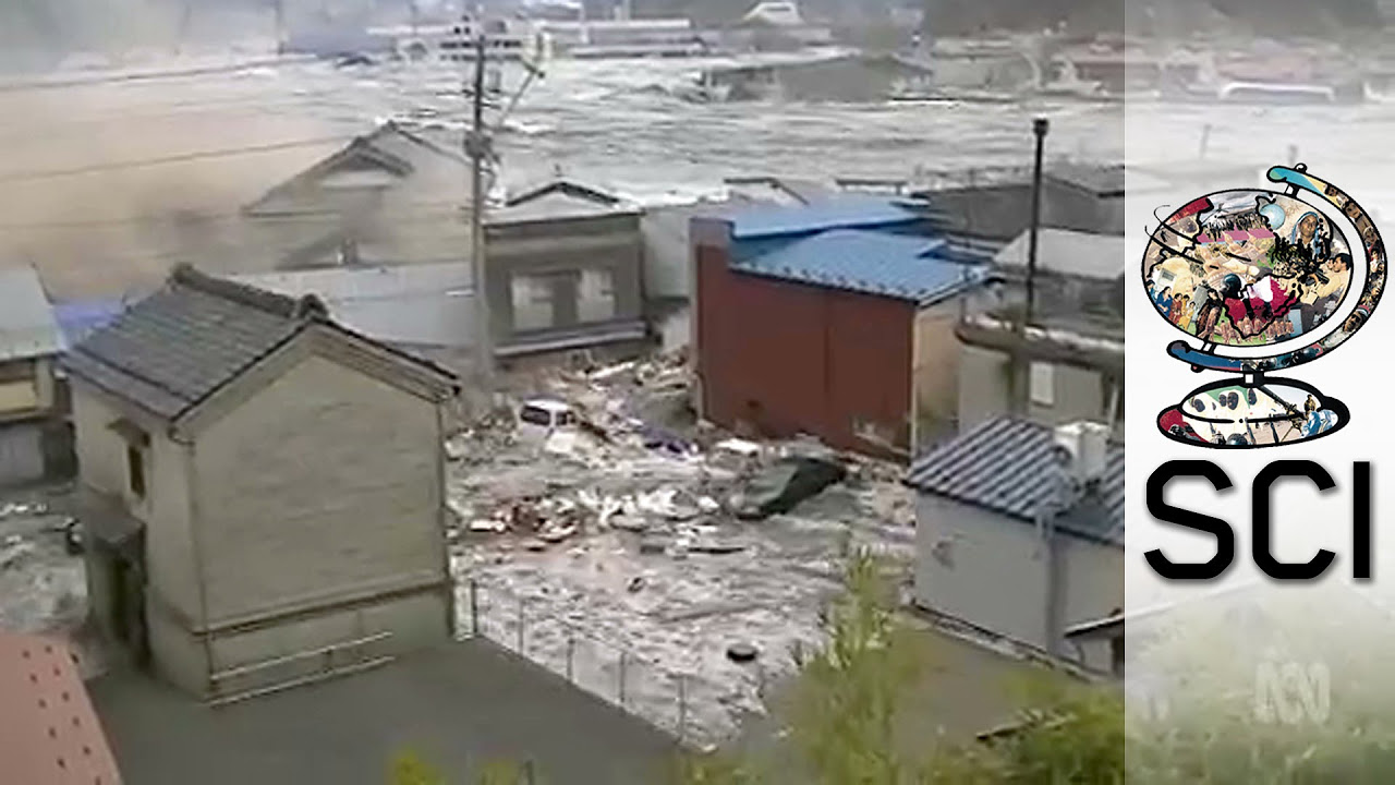
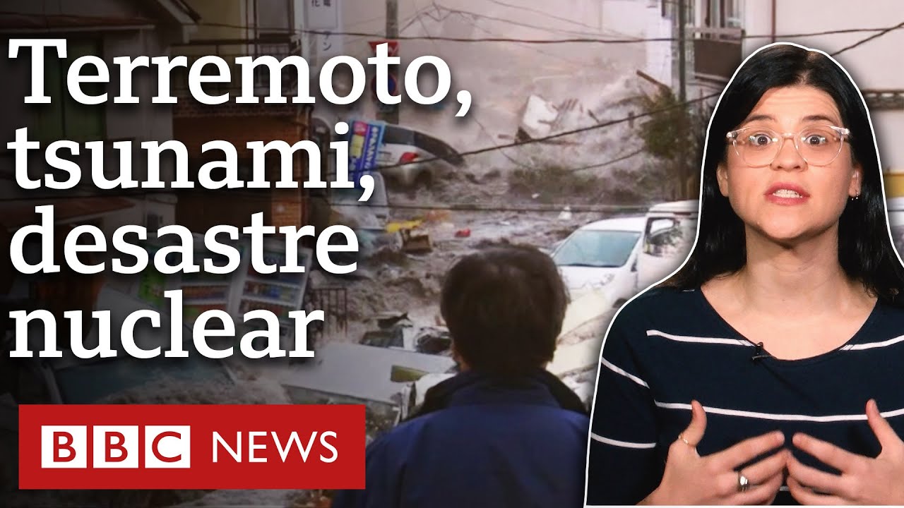
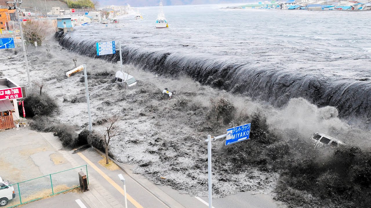
  • 🌊 The Tohoku region of northern Honshu experienced a devastating M9 earthquake on March 11, 2011, which resulted in a massive tsunami and nearly 20,000 lives lost.
  • 💡 Tsunami geology can extend the earthquake record by centuries or millennia, providing insights into past seismic events.
  • ⚠️ Earthquake Early Warning systems can mitigate damage and save lives but have limitations, as seen in the 2011 Tohoku earthquake.
  • 📍 The integration of Global Positioning System (GPS) observations with seismometer data improves the accuracy of earthquake early warning systems and is crucial for tsunami warnings.
  • 🔍 Historical and geological evidence suggests that the subduction plate boundary could store elastic energy over 1000-year intervals before releasing it in a large earthquake.
  • 🌋 The 2011 Tohoku-oki earthquake revealed that the megathrust plate boundary could produce earthquakes with magnitudes up to 9, much larger than previously thought.
  • 🔬 High-precision GPS monitoring is essential for understanding the mechanics of plate boundaries and the potential for large earthquakes.
  • 🏞️ The uplift and subsidence of the seafloor due to the earthquake's fault slip generated the tsunami that caused widespread damage and loss of life.
  • 🏗️ Japan's stringent building codes and quality construction practices, along with its earthquake early warning system, saved many lives despite the earthquake's severity.
  • 🚀 Advances in GPS and seismic network integration, such as Japan's GEONET, have improved the speed and accuracy of earthquake and tsunami warnings.

Q & A

  • What is the largest island in Japan?

    -Honshu is the largest of the three major Japanese islands.

  • Which region of Honshu has three prefectures facing the Pacific Coast and the Japan Trench?

    -The Tohoku region of northern Honshu has three prefectures on the Pacific Coast directly facing the Japan Trench.

  • What is the rate at which the Pacific Plate descends into the Japan Trench beneath the Okhotsk Plate?

    -The Pacific Plate descends into the Japan Trench and beneath the Okhotsk Plate at a rate of 8.3 cm/yr.

  • When did the M9 Tohoku-oki earthquake occur?

    -The M9 Tohoku-oki earthquake occurred just after 2:46 PM local time on March 11, 2011.

  • What were the consequences of the 2011 Tohoku-oki earthquake and tsunami?

    -The 2011 Tohoku-oki earthquake and resulting tsunami took almost 20,000 lives and caused approximately $200 billion in damage.

  • How can tsunami geology contribute to understanding earthquakes?

    -Tsunami geology can extend the earthquake record by centuries or millennia, providing a longer-term perspective on seismic activity.

  • What limitations were revealed by the 2011 earthquake in the Earthquake Early Warning system that uses only seismometers?

    -The 2011 earthquake revealed limitations of a system using only seismometers, such as the inability to rapidly determine fault slip or final magnitude, which is crucial for accurate tsunami warnings.

  • How does the addition of GPS observations improve earthquake early warning systems?

    -Adding Global Positioning System observations of earthquake ground motion improves the accuracy of earthquake early warning and is essential to tsunami warnings by providing more precise data on fault slip and ground movement.

  • What is the historical significance of the 869 A.D. earthquake and tsunami in the context of the Tohoku-oki earthquake?

    -The 869 A.D. earthquake and tsunami are significant because they indicate that the subduction plate boundary could store elastic energy over 1000-year intervals and then release it in a megathrust earthquake of magnitude 8.5 or even up to 9.

  • How did the high-precision GPS monitoring provide insights into the mechanics of the plate boundary before the Tohoku-oki earthquake?

    -High-precision GPS monitoring showed that stations across northern Honshu were being pushed westward at up to 3 cm/yr, indicating that the megathrust has high friction and could store elastic energy over many centuries.

  • What improvements have been made to earthquake and tsunami warning systems based on the lessons learned from the 2011 Tohoku-oki earthquake?

    -Improvements include the installation of GPS networks, advances in precision and speed of receivers, integration of GPS and seismic networks, and the installation of the S-net cabled system of ocean bottom seismometers and pressure gauges for earlier and more accurate warnings.

Outlines

00:00

🌏 The Tohoku Earthquake and Tsunami: A Lesson in Geology and Preparedness

This paragraph discusses the devastating impact of the M9 Tohoku-oki earthquake that struck Japan on March 11, 2011, resulting in nearly 20,000 casualties and $200 billion in damages. It highlights the importance of tsunami geology in extending the earthquake record, the limitations of earthquake early warning systems, and the necessity of integrating Global Positioning System (GPS) observations for improved accuracy in earthquake and tsunami warnings. The paragraph also underscores the significance of public education in earthquake and tsunami preparedness, emphasizing the simple yet effective 'Drop, Cover, and Hold On' protocol, and the importance of moving to higher ground in the event of a coastal earthquake. The historical context of the earthquake is provided, including the discovery of a sand layer indicating a massive tsunami in 869 A.D., and the subsequent research that suggested the potential for a megathrust earthquake of magnitude 8.5 or greater. The paragraph concludes with an explanation of how high-precision GPS monitoring can offer insights into plate boundary mechanics and the storage of elastic energy over centuries, which was released during the 2011 earthquake.

05:05

📡 Advancements in Earthquake and Tsunami Warning Systems

The second paragraph delves into the specifics of the Tohoku-oki earthquake's impact, noting the areas most affected and the fatalities that occurred. It describes the fault rupture's spread and the minimal number of deaths outside the tsunami zone, attributing this to Japan's advanced earthquake engineering and building practices. The paragraph also examines the limitations of Japan's earthquake early warning system during the Tohoku-oki earthquake, which was unable to accurately predict the magnitude and resulting tsunami height due to its reliance on seismometer data alone. The narrative then pivots to discuss improvements in warning systems, including the integration of GPS networks with seismic networks, exemplified by GEONET in Japan. The power of combining GPS and seismometer observations is illustrated through the case study of the 2011 earthquake, where GPS stations recorded significant movements. The paragraph concludes with the introduction of the S-net cabled system, which offers earlier earthquake warnings and more accurate tsunami forecasts by utilizing instruments on the ocean floor above the plate boundary megathrust.

Mindmap

Keywords

💡Honshu

Honshu is the largest of the three major Japanese islands. It is significant in the video script as the location of the Tohoku region, which was directly affected by the 2011 Tohoku-oki earthquake. The island's geography and its position relative to the Japan Trench are crucial to understanding the tectonic activity that led to the disaster.

💡Subduction Zone

A subduction zone is a geological boundary where one tectonic plate moves under another and sinks into the mantle. In the context of the video, the Pacific Plate descends into the Japan Trench beneath the Okhotsk Plate, creating a high-risk area for earthquakes and tsunamis, as seen with the M9 Tohoku-oki earthquake.

💡Tohoku-oki Earthquake

The Tohoku-oki Earthquake refers to the magnitude 9.0 earthquake that occurred on March 11, 2011. It is a central event in the video, illustrating the devastating impact of such natural disasters, including the loss of lives and economic damage. The term 'oki' is Japanese for 'offshore,' emphasizing the undersea origin of the quake.

💡Tsunami

A tsunami is a series of ocean waves caused by a large-scale, sudden displacement of water, typically following an undersea earthquake. The video script discusses the tsunami generated by the Tohoku-oki earthquake, highlighting its role in the extensive damage and fatalities along the coast of Tohoku.

💡Earthquake Early Warning (EEW)

Earthquake Early Warning systems are designed to provide rapid alerts following the detection of an earthquake's initial P-waves, before the more destructive S-waves arrive. The video explains the limitations of the 2011 EEW system in Japan and how it has been improved by integrating GPS data to provide more accurate and timely tsunami warnings.

💡Global Positioning System (GPS)

The Global Positioning System is a satellite-based navigation system that provides location and time information. In the video, GPS observations are discussed as a critical tool for monitoring ground motion during earthquakes, enhancing the accuracy of early warning systems and contributing to better tsunami predictions.

💡Megathrust Earthquake

A megathrust earthquake occurs at subduction zones when the plates are locked together and then suddenly slip. The video script describes the 2011 Tohoku-oki earthquake as a megathrust event, noting the immense energy release and the significant fault slip that caused the devastating tsunami.

💡Geoscientists

Geoscientists are professionals who study the Earth's structure, processes, and other physical aspects. The script mentions geoscientists discovering a sand layer indicative of a historical tsunami, demonstrating their role in understanding past events and informing disaster preparedness.

💡Plate Tectonics

Plate tectonics is the theory that describes the movement of Earth's lithosphere, which is divided into several plates. The video uses plate tectonics to explain the forces at work in the Tohoku region, particularly the interaction between the Pacific and Okhotsk plates that led to the 2011 earthquake.

💡S-net

S-net refers to a system of ocean bottom seismometers and pressure gauges that monitor seismic activity and tsunami formation. The video script highlights S-net as an advancement in tsunami monitoring, capable of providing earlier warnings and more precise tsunami forecasts.

💡GeoNET

GeoNET, or the Geographical Survey Institute's Nationwide GPS Array, is a network of GPS stations in Japan. The video script presents GeoNET as an example of how integrating GPS with seismic networks can improve earthquake and tsunami warning systems, providing more accurate and rapid responses.

Highlights

Honshu is the largest of the three major Japanese islands with a subduction zone boundary.

The Tohoku region of northern Honshu faces the Japan Trench with three prefectures on the Pacific Coast.

The Pacific Plate descends into the Japan Trench at a rate of 8.3 cm/yr.

The M9 Tohoku-oki earthquake on March 11, 2011, resulted in nearly 20,000 lives lost and $200 billion in damage.

Tsunami geology can extend the earthquake record by centuries or millennia.

Earthquake Early Warning systems can mitigate damage and save lives but have limitations.

GPS observations improve the accuracy of earthquake early warning and are essential for tsunami warnings.

Lessons from the 2011 Tohoku-oki earthquake are being applied to global earthquake and tsunami warning systems.

Public education is crucial for earthquake and tsunami preparedness.

Basic safety measures during an earthquake include 'Drop, Cover, and Hold On'.

An earthquake near the ocean serves as a natural tsunami warning, prompting evacuation to higher ground.

Historical earthquake data suggests that magnitudes might not exceed 8.2 on the megathrust plate boundary.

Geoscientists discovered evidence of an 869 A.D. earthquake and tsunami with a magnitude of at least 8.4.

High-precision GPS monitoring provides insight into plate boundary mechanics and energy storage.

The 2011 Tohoku-oki earthquake demonstrated the potential for energy storage over centuries in a subduction zone.

The earthquake's rupture started 24 km beneath the seafloor and propagated in both directions.

Fault slip of over 60 meters at the Japan Trench is the largest documented in modern history.

The tsunami from the earthquake reached inundation heights of 20 meters on the Sendai Plain.

Japan's earthquake engineering, building codes, and construction practices saved thousands of lives.

Japan's early warning system issued warnings 14 seconds before strong shaking in Sendai.

The early warning system's limitations were exposed by the inability to rapidly determine fault slip or final magnitude.

Integration of GPS and seismic networks, like GEONET in Japan, improves earthquake and tsunami warnings.

The S-net system of ocean bottom seismometers and pressure gauges enhances subduction zone monitoring.

S-net can provide earlier earthquake warnings and more accurate tsunami forecasts for coastal communities.

Transcripts

play00:05

Honshu is the largest of the three major  Japanese islands. The Tohoku region of  

play00:09

northern Honshu has three prefectures on  the Pacific Coast directly facing the Japan  

play00:14

Trench. At this subduction zone boundary, the  Pacific Plate descends into the Japan Trench  

play00:19

and beneath the Okhotsk Plate at 8.3 cm/yr. The M9 Tohoku-oki earthquake occurred just  

play00:34

after 2:46 PM local time on March 11, 2011. This  great earthquake and resulting tsunami took almost  

play00:46

20,000 lives and caused approximately  $200 billion damage. Scientific lessons  

play00:53

learned and described here include: 1. Tsunami geology can extend the  

play00:58

earthquake record by centuries or millenia. 2. Earthquake Early Warning can mitigate damage  

play01:00

and save lives, but the 2011earthquake revealed  limitations of a system using only seismometers. 

play01:07

3. Adding Global Positioning System  observations of earthquake ground motion  

play01:12

improves accuracy of earthquake early  warning, and is essential to tsunami warnings.

play01:21

These seismology and geodesy lessons from  the 2011 Tohoku-oki earthquake are being  

play01:26

applied to earthquake and tsunami warning  systems worldwide. However, these technical  

play01:31

advances are necessary but not sufficient to  advance earthquake and tsunami preparedness.  

play01:37

Public education is essential and often the  most basic lessons are the most empowering.  

play01:43

During an earthquake, Drop, Cover, and  Hold On. If you are near the ocean,  

play01:48

the earthquake is your natural tsunami warning.  Move quickly away from the shore to high ground 

play01:56

Now let’s dig into the plate  tectonics and earthquake history. 

play02:00

A cross section through the March  11 epicenter shows the Pacific Plate  

play02:04

subducting beneath the Okhotsk Plate. Before  2011, what observations did we have about  

play02:16

earthquakes on this megathrust plate boundary? For each earthquake of magnitude 7.4 and larger  

play02:22

earthquakes from 1896 to 2010, the year and  rupture area of the plate boundary that moved  

play02:28

during the earthquake are shown along with the  earthquake magnitude. This history suggests  

play02:34

that earthquake magnitudes might not exceed  8.2. But research in the decade before the  

play02:39

Tohoku-oki earthquake led some seismologists  to conclude that an earlier earthquake  

play02:44

with magnitude of at least 8.4 had caused a  massive tsunami that inundated the Sendai plains. 

play02:51

Geoscientists found a sand layer they interpreted  as having been deposited by that tsunami.  

play02:57

Historical documents revealed that this earthquake  and tsunami occurred in 869 A.D. . This geologic  

play03:04

evidence suggested the subduction plate  boundary could store elastic energy over  

play03:08

1000-year intervals then release that energy  in a megathrust earthquake of magnitude 8.5  

play03:15

or perhaps even up to magnitude 9, 25 times  more energy than any earthquake since 1896. 

play03:24

How could they test their hypothesis that  energy was being stored? Compression of the  

play03:58

overriding plate stores elastic energy similar  to a spring when the coils are pushed together. 

play04:05

High-precision GPS monitoring can provide  insight into the mechanics of a plate boundary. 

play04:09

Seismologists determined that motion between the  Pacific and Okhotsk plates during earthquakes of  

play04:10

the past few centuries was  much less than the relative  

play04:13

plate motion. And across northern Honshu,  GPS observations from 1990 to 2010 showed  

play04:13

stations being pushed westward at up to 3 cm/yr,  indicating that the megathrust has high friction.  

play04:15

So, this subduction zone could store  elastic energy over many centuries  

play04:20

then rebound during a massive  earthquake. As it did on March 11, 2011. 

play04:26

Rupture started 24 km beneath the seafloor  at the hypocenter, then propagated both up  

play04:32

to the east and down to the west. Fault  slip of 40 meters at the hypocenter and  

play04:45

over 60 meters at the Japan Trench are the largest  documented for any earthquake in modern history.  

play04:52

The 40-km-wide seafloor slope west of the trench  uplifted 10 meters while the seafloor near the  

play04:58

coast dropped 2 meters. These offsets of the  ocean floor produced the tsunami that rushed  

play05:04

onshore starting 30 minutes after the earthquake.  Inundation height reached 20 meters on the Sendai  

play05:10

Plain, the most populous area in Tohoku.  Tsunami runup in some locations reached 40  

play05:16

meters! Fatalities plus missing, concentrated  in Iwate, Miyagi, and Fukushima prefectures,  

play05:23

totaled almost 20,000. In map view,  

play05:27

fault rupture spread from the epicenter to  cover an area 500 km long by 200 km wide  

play05:33

in just over 2 minutes. Fault slip was greatest  between the epicenter and the Japan Trench. 

play05:41

Despite minutes of strong to severe ground  shaking, fewer than 50 fatalities occurred outside  

play05:47

of the tsunami zone. Centuries of experience  with earthquakes, world leadership in earthquake  

play05:53

engineering, stringent building codes, and quality  construction practices saved thousands of lives.  

play05:59

Japan’s earthquake early warning system also  decreased impacts of earthquake ground shaking. 

play06:04

the Earthquake warning system, in place  prior to the Tohoku-oki earthquake,  

play06:09

used a dense network of broadband seismometers  that detects P waves from an earthquake,  

play06:13

locates the epicenter, estimates magnitude, then  provides warnings before potentially damaging S  

play06:19

waves and surface waves arrive. This works  reasonably well for magnitude 6 or 7 earthquakes  

play06:25

within or near the seismometer network. This was not the case for the March 11 quake.  

play06:31

Just after 2:00PM, P waves reached seismometers on  the coast, 22 seconds after the initial rupture.  

play06:36

An early warning was issued to advanced users  at 30 seconds and to the public at 31 seconds,  

play06:42

14 seconds before strong shaking arrived  in Sendai. Numerous protective actions  

play06:48

such as slowing Shinkansen trains, alerting  fire, police, and emergency personnel, and  

play06:53

alerting hospitals were taken and those measures  decreased damage, injuries, and fatalities 

play06:59

A warning system based on broadband seismometers,  can notify you that an earthquake has occurred,  

play07:04

but it cannot rapidly determine  fault slip or final magnitude.  

play07:09

Even when rupture was nearly complete,  magnitude was estimated at 8.0 

play07:14

As a result, tsunami alerts issued at 3  minutes grossly underestimated wave heights.  

play07:20

To make matters worse, power  outages limited communications. 

play07:25

How can we improve these  earthquake and tsunami warnings? 

play07:29

Installation of GPS networks and advances  in precision and speed of receivers  

play07:34

has led to the integration of the GPS and  seismic networks. GEONET in Japan is a leading  

play07:40

example. As more and larger earthquakes have been  recorded by GPS networks, the power of combining  

play07:46

GPS with seismometer observations has emerged. The 2011 Tohoku-oki earthquake is the case study.  

play07:54

During the earthquake, GPS stations across  northern Honshu moved toward the area of  

play07:59

greatest fault slip by as much as  5 meters. For example, Station 0172  

play08:05

moved 2 meters south and 4 meters east between 50  and 100 seconds after megathrust rupture started. 

play08:12

A network of seismometers alone, as used by  the Earthquake Early Warning system in 2011,  

play08:17

cannot determine a fault-slip model  for a great megathrust earthquake  

play08:21

or accurately forecast tsunami wave heights  in time to issue useful tsunami warnings 

play08:27

Several research teams have shown that  combined seismometer and GPS ground motion data  

play08:33

could be analyzed to determine a  reasonably accurate fault-slip model  

play08:36

for the Tohoku-oki earthquake within  90 seconds from initiation of rupture. 

play08:41

Installation of the S-net cabled system of  ocean bottom seismometers and pressure gauges  

play08:46

stations has taken subduction zone earthquake  and tsunami monitoring a giant step further.  

play08:52

With instruments on the ocean floor directly  above the plate boundary megathrust,  

play08:57

S-net can provide earthquake early warning 20  to 30 seconds sooner than land-based networks.  

play09:03

And measurements of tsunami heights  in the source area can provide  

play09:06

accurate tsunami forecasts more than 30 minutes  before a tsunami reaches coastal communities.

Rate This

5.0 / 5 (0 votes)

相关标签
Tohoku EarthquakeTsunami WarningSeismologyGeoscienceDisaster ResponseEarthquake EngineeringPlate TectonicsJapan TrenchGPS MonitoringPublic Education
您是否需要英文摘要?