Predicting Earthquakes: How Japan Is Learning From The Past
Summary
TLDRThe video script covers the devastating 2011 Great Tohoku Earthquake in Japan, one of the largest recorded in history. It details the earthquake's unexpected magnitude, the massive tsunami it triggered, and the subsequent geological research aiming to understand the potential for future seismic events. Scientists are examining ancient tsunami records and drilling deep into fault lines to assess the recurrence of such disasters. The findings reveal the complexity of subduction zones, increasing concerns for Tokyo and other regions, where seismic hazards have intensified since the earthquake.
Takeaways
- 🌏 Japan, despite having one of the best earthquake research programs, was unprepared for the magnitude of the 2011 earthquake.
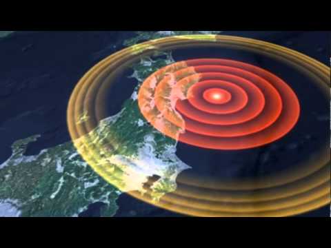
- 🔍 The earthquake's epicenter was in the Japan Trench, where one tectonic plate buckles under another, causing a 500 km long rupture.
- 🏙️ Tokyo's skyscrapers swayed due to the earthquake, highlighting the far-reaching effects of such a massive seismic event.
- 📉 The Great Tohoku Earthquake was the largest in Japan's history, causing the coastline to drop by a meter and shifting the main island.
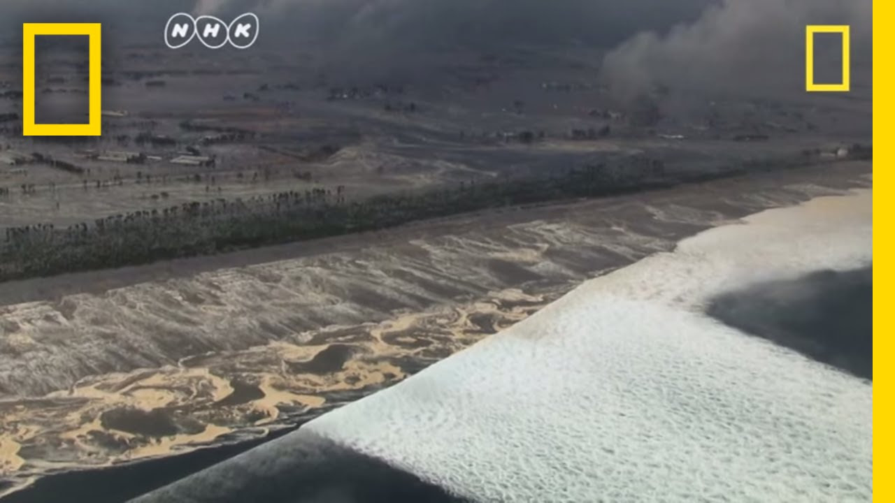
- 🌊 The earthquake generated a massive tsunami, which, despite extensive sea walls, caused significant damage and loss of life.
- 🔬 Geologists are studying historical sediments to better understand past tsunamis and improve future disaster prevention plans.
- 🏞️ The discovery of mud deposits inland suggests that past tsunamis may have been more extensive than previously thought.
- 🌊 The 2011 tsunami's inundation limits were underestimated, which has implications for the planning and construction of critical infrastructure like airports.
- 🔍 The tsunami's behavior in different coastal environments, such as enclosed bays and valleys, can significantly amplify its height and impact.
- 🔬 International research is uncovering the role of low friction in the fault due to slippery clay, which can lead to sudden and large earthquakes.
- ⚠️ The increased strain on the Kanto seismic corridor post-2011 earthquake has heightened the risk of a major seismic event in the Tokyo area.
Q & A
What was the magnitude of the earthquake that hit Japan in March 2011?
-The earthquake in March 2011 had a magnitude of 9, making it one of the largest ever recorded in Japan's history.
Why were seismologists surprised by the 2011 earthquake in Japan?
-Even though Japan has one of the best earthquake research programs in the world, seismologists were surprised by the size and scale of the 2011 earthquake, as it exceeded previous predictions.
How did the 2011 earthquake affect Japan's coastline and main island?
-The earthquake dropped the level of Japan's northeastern coastline by about a meter and shifted the entire main island of Japan to the east by up to 4 meters.
How did the earthquake affect the Earth's axis and Antarctica?
-The shock from the earthquake was so great that it knocked the Earth off its axis and caused giant icebergs to break off from Antarctica.
What was the role of the sea walls and tsunami barriers during the 2011 tsunami?
-Many people believed they were protected by Japan's sea walls and tsunami barriers, but the 8-meter tsunami wave exceeded the barriers, causing widespread devastation and loss of life.
What discovery has changed the way scientists interpret the geological record of past tsunamis?
-Scientists discovered that mud, finer than sand, can be carried further inland by tsunami waves. This finding revealed that the true inundation limits of past tsunamis were underestimated.
How did the 2011 tsunami influence the design of new infrastructure, like the Sendai Airport?
-The discovery that previous tsunami limits were underestimated suggests that infrastructure like the Sendai Airport may have been built in safer locations had the true extent of past tsunamis been known.
What is the significance of smectite clay in understanding the 2011 earthquake?
-Smectite clay, a deep-sea sediment with very low friction, played a key role in the sudden and large slip of the fault during the earthquake, contributing to the massive magnitude of the event.
How has the 2011 earthquake increased the seismic risk for Tokyo?
-The 2011 earthquake increased strain on the Kanto seismic corridor, which surrounds Tokyo, raising the probability of a large earthquake (magnitude 7 or greater) occurring in the city from 7% to 17%.
What are the ongoing challenges in predicting future earthquakes and tsunamis?
-Despite advances in understanding seismic activity, predicting the timing and magnitude of future earthquakes and tsunamis remains difficult due to factors like unpredictable friction levels and the complexity of subduction zones.
Outlines
🌏 The Unpredictability of Earthquakes in Japan
Japan, known for its seismic and hotspot activity, was caught off guard by the massive earthquake in March 2011, despite having one of the best earthquake research programs globally. The earthquake, a 9 magnitude mega thrust, occurred along a 500 km fault line in the Japan Trench. The unexpected scale of the fault movement, estimated at 50 to 60 meters, led to significant geographical changes, including the eastward shift of Japan's main island by up to 4 meters. The quake also had global effects, such as knocking the Earth off its axis and causing icebergs to crack off Antarctica. The tsunami that followed, despite the presence of sea walls and barriers, resulted in significant loss of life and damage, highlighting the challenges of predicting and preparing for such natural disasters.
🔍 Reevaluating Tsunami Risks from Geological Evidence
The script discusses the importance of looking beyond recent history to understand the risk of tsunamis. Geologist Kisa Goto and his team study sediment cores to uncover evidence of past tsunamis. They found that the 2011 tsunami's inundation was significantly greater than previous estimates, with mud deposits indicating that the water reached further inland than sand deposits suggested. This discovery has implications for disaster prevention planning and infrastructure development, such as the Sendai airport, which was rebuilt post-tsunami. The team also uses computer models and video evidence to understand the flow speed and direction of the tsunami, which is crucial for predicting future events. The investigation also extends to the Sanriku Coast, where the tsunami's behavior was influenced by the geography, and to the discovery of boulders that provide clues about past tsunamis, including the potential for larger and more frequent earthquakes than previously thought.
🌊 The Role of Friction in Earthquake Frequency and Impact
This section delves into the role of friction in the frequency and intensity of earthquakes. Seismologist Jim Mori leads a project that investigates the fault's frictional properties, discovering that the presence of slippery deep-sea sediments, specifically a clay called smti, can cause sudden and large slips. This understanding challenges the predictability of earthquake intervals and highlights the potential for more frequent and impactful quakes. The increased strain on the Kanto seismic corridor post-Tohoku quake has doubled the likelihood of a magnitude 7+ earthquake hitting Tokyo in the coming years. The narrative emphasizes the need for engineers and planners to consider geological history to mitigate the risks associated with future earthquakes and tsunamis, as the geological evidence suggests that the threat of such events is more unpredictable than previously believed.
Mindmap
Keywords
💡Seismic
💡Tectonic Plate
💡Mega Thrust Earthquake
💡Inundation Limits
💡Sediment Cores
💡Geological Evidence
💡Tsunami
💡Subduction Zone
💡Friction
💡Seawalls
💡Disaster Prevention Plan
Highlights
Japan's earthquake preparedness was challenged by the unprecedented size of the 2011 earthquake.
The 2011 Tohoku earthquake was a magnitude 9 mega thrust event, the largest ever recorded in Japan.
The earthquake moved the coastline by about a meter and shifted Japan's main island to the east.
The tsunami caused by the earthquake was unexpected in its scale, despite extensive sea walls.
Geological evidence suggests that past tsunamis were larger than previously thought, indicating underestimation in historical data.
Mud deposits found inland are a key indicator of past tsunamis' reach, suggesting they traveled further than sand deposits alone would indicate.
The 2011 tsunami's impact was so severe it influenced the design of new sea walls and disaster prevention plans.
The discovery of a longer inundation limit for past tsunamis challenges current understanding of historical earthquake magnitudes.
International research expeditions are drilling into the Japan Trench to understand the cause of large earthquakes.
Low friction in the fault, caused by slippery clay, explains the sudden and large slip during the 2011 earthquake.
The increased strain on the Kanto seismic corridor post-Tohoku quake raises the risk of a major earthquake in Tokyo.
The probability of a large earthquake in Tokyo has more than doubled since the 2011 quake.
Reconstruction efforts are informed by geological history to better prepare for future disasters.
The new 40 km seawall along the Sendai Coast is designed with the lessons from the 2011 tsunami in mind.
Subduction zones with slippery clay pose an unpredictable threat for giant earthquakes and tsunamis worldwide.
Understanding the geology of subduction zones is crucial for predicting and preparing for large-scale seismic events.
Transcripts
for a country straddling a seismic
hotspot Japan is better prepared for
earthquakes than
most but the sheer size of the one in
March 2011 took even seismologists by
surprise Japan is probably one of the
best earthquake research programs in the
world but we were not able to anticipate
this kind of event and I think a lot of
Si olist lot scientists F felt very
badly about
that 30 km below the Pacific Ocean where
one tectonic plate buckles under another
in the Japan trench the seaf Flor ripped
apart the Fulton zipped along a length
of 500 km in a mega thrust earthquake of
magnitude
9 several hundred kmers away in Tokyo
skyscrapers started to sway
the fault moved a lot more than we've
ever seen before it moved like 50 or 60
M which is just a huge
amount the Great tohoku Earthquake was
the largest ever recorded in Japan's
history it dropped the level of this
Coastline by about a meter and shoved
the entire main island of Japan to the
east by up to 4
M so great was the shock it knocked the
Earth off its axis and as the whole
planet shuttered giant icebergs cracked
off
[Music]
Antarctica and of course when you have
that much fault movement on the ocean
floor then you get a very large
tsunami less than an hour after the
Quake a massive tsunami slammed into the
northeastern
Coast
tragically many of the 18 A2 thousand
people killed or still missing must have
believed they were protected by the
world's biggest network of sea walls and
tsunami
[Applause]
barriers this is the highest hill in
Yuri AGA District so it was a natural
place for people to evacuate to when the
tsunami hit but even on top of this hill
the wave was over my head
[Music]
hundreds died here when the 8m tsunami
raced up the nearby River and swept away
the town and fishing
[Music]
port so how do we know if this
catastrophe was a rare event or one that
could happen again
soon to find out needs a much deeper
view of History Way Beyond the last
century or so our geological evidence is
not well Incorporated in uh disaster
prevention plan so now uh we are
thinking uh to go back further to
several thousand years and then making a
disaster prevention plan for future
tsunam risk
[Music]
assessment geologist Kisa goo reads the
prehistoric record of tsunami from what
they've written into the
landscape like time capsules old
sediments hold evidence about the reach
of tsunamis in the distant
[Music]
past his team samples hundreds of
settlement cores in lines across the
Sendai plain of Northern
Japan our Transit is coming from the the
shore and then passing through here
to um let's say three km farther Inland
from here more than a thousand years ago
a mega tsunami called called Jan tore
through here amid the dust and Rubble of
reconstruction work Gotto shows me Jan's
geological fingerprint in one of his
sediment cores this sun layer is
deposited by the 2011 toi tsunami band
you can see a yellow sun here so it's
probably uh 161 K tsunami deposit so
that was the samurai AG on here and then
this is a 869 Jan uh
deposit so that's
1,145 years ago that's right
yeah before 2011 the inundation limits
for ancient tsunami were defined by the
end of the sand
layer but the recent tsunami has changed
how scientists interpret the geological
record we found that the sun sickness is
30 cm in the coastal area then it's
sinning and sinning for the inland
while the sand here stopped 2.8 km in
land the water continued much further to
4.5 km so then there is a big gap
between the sand uh limit and also the
the water limit so we need to think how
to fill this Gap you looking for the
missing set that's right yeah and that
Missing Link is mud finer than sand it's
carried further Inland by the wave so
the height of the tsunamis are likely to
be bigger than previously thought yeah
that's right yeah it could
be so uh in in case of the 2011 deposit
sand distribution is just uh
60% of the tsunami inundation um
limit discovering mud in land nearly
half as far again as the sand is a
crucial clue it means the inundation
limits of previous meat tsunami have
been underes estimated and if their true
size had been known maybe the
International Airport would have been
built somewhere else the Sendai airport
has been rebuilt since the tsunami sent
cars and trees hurtling through here but
a graphic reminder remains of the horror
of that day a water level more than 3 m
High informed by their siment CES and
measurements of flow depth daa sugara
recreates the 2011 tsunami in a computer
model now H this is the primary part of
the main wave and this SC shows the
sediment concentration within the water
for the first time the videos provide
information he can use to validate his
simulation it's very important video
provides us the good estimate of flow
speed and also the temporal change of
flow Direction and so many
things further north on the San Ru Coast
the jagged Coast line even looks like
giant
waves the enclosed Bays made the tsunami
behave much differently than on the flat
Coastal
plane we at sea level this seaw wall is
10 m
High here was a gate and it's removed by
Itami so it's just smashed the gate it
was coming over the wall and this narrow
Valley it must have been like water
pouring too quickly into a funnel yeah
so water concentrated and and getting
higher and higher how high did it go uh
it said around 28 M 28 M so that's 10 m
28 M around the edge of this Valley
that's right can you see traces of that
along the mhm there you can see the
fence and it is partly broken so that
means that the tsunami reached uh
somewhere on the top of the of the
fence the current was so strong it
rolled massive Boulders far in land have
you been able to estimate the velocity
of the water flow here yeah so we use
the border to estimate how fast camic
current is required and it should be uh
faster than 9 m/ second 9 m a second so
roughly 30 km an hour that's right yeah
that's faster than most people can run
to almost uh 1 kilm from the coast
line further up the valley is one of the
boulders from the 2011 tsunami the team
estimates its mass and calculates the
flow speed needed to wash it
here and just nearby is an even larger
Boulder that locals say has always been
here A Relic from a tsunami in
prehistoric times possibly
Jan okay if we can identify the Jan
tsunami idence in the farther north then
we need to extend the
for so that means that the the magnitude
must be much larger and
larger add to that the discovery of a
longer inundation limit for Jun and
there's evidence of a much stronger
earthquake back in 869
ad the model say that the J magnitudes
should be larger than
8.6 so is that fault in the Japan trench
generating magnitude 9 earthquakes Once
In A Thousand Years or in a more random
patternn
the surprising answer lies deep
offshore an international Expedition has
been drilling into the fault in water 7
km deep to investigate the cause of its
massive
slip seismologist Jim Mori is one of the
Project's
leaders one of the most important things
that is not at all well understood in
seismology is friction how easily or how
hard does it it take or how much force
does it take to move the fault they
found friction in The Fault to be very
low because of a layer of deep sea
sediments that's very
slippery these very soft muds one thing
we've identified is something that's
called smti smti is a well-known clay
and it's well known for its very low
frictional property a lubricated fault
explains why the slip was so sudden and
large and how intervals between
magnitude n Quakes may not be constant
this complication is also driven by this
frictional level these low low slip
environments which sort of sort of can
go at almost any time once you get an
earthquake
started and the KnockOn effects are
major Tokyo is surrounded by a belt of
fols called the Kanto seismic Corridor
now under greater strain since the
tohoku quake the 32 million residents of
Greater Tokyo have long been bracing for
the next big one and the 2011 earthquake
added to that fear because it increased
the seismic hazards here the chance that
a large shock of more than magnitude 7
will hit Tokyo in the next few years has
now more than
doubled since the main Quake the
probability has risen from 7 to 177% a 1
in six chance these are very low
probability events that probably won't
happen in your lifetime but could and if
they do happen then the consequences are
very
high 3 years on as shattered defenses
are rebuilt the tsunami detectives want
the engineers to take geological history
into
[Music]
account this new seaw wall stretches for
40 km along the Sendai Coast given the
he of the 2011 tsunami MH is this seaw
wall big enough um this seaw wall is
designed for much more smaller one it's
7.2 M high but the tsunami wave here was
10
[Music]
m throughout the Pacific Rim wherever
subduction zones have slippery clay
giant earthquakes and mega Army remain
an unpredictable threat this is really
just the beginning uh in terms terms of
understanding the geology and using that
to understand these big slips of um
subduction zones all over the
[Music]
[Applause]
[Music]
world
Browse More Related Video
Fukushima: o dia em que o Japão sofreu um triplo desastre | 21 notícias que marcaram o século 21
March 11, 2011 Japan Earthquake—10th Anniversary—Lessons Learned (educational)
Apakah Gempa Megathrust Bisa Membelah Pulau Jawa?
EARTH, MERCURY, VENUS AND MARS | Update 18 June 2024
What happens when the ‘Big One’ hits Metro Manila? | Look Through: The Big One
Japan's Ticking Time Bomb
5.0 / 5 (0 votes)