Map Skills - Calculating Bearings in a Geography Examination

Geographer Online
10 Nov 201706:34

Summary

TLDRThis educational video teaches viewers how to calculate bearings, a valuable skill for geography examinations like GCSE and A-Level. It explains that bearings offer precise directional guidance, contrasting with compass points. The process involves drawing a north line from the starting point, connecting the two points, and measuring the angle with a protractor. The video emphasizes the importance of starting from the north and measuring clockwise. It also addresses how to handle bearings over 180 degrees, either by adding to 180 or subtracting from 360. The presenter assures that mastering this skill can lead to easy points in exams.

Takeaways

  • 🧭 Bearings are a map skill used to calculate precise directions, which is useful in geographical examinations like the GCSE, CIE, and A-level papers.
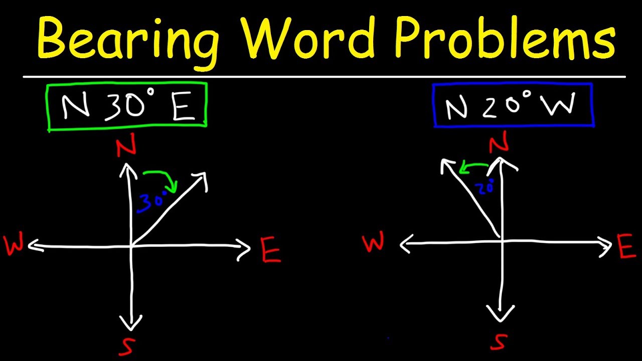
  • 🗣 A bearing is more accurate than compass points, as it specifies the exact direction, not just a general one like 'north east'.
  • 📏 When measuring bearings, always start from the north and measure clockwise to get an accurate direction.
  • 🔢 Bearings are measured in degrees, with North being 0 degrees, East 90 degrees, South 180 degrees, and West 270 degrees.
  • 🔄 Understanding the difference between bearings from point A to B and from B to A is crucial, as the direction and thus the bearing will differ.
  • 📐 To measure the bearing between two points, draw a north line from the starting point and then draw a line connecting the two points.
  • 📏 Use a protractor to measure the angle between the north line and the line connecting the two points to find the bearing.
  • ⚙️ If the angle exceeds 180 degrees, you can either add 180 degrees to the angle or subtract the angle from 360 degrees to find the bearing.
  • 📝 It's important to be precise when calculating bearings, ensuring the protractor's center is on the intersection of the north line and the line connecting the points.
  • 🎓 Mastering the skill of calculating bearings can lead to easy points in geography examinations and is a valuable practical skill.

Q & A

  • What is the primary purpose of calculating bearings in geography?

    -Calculating bearings is a map skill used to determine precise directions, which is extremely useful in practical examinations such as the GCSE, CIE paper, and some A-level papers.

  • How does a bearing differ from a compass point?

    -A bearing provides a specific direction with exact degrees, whereas a compass point is less precise, indicating only general directions like north-east.

  • What is the starting point for measuring a bearing?

    -When measuring a bearing, you always start from the north and measure around clockwise to get an accurate measurement.

  • What is the significance of the 0 degrees bearing?

    -The 0 degrees bearing represents the exact north direction.

  • How do you determine the bearing between two points on a map?

    -To determine the bearing between two points, you draw a north line from the starting point, connect the two points with a line, and measure the angle between the north line and the connecting line using a protractor.

  • Why is it important to identify the starting and destination points when calculating bearings?

    -The bearing from point A to point B will be different from the bearing from B to A, so identifying the correct starting and destination points is crucial for accurate bearing calculations.

  • What should you do if the measured angle exceeds 180 degrees?

    -If the angle exceeds 180 degrees, you can either measure the angle again going clockwise and add 180 degrees to it, or measure it counterclockwise and subtract it from 360 degrees to find the correct bearing.

  • What is the bearing from point A to point B if the measured angle is just shy of 135 degrees?

    -The bearing from point A to point B would be approximately south-east or precisely 135 degrees.

  • How can you ensure accuracy when measuring bearings?

    -Ensure accuracy by identifying the starting and destination points, drawing a north line, connecting the points, and using a protractor to measure the angle precisely.

  • What is the recommended approach to mastering the skill of calculating bearings?

    -Mastering the skill of calculating bearings involves understanding the procedure, practicing with a protractor, and being precise in identifying starting points and measuring angles.

  • Why are bearings an important skill in geography examinations?

    -Bearings are an important skill in geography examinations because they allow for precise navigation and direction measurement, which can lead to easy points in practical and theoretical exams.

Outlines

00:00

🗺️ Understanding Bearings in Geography

This paragraph introduces the concept of bearings in geography, emphasizing its importance in practical examinations like GCSE and A-level papers. Bearings are more precise than compass points, providing exact directions rather than general ones. The process of measuring bearings is explained, starting from the north and moving clockwise. The paragraph also discusses how to interpret bearings in relation to compass points, such as North East being approximately 45 degrees. It highlights the significance of identifying the starting and destination points when calculating bearings between two points, like point A and point B, and the importance of accuracy in measurement.

05:00

📏 Measuring Bearings: Techniques and Tips

The second paragraph delves into the practical steps for measuring bearings. It instructs to draw a north line from the starting point and connect it to the destination point. The angle between the north line and the line connecting the two points is measured using a protractor to find the bearing. The paragraph clarifies that if the angle exceeds 180 degrees, one can either add 180 to the angle or subtract it from 360 to find the correct bearing. It stresses the importance of precision and the correct procedure in measuring bearings, which can be a challenging but rewarding skill for geographical assessments. The video concludes with an encouragement to practice this skill for success in exams and an invitation to subscribe for more geography content.

Mindmap

Keywords

💡Bearing

A bearing in the context of the video refers to a specific direction or angle from one point to another, often used in navigation and geography. It is more precise than compass points, which are broader (e.g., north-east). Bearings are measured in degrees and are crucial for accurately determining the direction one must travel. In the video, bearings are calculated by drawing a line from the starting point to the destination and measuring the angle this line makes with the north line.

💡Compass Point

A compass point is a general direction indicated on a compass, such as north, south, east, or west. The video script contrasts compass points with bearings, highlighting that while compass points give a rough direction, bearings provide exact directional measurements. For example, 'north-east' is a compass point, whereas a bearing would specify the precise degree, like 45 degrees.

💡North Line

The north line mentioned in the script is a conceptual line drawn from the starting point directly towards the north, which serves as a reference for measuring bearings. It is essential in the process of calculating bearings as it helps to establish the 0-degree reference point from which the angle to the destination is measured.

💡Protractor

A protractor is a tool used for measuring angles. In the video, it is used to accurately measure the angle between the north line and the line connecting two points to determine the bearing. The script emphasizes the importance of placing the protractor's center on the point of origin and aligning the 0-degree mark with the north line to ensure precision.

💡Clockwise

The term 'clockwise' is used in the video to describe the direction in which one should measure the angle when calculating a bearing. It means to measure the angle from the north line towards the right, following the direction of the hands of a clock. This is important for obtaining the correct bearing measurement.

💡Starting Point

The starting point, also known as the point of origin, is the initial location from which a bearing is measured. The video script stresses the importance of identifying the correct starting point, as the bearing from point A to point B will be different from the bearing from point B to point A.

💡Destination

The destination in the context of bearings is the final or target location towards which the bearing is measured. The video explains that the bearing's calculation is dependent on the relationship between the starting point and the destination, as the direction and angle will differ depending on the order of these points.

💡Degrees

Degrees are units of measurement for angles, with a full circle being 360 degrees. The video script uses degrees to express the precision of bearings, such as 45 degrees for north-east or 135 degrees for a specific bearing from one point to another. Degrees are fundamental to the calculation and expression of bearings.

💡Off Line

An off line in the video refers to the line that is drawn from the starting point towards the destination. It is used in conjunction with the north line to measure the angle that represents the bearing. The script describes the process of drawing this line to connect the two points of interest.

💡Practical Element

The practical element mentioned in the script refers to the hands-on or applied aspect of an examination, such as those in geography where students might need to demonstrate their ability to calculate bearings. The video is geared towards helping students master this skill for success in exams that include such practical components.

Highlights

Introduction to calculating bearings, a crucial map skill for geography examinations.

Bearings provide precise direction compared to compass points.

Bearings are measured starting from north and going clockwise for accuracy.

Examples of bearings and their corresponding compass points, such as North East at 45 degrees.

The importance of identifying the starting and destination points when calculating bearings.

Procedure for measuring bearings: drawing a north line and connecting points.

Using a protractor to accurately measure the angle between the north line and the line connecting two points.

How to calculate bearings when the angle exceeds 180 degrees.

Two methods for calculating bearings when angles exceed 180 degrees: adding to 180 or subtracting from 360.

The necessity of precision in bearing calculations.

Practical demonstration of calculating bearings from different starting points.

The impact of starting point on the bearing calculation and its result.

Tips for mastering the skill of calculating bearings for examinations.

Encouragement to practice and the benefits of mastering the bearings skill.

Invitation to like and subscribe for more geography-related content.

Closing remarks and well wishes for the viewers.

Transcripts

play00:01

hello everyone in this geography

play00:04

skills-based video we're going to be

play00:06

looking at how to calculate bearings

play00:07

this is a map skill and it's extremely

play00:10

useful on any examination where you have

play00:13

a practical element for example the GCSE

play00:16

CIE paper and some of the a level papers

play00:19

as well

play00:30

when using bearings there are a few

play00:32

things you need to know first a bearing

play00:35

actually tells us a direction so when

play00:37

you're looking at the bearing on a map

play00:39

you're looking at a direction that

play00:40

you're going it's a lot more accurate in

play00:43

a compass point whereas a compass point

play00:45

only tells you for example north east

play00:47

are the bearing can tell you exactly the

play00:50

precise northeast direction that you're

play00:53

going to be going in in addition to this

play00:55

when you're measuring a bearing you have

play00:57

to always start from the north and go

play00:59

around clockwise for you to get an

play01:01

accurate measurement

play01:08

over here you can see approximately what

play01:11

these bearings mean especially compared

play01:13

to the matching compass points for

play01:16

example and North East is approximately

play01:18

45 degrees east 90 degrees south hundred

play01:22

eighty west 270 and North is actually

play01:25

zero degrees and if you would fill in

play01:28

all the gaps you can go down to a very

play01:30

very precise direction

play01:36

now for example if you have two points

play01:39

as you can see on the slide point a and

play01:42

point B and you ought to find the

play01:45

bearing from these two points it's

play01:47

extremely important to read the question

play01:49

carefully and to figure out which is

play01:52

starting point and which is the

play01:53

destination for example the bearing of A

play01:56

to B would be completely different from

play01:59

the bearing of B to a

play02:06

so when it comes to measuring these

play02:08

bearings and you wanting to find the

play02:10

exact degrees there is a certain

play02:12

procedure you need to follow we're going

play02:14

this diagram from point A to point B the

play02:17

first thing you need to do is you need

play02:19

to draw an off line the North line is a

play02:22

point leading from the point of origin a

play02:24

in this case directly north to 0 degrees

play02:29

after we've drawn the North line you

play02:32

then need to connect the two points the

play02:35

a and the B and draw a line connecting

play02:37

them you then measure the angle between

play02:40

the North line and the line that

play02:43

connects 8 B and this is your bearing

play02:52

it is important to be

play02:54

sighs when calculated in the bearings so

play02:57

what you need to do is when you've done

play02:58

all the points that I mentioned in the

play03:00

previous slide you take your protractor

play03:02

you make sure that the center of the

play03:04

protractor is exactly on the point where

play03:08

the North line intersects the line

play03:10

connecting the a and B point you make

play03:12

sure the zero the beginning point of

play03:14

your protractor is on the North line and

play03:16

then you measure the angle round and you

play03:19

can see over here that the angle is just

play03:21

a little bit shy of 135 degrees that

play03:25

gives us a bearing of approximately

play03:28

south east or more precisely 135 degrees

play03:37

I mentioned previously that if you're

play03:41

looking at the bearing it's very

play03:42

important to know the starting point

play03:44

while these are exactly the same lines

play03:47

the a and B but this time if I say I

play03:50

want you to find the bearing from B to a

play03:52

notice we do it a little bit differently

play03:54

and the result is definitely not going

play03:56

to be a hundred and thirty five degrees

play03:58

so you follow the same procedure again

play04:00

you draw an off line from the starting

play04:03

point this case being B and then you

play04:06

connect the B to the a and you want to

play04:09

measure clockwise going round the angle

play04:12

from the North line all the way to the

play04:15

line that connects the two points

play04:23

however in this instance you'll notice

play04:26

that when you place your protractor are

play04:28

to measure these lines you'll notice

play04:30

that the angle exceeds a hundred and

play04:32

eighty degrees and therefore you have to

play04:34

do something a little bit different

play04:42

in this instance you're left with two

play04:45

different options you can measure the

play04:48

angle again going clockwise and you'll

play04:51

find out the angle is 135 degrees and

play04:54

then you have to remember that the angle

play04:56

has already exceeded 180 degrees so if

play05:00

135 plus 180 makes 315 degrees or

play05:05

alternatively if you're very confident

play05:07

you can work this out faster and what

play05:10

you do is you measure any angle that

play05:12

exceeds 180 degrees you measure it

play05:15

counterclockwise but if you measure it

play05:18

counterclockwise you're not adding to

play05:21

180 degrees you - it away from the total

play05:24

angle of a circle 360 degrees which will

play05:28

give you exactly the same result so we

play05:30

can see here if we measure

play05:31

counterclockwise we will measure 45

play05:35

degrees and therefore if we take away 45

play05:39

degrees from 360 we're left with 315

play05:42

degrees again whichever way you prefer

play05:44

to do it we'll find the same result you

play05:48

just have to remember be precise find

play05:51

your starting point and then your point

play05:53

of destination

play05:54

draw your knopf line connect the lines

play05:56

together and then work out what the

play05:59

angle is using a protractor

play06:04

this can

play06:06

bearings is actually quite an easy skill

play06:08

it tends to trip a lot of people up but

play06:11

once you master it and you figure out

play06:14

the different stages um it's a very easy

play06:16

points for you to get in your

play06:17

examination I hope you've enjoyed this

play06:20

video and if you found it useful please

play06:22

like the video and if you'd like to see

play06:25

more content subscribe for future

play06:27

geography videos thank you very much for

play06:30

watching and I hope you have a really

play06:32

great day

Rate This

5.0 / 5 (0 votes)

相关标签
Bearing CalculationGeography SkillsMap ReadingGCSE ExamA Level ExamCompass PointsDirection FindingNavigation TechniquesEducational VideoGeography Tutorial
您是否需要英文摘要?