G7AP - Week 1 - 1st Qtr - Lokasyon at Pisikal na Katangian ng Timog Silangang Asya
Summary
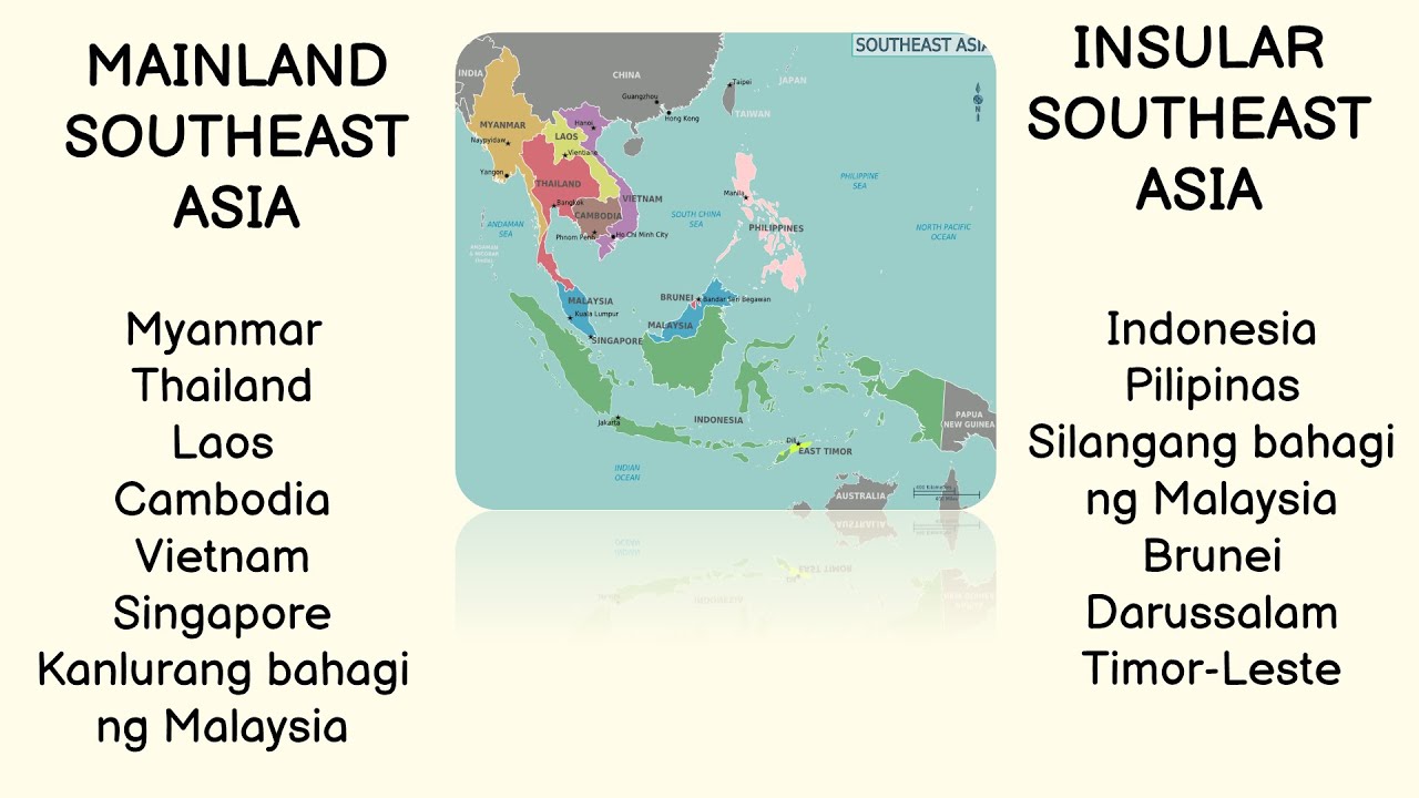
TLDRThe video explores Southeast Asia in a Social Studies 7 lesson, focusing on its geography, physical characteristics, and economic significance. It distinguishes between Mainland Southeast Asia—comprising Myanmar, Laos, Thailand, Vietnam, Cambodia, and part of Malaysia, known for agriculture—and Insular Southeast Asia, including the Philippines, Indonesia, Malaysia, Singapore, Brunei, and Timor-Leste, rich in fisheries. The region lies on the Pacific Ring of Fire, featuring active volcanoes and earthquakes. Students are guided to observe maps, understand natural resources, and engage creatively by drawing or photographing local sites and crafting environmental protection slogans, linking geographic knowledge to cultural and ecological awareness.
Takeaways
- 😀 The script discusses the location and physical characteristics of Southeast Asia in relation to mainland and insular regions.
- 😀 Mainland Southeast Asia consists of countries like Myanmar, Laos, Thailand, Vietnam, Cambodia, and parts of Malaysia.
- 😀 Insular Southeast Asia includes the Philippines, Singapore, Indonesia, Brunei, Timor-Leste, and parts of Malaysia.
- 😀 The physical geography of Southeast Asia is influenced by its position on the Pacific Ring of Fire, which causes active volcanoes and frequent earthquakes.
- 😀 Mainland Southeast Asia is known for its agricultural richness, while Insular Southeast Asia is famous for its abundant marine resources.
- 😀 Southeast Asia is geographically divided into mainland and insular regions, each with unique characteristics and advantages.
- 😀 The region is also rich in bodies of water such as the South China Sea, Celebes Sea, Malacca Strait, and the Pacific Ocean, vital for trade and economic activities.
- 😀 The Southeast Asian region is known for being made up of several island nations or archipelagos.
- 😀 The main learning objectives include understanding the physical geography of Southeast Asia, its location, and its role in global trade.
- 😀 The script encourages students to reflect on the region's environmental significance by creating a slogan and capturing a picture of a place they admire in Southeast Asia.
Q & A
What is the main focus of the lesson in this script?
-The lesson focuses on the geography and physical characteristics of Southeast Asia, specifically examining the distinction between the mainland and insular regions.
Which countries are part of Mainland Southeast Asia?
-Mainland Southeast Asia includes Myanmar, Laos, Thailand, Vietnam, and Cambodia. Some may also consider the western part of Malaysia as part of this region due to its proximity to Thailand.
What is the defining characteristic of Insular Southeast Asia?
-Insular Southeast Asia consists of island nations that are surrounded by the sea. Countries in this region include the Philippines, Indonesia, Brunei, Singapore, East Timor (Timor-Leste), and Malaysia's island regions.
What is the 'Ring of Fire,' and how does it affect Southeast Asia?
-The Ring of Fire is a region in Southeast Asia that is highly prone to volcanic activity and earthquakes. It is a part of the Pacific Ocean's tectonic plate boundary, causing frequent natural disasters such as volcanic eruptions and earthquakes.
What are the key economic resources of Mainland Southeast Asia?
-Mainland Southeast Asia is rich in agricultural resources, with its economy primarily driven by agriculture. The fertile lands allow for the cultivation of various crops, contributing significantly to the region's economy.
How does Insular Southeast Asia contribute to the economy, especially in terms of resources?
-Insular Southeast Asia's economy benefits greatly from fishing, as the region is surrounded by seas and oceans. This maritime environment provides abundant marine resources that support the fishing industry.
What role do seas and oceans play in the region's economy?
-Seas like the South China Sea and the Celebes Sea, along with straits such as the Malacca Strait, play a significant role in regional trade. These waterways facilitate the movement of ships and contribute to a thriving maritime trade economy.
What was the significance of the Southeast Asian nations forming the Association of Southeast Asian Nations (ASEAN)?
-The formation of ASEAN allowed the countries of Southeast Asia to cooperate more effectively in areas such as trade, economy, and regional stability, strengthening their collective political and economic influence.
What natural feature contributes to the high level of volcanic activity in Southeast Asia?
-Southeast Asia is part of the Pacific Ring of Fire, which is responsible for the region's frequent volcanic eruptions and earthquakes due to the tectonic plate movements in the area.
What type of interactive activities are students encouraged to do based on this lesson?
-Students are encouraged to create a visual representation of a place they are proud of, either through a drawing or photograph, and also to compose a slogan related to the importance of protecting the environment.
Outlines

This section is available to paid users only. Please upgrade to access this part.
Upgrade NowMindmap

This section is available to paid users only. Please upgrade to access this part.
Upgrade NowKeywords

This section is available to paid users only. Please upgrade to access this part.
Upgrade NowHighlights

This section is available to paid users only. Please upgrade to access this part.
Upgrade NowTranscripts

This section is available to paid users only. Please upgrade to access this part.
Upgrade NowBrowse More Related Video

HEOGRAPIYANG PISIKAL NG TIMOG-SILANGANG ASYA (MATATAG) #matatagcurriculum
AP7 MATATAG Q1 Week 1 LOKASYON AT PISIKAL NA KATANGIAN NG TIMOG SILANGANG ASYA with POWERPOINT

Heograpiya ng Timog Silangang Asya Quarter 1 Week 1 Matatag Curriculum
Bentuk bentuk Kerjasama antar negara #Geografi Kelas XII

AP7 MATATAG Q1 Week 3-1 Ang Heograpiyang Pantao ng Timog Silangang Asya WIKA with PPT and DLL
Landscape Approach of Human #geography || By-Sagarika Nag
5.0 / 5 (0 votes)