Information on Paper Charts used on ships for navigation
Summary
TLDRThis video explains the essential information found on paper nautical charts, guiding navigators in their use. It covers various elements such as chart titles, scales, depth and height measurements, navigational warnings, tidal streams, light characteristics, and compass roses. The video also touches on chart corrections, geodetic datums, and the importance of selecting the right scale for different navigation situations. It emphasizes the need for updating charts and understanding their reliability. The host encourages viewers to learn about paper charts in stages and expresses gratitude for their positive feedback.
Takeaways
- 😀 Paper charts contain essential information for safe navigation, including chart title, scale, and geodetic data.
- 😀 Chart titles help identify the specific chart and are clearly printed to avoid obscuring important information.
- 😀 The scale of a chart is crucial for understanding its coverage area, with large-scale charts focused on small areas and small-scale charts providing broader coverage.
- 😀 Depth and height information is provided in meters, with specific details on chart datum and tidal heights.
- 😀 Navigational marks are included on the chart, showing important information like the association of maritime regions and related navigational warnings.
- 😀 Geodetic data, including the sources and date of surveys, are essential to understand the accuracy of the chart.
- 😀 Warning notes on the chart inform users of navigational hazards, such as wrecks and rate changes, ensuring safe course plotting.
- 😀 Different chart scales are used depending on the proximity to the coastline, with larger scales used for coastal navigation and smaller scales for open ocean voyages.
- 😀 Latitude and longitude scales are provided for precise distance plotting, with attention to the changing scale of latitudes as one moves from the equator to the poles.
- 😀 The chart provides light characteristics, tidal stream data, and reference to larger scale charts for specific navigation needs.
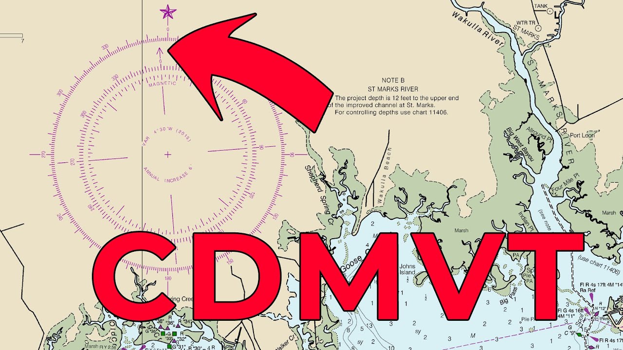
- 😀 The reliability diagram indicates the accuracy of the hydrographic data, and the compass rose helps with direction plotting and course navigation using true north.
Q & A
What is the importance of the chart title on a paper chart?
-The chart title is crucial as it provides the identifier for the chart, ensuring that the navigator knows exactly which chart they are using. It is printed clearly to avoid obstructing any important navigational details.
How does the scale on a paper chart affect navigation?
-The scale of a chart determines the level of detail. A larger scale provides a detailed view of a smaller area, useful for navigating close to shore, while smaller scale charts offer a broader overview for open sea navigation.
What is the Mercator projection, and how does it relate to the chart?
-The Mercator projection is a method of representing the Earth's spherical surface on a flat chart. It enables accurate plotting of straight-line courses, although it distorts areas at higher latitudes.
How is depth information represented on paper charts?
-Depth information is shown in meters and is reduced to a chart datum, which is usually the level of the Indian Spring Low Water. Drying heights are also indicated for areas where the water level is low.
What is the significance of the tidal stream data on a paper chart?
-Tidal stream data shows the direction and speed of tidal currents in a specific area. This helps navigators account for these currents when plotting courses to ensure accurate navigation.
Why is the geodetic datum important for paper charts?
-The geodetic datum defines the reference system for positioning on the chart. In the script's example, it is a Mercator chart, and the datum helps in ensuring that the chart's geographic data aligns correctly with real-world coordinates.
What role do chart corrections play in maintaining navigational safety?
-Chart corrections are updates made to a chart after it has been published. These corrections may involve changes due to new surveys or navigational hazards, and they ensure that the chart remains accurate for safe navigation.
What is the purpose of a compass rose on a paper chart?
-A compass rose provides a reference for direction, showing true north and magnetic north. It helps navigators plot courses and measure bearings accurately, accounting for magnetic variation.
How does latitude and longitude scaling differ on a Mercator chart?
-On a Mercator chart, latitude lines are spaced farther apart as one moves from the equator to the poles. This change is important for distance plotting, as the scale of latitude lines varies with the change in latitude.
What is the role of the reliability diagram in a paper chart?
-The reliability diagram provides information about the accuracy of the hydrographic data used to create the chart. It helps assess the reliability of soundings and the spacing of soundings, which is critical for safe navigation.
Outlines

This section is available to paid users only. Please upgrade to access this part.
Upgrade NowMindmap

This section is available to paid users only. Please upgrade to access this part.
Upgrade NowKeywords

This section is available to paid users only. Please upgrade to access this part.
Upgrade NowHighlights

This section is available to paid users only. Please upgrade to access this part.
Upgrade NowTranscripts

This section is available to paid users only. Please upgrade to access this part.
Upgrade NowBrowse More Related Video

#pelayaran #navigasipelayaran SIMBOL SIMBOL PADA PETA LAUT

Top Data Visualizations Explained | Know When to Use Each!
How To Correct Magnetic Compass Bearings

ATPL General Navigation - Class 6: Distance.
An explanation of equipment and tools used when updating an ADMIRALTY Standard Nautical Chart

How To Do Patient Intake | Medical Assisting Training| Patient Triage | Patient Interview
5.0 / 5 (0 votes)