Review Garmin gpsmap 585 plus, bisa mengetahui ikan di dasar air dan koordinat. simak penjelasanya
Summary
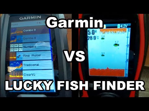
TLDRIn this video, the presenter reviews the Garmin GPSMAP 585 Plus, highlighting its compatibility with fish finders and eco-sounders. The GPS can store up to 10,000 waypoints and comes with preloaded nautical charts. The video demonstrates the device's sonar settings, including traditional and ClearVu modes, along with detailed depth readings. The GPS's detailed mapping feature is also explored, showcasing its full Asian coverage. The presenter explains how to save coordinates and navigate to them, concluding by providing purchasing links for viewers interested in the device.
Takeaways
- 😀 The Garmin GPSMAP 585 Plus supports up to 10,000 waypoints, allowing users to save and navigate to a large number of locations.
- 😀 It comes preloaded with maritime maps, making it ideal for marine navigation.
- 😀 The device offers a simulated mode, allowing users to preview the map and settings before heading out on the water.
- 😀 Sonar settings are customizable, with options for adjusting scroll speed and enabling fish symbols for easier navigation and fish detection.
- 😀 The traditional sonar mode displays detailed fish symbols, while ClearVu provides a more minimalistic point-based representation.
- 😀 Depth readings are shown in meters, helping users track water depth accurately, with adjustable settings for different detail levels.
- 😀 The device has an option for 2D and 3D map viewing, offering flexibility in navigation and display preferences.
- 😀 Users can create and save coordinates for specific locations, such as fishing hotspots, by pressing the 'Mark' button and naming the waypoint.
- 😀 The Garmin GPSMAP 585 Plus includes a built-in feature for saving and displaying coordinates with customized symbols for easy identification.
- 😀 The device offers coverage for all of Asia, ensuring users can navigate vast regions and access detailed maps worldwide.
Q & A
What is the Garmin GPS Map 585 Plus e designed for?
-The Garmin GPS Map 585 Plus e is designed for marine navigation and is compatible with fish finders and echo sounders, making it ideal for boating and fishing activities.
How many waypoints can the Garmin GPS Map 585 Plus e store?
-The Garmin GPS Map 585 Plus e can store up to 10,000 waypoints, allowing users to save important locations.
What kind of maps does the Garmin GPS Map 585 Plus e come with?
-The device includes marine charts covering all of Asia, providing detailed nautical maps for navigation.
What happens when the Garmin GPS Map 585 Plus e is turned on?
-When powered on, the Garmin GPS Map 585 Plus e displays the initial interface, and users can set it to simulation mode to preview the display of marine charts and other settings.
How can you switch between sonar modes on the Garmin GPS Map 585 Plus e?
-To switch between sonar modes, you access the sonar settings through the menu. You can choose between traditional sonar, clearvu, or a 3D mode based on your preferences.
What is the difference between traditional sonar and clearvu modes?
-Traditional sonar shows fish and depth using symbols, while clearvu mode displays fish and depth as dot-like marks on the screen, offering a clearer, more simplified view.
How do you adjust the map display settings for better detail?
-To adjust the map display, you enter the menu and change the chart settings to 'more detail,' which will display additional depth information and other relevant details on the map.
Can the Garmin GPS Map 585 Plus e show both GPS and sonar information at the same time?
-Yes, the device allows users to configure the display to show both the GPS navigation map and sonar data simultaneously by adjusting the layout settings.
How can you save a location (waypoint) on the Garmin GPS Map 585 Plus e?
-To save a location, press the 'Mark' button, edit the coordinates and symbol, and then save it. This allows you to return to the spot later by selecting the saved waypoint.
How do you navigate to a saved waypoint on the Garmin GPS Map 585 Plus e?
-To navigate to a saved waypoint, go to the menu, select 'Go To,' and choose the saved waypoint from the list. The device will guide you to the location using GPS coordinates.
Outlines

This section is available to paid users only. Please upgrade to access this part.
Upgrade NowMindmap

This section is available to paid users only. Please upgrade to access this part.
Upgrade NowKeywords

This section is available to paid users only. Please upgrade to access this part.
Upgrade NowHighlights

This section is available to paid users only. Please upgrade to access this part.
Upgrade NowTranscripts

This section is available to paid users only. Please upgrade to access this part.
Upgrade NowBrowse More Related Video
Garmin striker vivid 4cv and Lucky fish finder tutorial #garmin #fishfinder #lucky

I bought them all so that you don't have to! [video 589]

Baseus Particular Digital Display QC+PPS Dual Quick Charger Car Charger 65W Огляд + тест
Can You Use Office 365 on iPad, Productively?

Apple Watch vs Garmin (Don't Waste Your Money)
Samsung Galaxy S24 FE: Official Samsung Cases!
5.0 / 5 (0 votes)