ATPL General Navigation - Class 3: Great Circles and Rhumb Lines.
Summary
TLDRIn this educational video, Grant explains the concept of great circles and rhumb lines in aviation. Great circles, which are the shortest paths between two points on a perfect sphere, are often used in flight planning despite the Earth's slight imperfections. These paths appear as curved lines on maps due to the constantly changing direction relative to true north. In contrast, rhumb lines offer a constant track, making them easier to navigate but resulting in longer routes. The video clarifies the difference between the two, noting that at the equator and along meridians of longitude, a rhumb line and a great circle coincide, providing valuable insights for understanding flight paths.
Takeaways
- 🌐 Great circles are the shortest possible distances between two points on the surface of a perfect sphere, and they are often considered equivalent to geodesics on Earth due to its near-spherical shape.
- 🌍 The Earth is not a perfect sphere, but for practical purposes in aviation, this slight difference is usually ignored, treating geodesics and great circles as the same.
- 📍 Great circles always pass through the center of the Earth, which means they cross the equator at some point, known as a 'node'.
- 🔺 The highest point of a great circle's latitude is called the 'vertex', and it is where the circle reaches its maximum latitude before descending on the other side.
- 🔄 The direction of a great circle route is constantly changing because it is a straight line on a curved surface, which results in a variable track.
- 🧭 On a map with a fixed north reference, a great circle route would appear as a curved line due to the constantly changing direction.
- ✈️ The curved line seen on long-haul flight progress maps is actually a great circle route, which is the most direct path between two points on Earth.
- 🛫 A rhumb line, in contrast to a great circle, maintains a constant track angle, making it easier to navigate but resulting in a longer route.
- 🌡️ Rhumb lines are only the same as great circles when they follow a line of latitude or a meridian of longitude, such as at the equator.
- 🌎 The difference in distance between a rhumb line and a great circle becomes more pronounced the further one travels from the equator and the greater the change in longitude.
Q & A
Why does the flight path on a long-haul flight map appear as a curved line instead of a straight one?
-The flight path on a long-haul flight map appears as a curved line because it follows a great circle route, which is the shortest distance between two points on the Earth's surface, and not a straight line.
What is the definition of a great circle?
-A great circle is a circle on the surface of a sphere that has the same center as the sphere, and it represents the shortest path between two points on the surface of the Earth.
How does a great circle differ from a geodesic?
-A great circle is the shortest path on a perfect sphere, while a geodesic is the shortest path on the Earth's surface, which is slightly squished. In aviation, they are often considered the same due to the minuscule difference.
What is the term used for the point where a great circle crosses the equator?
-The point where a great circle crosses the equator is called a 'node'.
What is the highest point of a great circle called?
-The highest point of a great circle, where it reaches its maximum latitude before descending on the other side, is called the 'vertex'.
Why is the direction of a great circle route constantly changing?
-The direction of a great circle route constantly changes because it is a straight line on a curved surface, so as the plane travels along the great circle, its angle relative to the lines of latitude changes.
How does a rhumb line differ from a great circle?
-A rhumb line differs from a great circle in that it maintains a constant track angle relative to true or magnetic north, making it easier to navigate but resulting in a longer route compared to a great circle.
Under what conditions is a rhumb line the same as a great circle?
-A rhumb line is the same as a great circle when the path is along the equator or a meridian of longitude, as these are the only cases where the track angle remains constant.
Why do pilots prefer to follow a rhumb line over a great circle?
-Pilots may prefer to follow a rhumb line because it allows for a constant track angle, making navigation simpler without the need to constantly change direction as with a great circle.
What is the main disadvantage of following a rhumb line compared to a great circle?
-The main disadvantage of following a rhumb line compared to a great circle is that it is a longer route, which can result in increased fuel consumption and travel time.
How can one visualize the difference between a great circle and a rhumb line?
-One can visualize the difference by considering a map where north is always up; a great circle would appear as a curved line due to the constantly changing track, while a rhumb line would appear as a straight line with a constant track angle.
Outlines

This section is available to paid users only. Please upgrade to access this part.
Upgrade NowMindmap

This section is available to paid users only. Please upgrade to access this part.
Upgrade NowKeywords

This section is available to paid users only. Please upgrade to access this part.
Upgrade NowHighlights

This section is available to paid users only. Please upgrade to access this part.
Upgrade NowTranscripts

This section is available to paid users only. Please upgrade to access this part.
Upgrade Now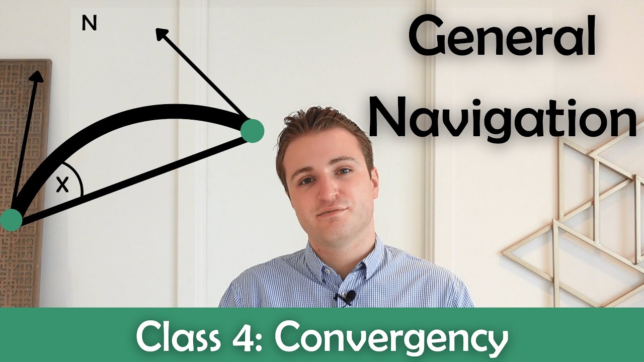


5.0 / 5 (0 votes)