Monitoreo Cultivos con Qgis #4 #qgis
Summary
TLDRThis tutorial demonstrates how to create a monitoring map for infestation levels, specifically focusing on Broca, a pest. It covers using GIS tools like interpolation for mapping infestation data, adjusting visualization settings, and interpreting results. The process involves generating raster layers based on infestation data, applying color bands to identify high and low infestation zones, and analyzing the data to make informed decisions on pest control measures, such as fumigation and traps. The video provides a step-by-step guide for effectively visualizing and responding to infestation levels in a specific area.
Takeaways
- 😀 The process focuses on creating a monitoring map based on infestation data.
- 😀 Interpolation methods are used to generate the monitoring map, specifically statistical interpolation.
- 😀 The interpolation process involves selecting the appropriate layer, in this case, the sample point layer for infestation degree.
- 😀 Distance coefficient settings are left by default, while the extent is adjusted to fit the polygon generated in the project.
- 😀 A raster file is generated to represent the infestation degree, which is then saved permanently for further use.
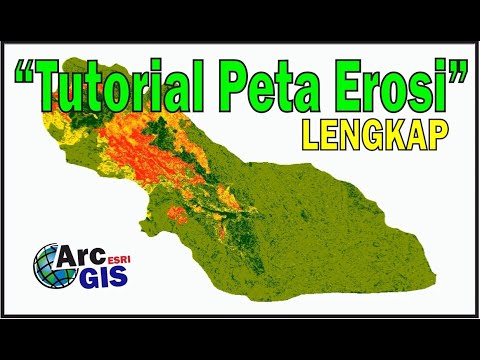
- 😀 The resulting raster file is in grayscale, where darker areas represent lower infestation degrees, and lighter areas show higher infestation levels.
- 😀 Users can change the visualization of the map to pseudo-color to improve interpretation of results.
- 😀 The process includes adjusting the color band to differentiate infestation levels more clearly.
- 😀 The map can be further analyzed by comparing it to the attribute table to verify data and the corresponding infestation degree at specific points.
- 😀 The tool for identifying spatial objects is used to validate the infestation degree at selected points, ensuring accuracy.
- 😀 The final map can guide decision-making, such as whether to fumigate or place traps based on infestation levels, with an emphasis on acting if infestation exceeds 2%.
Q & A
What is the main goal of the process described in the video?
-The main goal is to create a monitoring map that visualizes the infestation levels, specifically the degree of infestation of Broca (a pest), using interpolation methods and GIS tools.
What GIS method is used to create the monitoring map?
-The method used is statistical interpolation, which helps generate a raster map based on point data, such as the infestation degree.
What is the role of the interpolation tool in this process?
-The interpolation tool helps estimate values for locations between sampled points, allowing the creation of a smooth surface that shows the degree of infestation across the entire area.
What type of data is being interpolated in this process?
-The data being interpolated is the degree of infestation, which is represented as a value in the point data (sample points).
How is the extension of the interpolation defined?
-The extension is defined by the polygon created for the area of interest, ensuring the interpolation fits within the boundaries of the polygon and includes all the relevant data points.
What file format is the final result saved in?
-The final result is saved in the TIFF file format, which is a raster format suitable for the output of the interpolation process.
What visualization method is used to display the interpolation results?
-The results are initially shown in a monochromatic grayscale, but the user can apply a pseudo-color scheme to enhance the visualization and make it easier to interpret.
What does the pseudo-color option do in this context?
-The pseudo-color option applies a range of colors to the raster map, making it easier to distinguish different levels of infestation based on color gradients.
How can the user check the specific infestation values at a given point on the map?
-The user can use the spatial object identifier tool to click on a specific point, which will display the coordinates and infestation value for that location.
What is the threshold for infestation that requires action such as fumigation?
-If the infestation exceeds 2%, it is considered critical and requires action, such as placing traps or performing fumigation in the affected areas rather than fumigating the entire area.
Outlines

Этот раздел доступен только подписчикам платных тарифов. Пожалуйста, перейдите на платный тариф для доступа.
Перейти на платный тарифMindmap

Этот раздел доступен только подписчикам платных тарифов. Пожалуйста, перейдите на платный тариф для доступа.
Перейти на платный тарифKeywords

Этот раздел доступен только подписчикам платных тарифов. Пожалуйста, перейдите на платный тариф для доступа.
Перейти на платный тарифHighlights

Этот раздел доступен только подписчикам платных тарифов. Пожалуйста, перейдите на платный тариф для доступа.
Перейти на платный тарифTranscripts

Этот раздел доступен только подписчикам платных тарифов. Пожалуйста, перейдите на платный тариф для доступа.
Перейти на платный тарифПосмотреть больше похожих видео


5.0 / 5 (0 votes)
