Earthquakes 101 | National Geographic
Summary
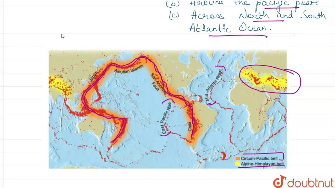
TLDRThe video explores the causes and impacts of earthquakes, focusing on their occurrence in three major regions: the mid-Atlantic ridge, the Alpide belt, and the circum-Pacific belt. It explains how tectonic plate movements generate immense pressure, leading to sudden energy releases that cause ground vibrations. Using seismographs, the intensity of earthquakes is measured, with the moment magnitude scale being the most effective method. The video highlights the devastating effects of the 1960 Valdivia earthquake and discusses adaptive strategies in communities, such as earthquake-resistant structures and public safety education, showcasing the dual nature of earthquakes as both destructive and essential geological forces.
Takeaways
- 🌍 Earthquakes are primarily caused by the movement of tectonic plates beneath the Earth's crust.
- 🌊 Most seismic activity occurs in three key regions: the mid-Atlantic ridge, the Alpide belt, and the circum-Pacific belt.
- ⚡ About 80% of all earthquakes happen along the circum-Pacific belt, where many tectonic plates converge.
- 🔄 Tectonic plates constantly move, but can catch and stick at their edges, building up pressure.
- 💥 When the built-up pressure is released, it results in a sudden slip of the plates, causing an earthquake.
- 📉 Seismographs record seismic activity, capturing the intensity of ground vibrations as jagged lines.
- 📏 The moment magnitude scale is the preferred method for measuring earthquake strength, as it can assess quakes globally without an upper limit.
- 🇨🇱 The largest recorded earthquake was the Valdivia earthquake in Chile in 1960, measuring 9.5 in magnitude and generating a deadly tsunami.
- 🏗️ Communities in earthquake-prone areas have adapted by designing buildings that can sway instead of break during quakes.
- 🔔 Public education and drills are vital for preparing communities to respond effectively during seismic events.
Q & A
What are the main regions where most earthquakes occur?
-Most earthquakes occur in three main regions: the mid-Atlantic ridge, the Alpide belt, and the circum-Pacific belt, with approximately 80% of all earthquakes happening along the circum-Pacific belt.
What causes earthquakes?
-Earthquakes are caused primarily by pressure from the movement of tectonic plates, which can become stuck and accumulate stress until they suddenly slip, releasing energy.
What role do tectonic plates play in seismic activity?
-Tectonic plates constantly move and interact at their edges, causing stress that can lead to earthquakes when the plates catch and then slip.
How is the strength of an earthquake measured?
-The strength of an earthquake is measured using seismographs, which record the ground's movement and are primarily analyzed using the moment magnitude scale, which measures seismic energy logarithmically.
What is the moment magnitude scale?
-The moment magnitude scale is a logarithmic scale used to measure the magnitude of earthquakes, allowing for measurements of very large quakes and having no upper limit.
What was the largest recorded earthquake, and where did it occur?
-The largest recorded earthquake occurred near Valdivia, Chile, in 1960, measuring approximately 9.5 on the moment magnitude scale.
What effects did the Valdivia earthquake have beyond its immediate area?
-The Valdivia earthquake generated a massive tsunami that reached heights of up to 80 feet, impacting countries across the Pacific Ocean, including the Philippines and Japan.
How do some regions adapt to living in earthquake-prone areas?
-Regions prone to earthquakes often design buildings and bridges to sway rather than break, educate the public on safety measures during quakes, and conduct drills to ensure community preparedness.
What are the benefits of the seismic forces that cause earthquakes?
-While earthquakes can cause devastation, the same geological forces also create unique landforms and features on the planet, contributing to its character.
What is a seismograph, and how does it work?
-A seismograph is an instrument that records the movements of the ground during an earthquake, producing a jagged line that reflects the intensity and duration of the seismic activity.
Outlines

このセクションは有料ユーザー限定です。 アクセスするには、アップグレードをお願いします。
今すぐアップグレードMindmap

このセクションは有料ユーザー限定です。 アクセスするには、アップグレードをお願いします。
今すぐアップグレードKeywords

このセクションは有料ユーザー限定です。 アクセスするには、アップグレードをお願いします。
今すぐアップグレードHighlights

このセクションは有料ユーザー限定です。 アクセスするには、アップグレードをお願いします。
今すぐアップグレードTranscripts

このセクションは有料ユーザー限定です。 アクセスするには、アップグレードをお願いします。
今すぐアップグレード関連動画をさらに表示

Locations of Volcanoes

SIRKUM PASIFIK DAN SIRKUM MEDITERANIA

Persebaran Bencana Di Indonesia #kumer Geografi klas XI.

MECHANISM OF PLATE TECTONICS: CONVECTION CURRENT, SLAB PULL & RIDGE PUSH | SCIENCE 10 - Week 7

Grade 10 SCIENCE | Quarter 1 Module 6 | Divergent and Transform Fault Boundaries

DISTRIBUTION OF EARTHQUAKE AND VOLCANOES
5.0 / 5 (0 votes)
