Geo XI. 39. Persebaran Wilayah Rawan Bencana.
Summary
TLDRThis video explains the key factors contributing to Indonesia's vulnerability to natural disasters, including its position on the Pacific Ring of Fire, tropical climate, and tectonic plate boundaries. It highlights the risks of earthquakes, tsunamis, volcanic eruptions, floods, landslides, and cyclones, emphasizing the areas most prone to each type of disaster. The video provides a comprehensive overview of Indonesia's geographic and environmental challenges, offering insight into the region's disaster management needs.
Takeaways
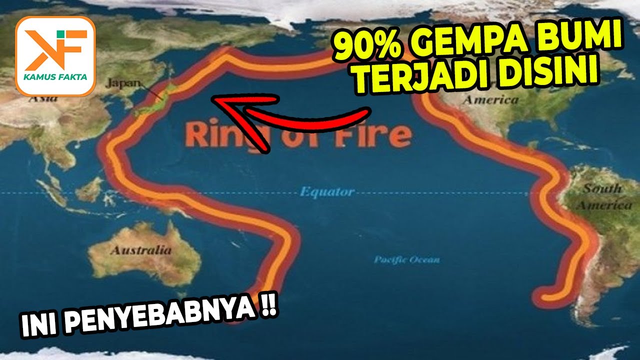
- 😀 Indonesia is highly vulnerable to natural disasters due to its location on the Pacific Ring of Fire, an area prone to frequent seismic activity.
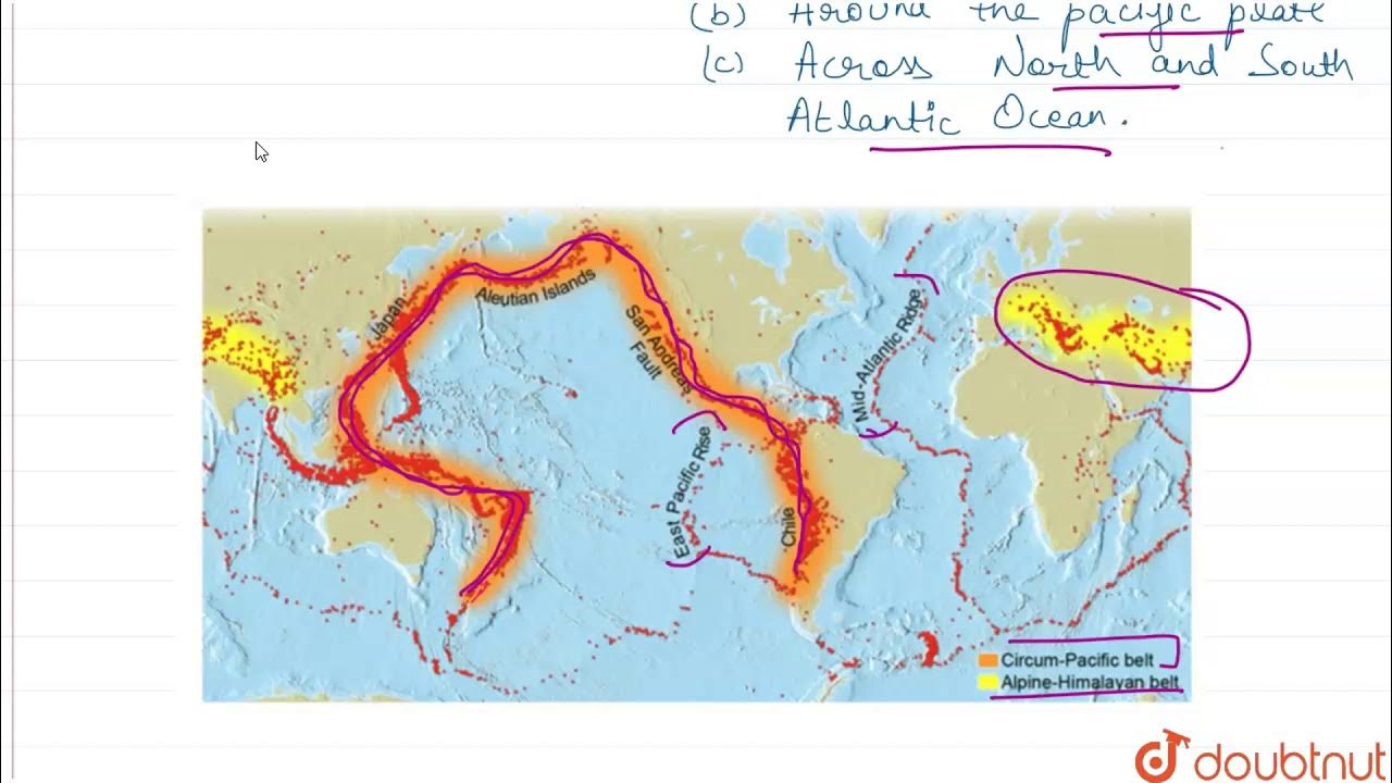
- 😀 The Pacific Ring of Fire extends from the Andes Mountains in South America to New Zealand, covering a vast area that includes Indonesia.
- 😀 Indonesia's tropical climate contributes to the high potential for hydrometeorological disasters, such as floods, landslides, and tropical cyclones.
- 😀 Indonesia's position at the intersection of three tectonic plates—Eurasian, Indo-Australian, and Pacific—makes it prone to earthquakes, tsunamis, and volcanic eruptions.
- 😀 Indonesia lies along the world's major mountain belts, including the Mediterranean Belt and Pacific Belt, which also contribute to the country's earthquake and volcanic activity.
- 😀 Sumatra, especially its west coast, is a major hotspot for earthquake activity in Indonesia, with frequent seismic events occurring in this region.
- 😀 Other regions prone to earthquakes include the southern coast of Java, Bali, Maluku, Sulawesi, and parts of Papua, though Kalimantan remains relatively safe from earthquakes.
- 😀 Tsunami risk in Indonesia is heightened in regions like Sumatra's west coast, as well as parts of Java, Sulawesi, and Papua, where tectonic plate movement often triggers tsunami waves.
- 😀 Indonesia has a significant number of active volcanoes, particularly in Sumatra, Java, and Bali, due to its geological location along major fault lines and mountain ranges.
- 😀 Flooding, landslides, and droughts are also frequent in various parts of Indonesia, including Sumatra, Java, Kalimantan, and Nusa Tenggara, with deforestation and climate change exacerbating the risks.
- 😀 Indonesia regularly experiences tropical cyclones, especially in the southern part of the country, with recent storms like Cyclone Seroja causing significant damage and loss of life.
Q & A
What are the main factors that make Indonesia prone to natural disasters?
-There are five main factors: Indonesia is located along the Pacific Ring of Fire, it has a tropical climate, it is situated at the intersection of three tectonic plates, it is prone to high levels of rainfall and hydrometeorological events, and it lies on major mountain ranges.
What is the Pacific Ring of Fire and how does it affect Indonesia?
-The Pacific Ring of Fire is a zone of frequent earthquakes and volcanic activity caused by the movement of tectonic plates. Indonesia is a significant part of this zone, which makes it vulnerable to earthquakes, tsunamis, and volcanic eruptions.
How does Indonesia’s tropical climate contribute to its vulnerability to natural disasters?
-Indonesia’s tropical climate leads to high levels of rainfall and evaporation, which in turn increases the risk of hydrometeorological disasters like floods, landslides, and tropical storms.
What tectonic plates are involved in the frequent natural disasters in Indonesia?
-Indonesia is located at the intersection of the Eurasian Plate, the Indo-Australian Plate, and the Pacific Plate. The movement of these plates causes earthquakes, volcanic eruptions, and tsunamis.
Which regions in Indonesia are most prone to earthquakes?
-The most earthquake-prone areas in Indonesia include Sumatra, especially along the west coast; Java, particularly the southern coast; the Maluku Islands; and parts of Sulawesi, except for some isolated regions.
Where are the tsunami-prone areas in Indonesia?
-Tsunamis in Indonesia are most likely to occur along the western coasts of Sumatra, the southern coasts of Java, and areas around Sulawesi and Papua, due to their proximity to tectonic plate boundaries and oceanic faults.
Which areas in Indonesia are at the highest risk of volcanic eruptions?
-Indonesia, as one of the countries with the highest number of active volcanoes, faces a high risk in areas like Sumatra, Java, Bali, and parts of Nusa Tenggara, where volcanic activity is frequent.
What regions in Indonesia are most vulnerable to landslides?
-Regions most vulnerable to landslides include Sumatra (particularly the Bukit Barisan mountain range), Java, Bali, and parts of Kalimantan, especially in areas with steep slopes and heavy rainfall.
How does deforestation and climate change affect Indonesia's risk of flooding?
-Deforestation and climate change contribute to increased flooding in Indonesia by reducing the capacity of natural landscapes to absorb rainfall, causing higher runoff and more severe flooding in areas with poor infrastructure.
What are the common impacts of tropical cyclones in Indonesia?
-Tropical cyclones, such as Typhoon Cempaka and Cyclone Seroja, lead to heavy rainfall, strong winds, flooding, and extensive damage to infrastructure, homes, and crops, especially in eastern Indonesia.
Outlines

Cette section est réservée aux utilisateurs payants. Améliorez votre compte pour accéder à cette section.
Améliorer maintenantMindmap

Cette section est réservée aux utilisateurs payants. Améliorez votre compte pour accéder à cette section.
Améliorer maintenantKeywords

Cette section est réservée aux utilisateurs payants. Améliorez votre compte pour accéder à cette section.
Améliorer maintenantHighlights

Cette section est réservée aux utilisateurs payants. Améliorez votre compte pour accéder à cette section.
Améliorer maintenantTranscripts

Cette section est réservée aux utilisateurs payants. Améliorez votre compte pour accéder à cette section.
Améliorer maintenantVoir Plus de Vidéos Connexes
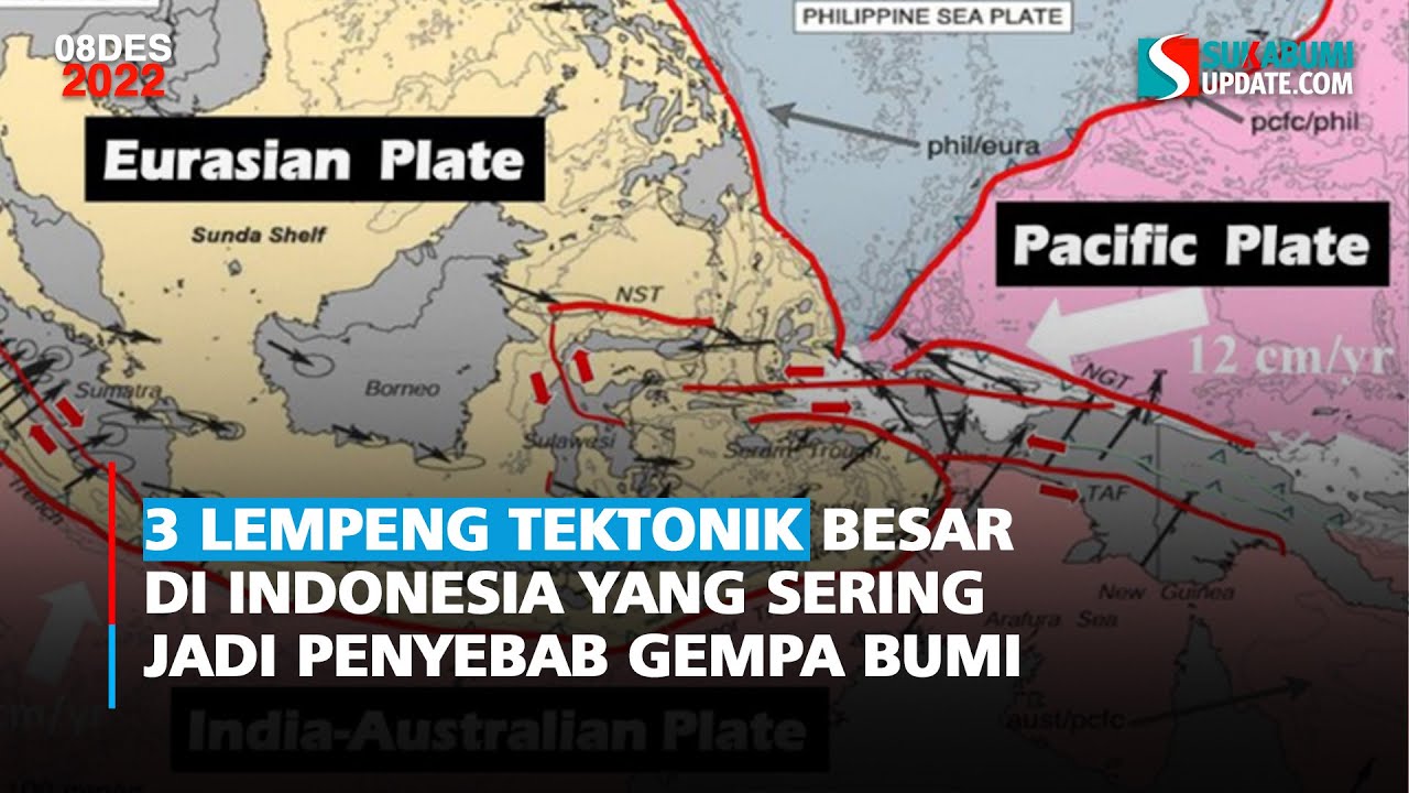
3 Lempeng Tektonik Besar di Indonesia yang Sering Jadi Penyebab Gempa Bumi
DISTRIBUTION OF EARTHQUAKE AND VOLCANOES
Persebaran Bencana Di Indonesia #kumer Geografi klas XI.

TERBENTUKNYA KEPULAUAN INDONESIA (SEJARAH INDONESIA)
RING OF FIRE | Fakta Fenomena Ring Of Fire Di Indonesia

Science 10: Lesson 1 Distribution of Earthquakes, Volcanoes, and Mountain Ranges
5.0 / 5 (0 votes)
