Bago mag-weekend, isang bagong bagyo ang posibleng pumasok sa PAR | Balitanghali
Summary
TLDRA new tropical storm is forecasted to enter the Philippine area of responsibility this weekend, potentially strengthening into a severe tropical storm. Named 'Ferdy,' it's expected to bring heavy to intense rains, causing flooding and landslides, particularly in Cagayan Valley, Aurora, Quezon, Bicol, Eastern Visayas, and Caraga Region. Metro Manila and other parts of the country may also experience widespread rain. Authorities advise the public to prepare for the possible adverse weather conditions over the weekend.
Takeaways
- ⏰ A new typhoon is expected to enter the Philippine area of responsibility over the weekend.
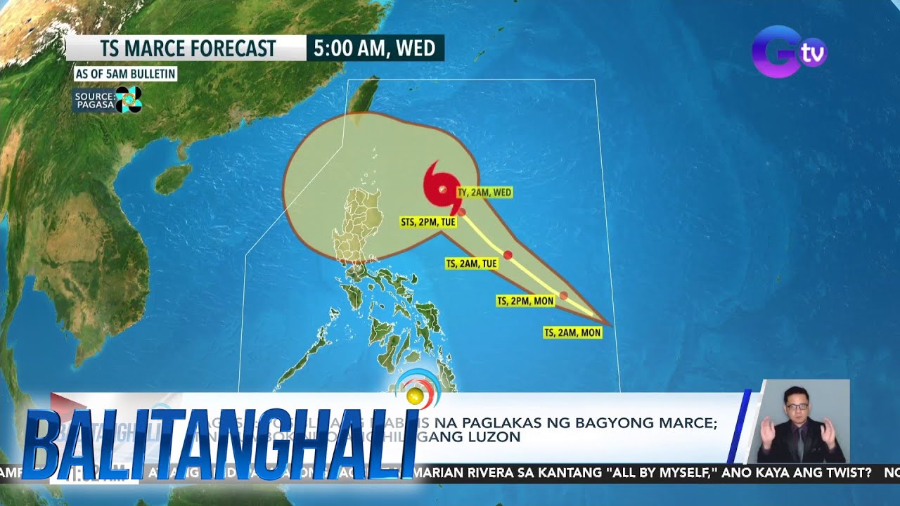
- 🌀 The tropical storm is named 'Ferdy' and is currently located 2070 km southwest of Eastern Visayas.
- 💨 It has wind speeds of up to 75 km per hour and may intensify into a severe tropical storm.
- 📅 The typhoon could enter the Philippine archipelago on Friday evening.
- 🌍 There will be no direct effect on the country, as the typhoon is expected to pass over China.
- 🌧️ Be prepared for a wet weekend due to the southwest monsoon enhanced by the typhoon.
- 🌊 The Cagayan Valley, Aurora, Quezon, Bicol, Eastern Visayas, and Caraga regions will experience scattered rain.
- 🌧️ The rest of the country, including Metro Manila, will have widespread rain in the coming hours.
- 🔍 Heavy to intense rains are possible, which may cause flooding or landslides based on the rainfall forecast from the weather agency.
Q & A
What is the expected weather condition for the weekend according to the script?
-A new typhoon is expected to enter the Philippine area of responsibility, potentially bringing heavy to intense rains and possible landslides.
What is the international name given to the tropical storm mentioned in the script?
-The international name given to the tropical storm is not explicitly mentioned in the script, but it is referred to as 'Ferdy' once it enters the Philippine area of responsibility.
How far is the tropical storm from the Eastern Visayas as per the script?
-The tropical storm is 2070 km southwest of Eastern Visayas.
What is the current wind strength of the tropical storm?
-The current wind strength of the tropical storm is 75 km per hour.
Is the tropical storm expected to directly affect the Philippines?
-The tropical storm is not expected to directly affect the Philippines, but it will bring a trough that will cause rain in certain regions.
Which areas are expected to be affected by the trough of the tropical storm?
-The Cagayan Valley region, Aurora, Quezon, Bicol, Eastern Visayas, and Caraga Region are expected to be affected by the trough of the tropical storm.
What type of rainfall is expected in the affected areas?
-The affected areas can expect heavy to intense rains, which may lead to flooding or landslides.
Is Metro Manila expected to experience rainfall due to the tropical storm?
-Yes, Metro Manila is expected to have rainfall due to the tropical storm.
What is the potential impact of the tropical storm on the weekend weather?
-The tropical storm may cause a hanging habagat (southwest monsoon) that will enhance the rain in the affected areas, leading to a wet weekend.
What is the advice given to the public regarding the approaching tropical storm?
-The public is advised to prepare for a possible wet weekend due to the enhanced southwest monsoon brought by the tropical storm.
Outlines

Dieser Bereich ist nur für Premium-Benutzer verfügbar. Bitte führen Sie ein Upgrade durch, um auf diesen Abschnitt zuzugreifen.
Upgrade durchführenMindmap

Dieser Bereich ist nur für Premium-Benutzer verfügbar. Bitte führen Sie ein Upgrade durch, um auf diesen Abschnitt zuzugreifen.
Upgrade durchführenKeywords

Dieser Bereich ist nur für Premium-Benutzer verfügbar. Bitte führen Sie ein Upgrade durch, um auf diesen Abschnitt zuzugreifen.
Upgrade durchführenHighlights

Dieser Bereich ist nur für Premium-Benutzer verfügbar. Bitte führen Sie ein Upgrade durch, um auf diesen Abschnitt zuzugreifen.
Upgrade durchführenTranscripts

Dieser Bereich ist nur für Premium-Benutzer verfügbar. Bitte führen Sie ein Upgrade durch, um auf diesen Abschnitt zuzugreifen.
Upgrade durchführenWeitere ähnliche Videos ansehen

Bagyong may international name na “Bebinca,” patuloy na lumalakas...| Unang Balita

PAGASA: ‘Bebinca’-enhanced ‘habagat’ rains to last 3–4 days

Bagyong Nika, lalong lumakas at naging tropical storm na | 24 Oras Weekend

Storm trough, ‘habagat’ to bring rains across parts of the Philippines
PAGASA - Posible ang mabilis na paglakas ng Bagyong Marce; tinutumbok nito ang... | Balitanghali

Signal no. 2 up over 2 Luzon areas as Tropical Storm Enteng strengthens | INQToday
5.0 / 5 (0 votes)
