Inilah asal-usul Lempeng Tektonik, dan iniah alasan Indonesia sering terjadi Gempa Bumi?
Summary
TLDRIndonesia, situated in the Ring of Fire, experiences frequent seismic and volcanic activities due to its location at the intersection of four tectonic plates: the Indo-Australian, Eurasian, Pacific, and Philippine Sea plates. These plates, formed by the movement of the Earth's lithosphere, are responsible for the creation of geological features like the Himalayas and the East African Rift. The interaction of these plates not only causes natural disasters but also shapes Indonesia's diverse and complex landscape, making it the world's largest archipelago with unique geological formations.
Takeaways
- 🌋 Indonesia is situated in the Ring of Fire, an area around the Pacific Ocean known for frequent seismic and volcanic activities.
- 🌏 The Ring of Fire forms a large circle around the Pacific Ocean due to the meeting of tectonic plates.
- 🔍 The movement of tectonic plates can cause natural disasters such as earthquakes, volcanic eruptions, and tsunamis.
- 🌐 The Earth's lithosphere, consisting of the crust and the upper mantle, is divided into tectonic plates that move due to asthenosphere convection.
- 📚 The theory of plate tectonics, developed from the 1950s to 1970s, updated the earlier concept of continental drift proposed by Alfred Wegener in 1912.
- 🏔 The Himalayan mountains and the East African Rift are examples of geological formations caused by tectonic plate interactions.
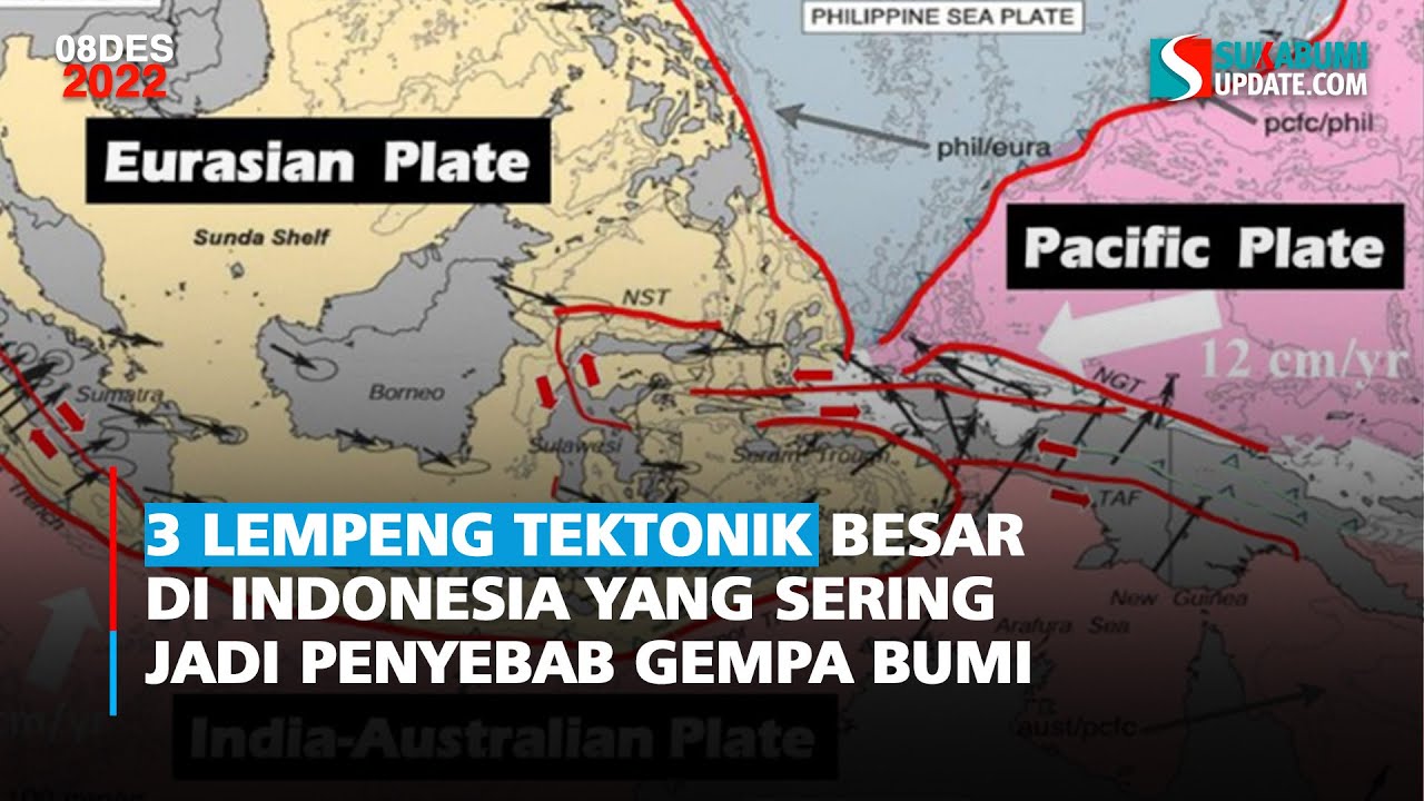
- 🌳 Indonesia is surrounded by four major tectonic plates: Indo-Australian, Eurasian, Pacific, and Philippine Sea plates.
- 🌊 The Indo-Australian plate, formed by the fusion of the Australian and Indian plates, is located in eastern Indonesia.
- 🌍 The Eurasian plate, the third largest, encompasses most of Europe and Asia and is geologically very active, affecting areas like Indonesia.
- 🏞️ The Pacific plate, the largest, is primarily under the Pacific Ocean and influences the formation of islands like Hawaii.
- 🌿 The Philippine Sea Plate is a smaller micro plate in northern Indonesia, interacting with the other three major plates.
Q & A
What is the Ring of Fire?
-The Ring of Fire is a group of areas around the Pacific Ocean that frequently experience earthquakes and volcanic eruptions, forming a large circle or ring that encircles the Pacific Ocean.
Why is the Ring of Fire prone to seismic and volcanic activity?
-The Ring of Fire is located at the meeting of tectonic plates which move together along this ring, causing earthquakes, volcanic eruptions, and even tsunamis when these plates interact.
What is the significance of tectonic plates in the formation of continents and oceans?
-Tectonic plates are the background for the formation of various continents and oceans as we know them today, as their movement and interaction have shaped the Earth's surface over geological time.
What is the lithosphere and how is it related to tectonic plates?
-The lithosphere is the Earth's rigid outer layer, consisting of the crust and the top part of the mantle, which is divided into tectonic plates that move relative to each other.
How do tectonic plates move and what causes their movement?
-Tectonic plates move due to convection in the asthenosphere, which is solid but can flow like a liquid over very long geological timescales, causing the plates to move at different speeds.
What is the theory of plate tectonics and how was it developed?
-The theory of plate tectonics explains the movement of the Earth's lithosphere and was developed from the 1950s to the 1970s, updating the earlier idea of continental drift.
How does the theory of plate tectonics relate to the formation of the Himalayan mountains?
-The Himalayan mountains were formed due to the collision of the Eurasian plate and the Indo-Australian plate, which is an example of how tectonic plate interactions can create geological formations.
Which tectonic plates surround Indonesia?
-Indonesia is surrounded by four tectonic plates: the Indo-Australian plate, the Eurasian plate, the Pacific plate, and the Philippine Sea Plate.
What is the size and significance of the Indo-Australian plate?
-The Indo-Australian plate has an area of approximately 58.9 million km² and was formed from the fusion of the Australian plate and the Indian plate. It is significant for its role in the formation of the Himalayan mountains.
How does the movement of the Pacific plate affect the geological activity in Indonesia?
-The Pacific plate, being the largest plate and located under the Pacific Ocean, influences the geological activity in Indonesia, especially along the areas where it interacts with other plates, contributing to the formation of volcanoes and the Ring of Fire.
Why is Indonesia prone to earthquakes and volcanic activity?
-Indonesia is prone to earthquakes and volcanic activity due to its location at the convergence of four tectonic plates, which cause significant geological movements and interactions.
Outlines
🌋 Understanding the Ring of Fire and Tectonic Plates
The script discusses Indonesia's geographical location within the Ring of Fire, an area around the Pacific Ocean known for frequent seismic and volcanic activities. The term 'Ring of Fire' is derived from the circular pattern these areas form around the ocean. The region's high tectonic activity is attributed to the interaction of tectonic plates. The script introduces the theory of plate tectonics, explaining the Earth's lithosphere and asthenosphere, and how the movement of tectonic plates on the asthenosphere leads to geological formations and natural disasters. It also touches on the historical development of plate tectonics theory, from Alfred Wegener's continental drift hypothesis to its acceptance following the validation of seafloor spreading.
🌍 Tectonic Plates Surrounding Indonesia
The second paragraph delves into the specific tectonic plates surrounding Indonesia and their characteristics. It identifies four major plates: the Indo-Australian Plate, formed by the fusion of the Australian and Indian plates, which is responsible for the formation of the Himalayas; the Eurasian Plate, the world's third-largest plate encompassing most of Europe and Asia and known for its geological activity; the Pacific Plate, the largest plate that underlies the Pacific Ocean and influences areas like California and New Zealand; and the Philippine Sea Plate, a smaller micro plate in comparison. The paragraph also discusses the movements of these plates and their impacts on the geological features of Indonesia, such as the formation of the Hawaiian Islands and the Ring of Fire.
🏞️ Indonesia's Unique Geological Landscape
The final paragraph focuses on the unique geological landscape of Indonesia, shaped by the movements of the tectonic plates. It highlights how the interaction of these plates results in a complex and diverse topography, including beaches, sea trenches, active mountains, and faults. The paragraph emphasizes the ongoing impact of plate movements, which not only create a rich variety of geological features but also make Indonesia prone to earthquakes and volcanic eruptions. The script concludes by summarizing the importance of understanding these tectonic activities for the safety and awareness of local communities.
Mindmap
Keywords
💡Ring of Fire
💡Tectonic Plates
💡Lithosphere
💡Asthenosphere
💡Plate Tectonics
💡Continental Drift
💡Pangea
💡Indo-Australian Plate
💡Eurasian Plate
💡Pacific Plate
💡Philippine Sea Plate
Highlights
Indonesia is located in the Ring of Fire, an area with frequent seismic and volcanic activity.
The Ring of Fire forms a large circle around the Pacific Ocean where tectonic plates meet.
Tectonic plate interactions can cause natural disasters like earthquakes and tsunamis.
Tectonic plates are responsible for the formation of continents and oceans.
The Earth's lithosphere is a rigid outer layer consisting of the crust and the upper mantle.
The asthenosphere is solid but flows very slowly over geological timescales.
There are 7 main tectonic plates on Earth, which move due to asthenosphere convection.
The theory of plate tectonics updated the earlier concept of continental drift.
Alfred Wegener proposed the idea of continental drift in 1912.
The continents were once a single unit known as Pangea.
Tectonic plates are likened to floating ice, moving over the Earth's surface.
Indonesia is surrounded by four tectonic plates.
The Indo-Australian plate was formed from the fusion of the Australian and Indian plates.
The Eurasian plate is the third largest and includes most of Europe and Asia.
The Pacific plate is the largest and is primarily under the Pacific Ocean.
The Philippine Sea Plate is a micro marine plate located in the northern region of Indonesia.
Each plate in Indonesia moves differently, influencing the geological activity.
Indonesia's complex geological activity results in a unique and diverse landscape.
Indonesia's location in the Ring of Fire makes it prone to tectonic earthquakes.
Transcripts
In several previous videos,
we mentioned that our country, Indonesia,
is geographically located in an area
known as the Ring of Fire.
The Ring of Fire
is a group of areas around the Pacific Ocean
which frequently experience earthquakes
and volcanic eruptions.
This area is called the Ring. fire
because this area
forms a
large circle or ring that encircles the Pacific Ocean.
This area
has a lot of seismic and volcanic activity
because it is located
at
the meeting of tectonic plates which move together
along this ring
. The earth's plates meet
, move and collide with each other.
The negative effect is
when the plates these interact,
they can cause natural disasters
such as earthquakes,
volcanic eruptions
and even tsunamis,
however,
these plates
are the background for the formation of various continents
and oceans
as we
know
them today
.
the place where 4
tectonic plates meet
, three of which are the
main plates
. Before discussing further,
it would be good if we first know
what tectonic plates are.
If we talk about tectonic plates
, it cannot be separated from the theory of
plate tectonics or the formation of the earth
, where the earth was formed due to
movement. below the earth's surface
according to this theory
the earth has a rigid outer layer
called the lithosphere
which consists of the crust and the top part of the earth's mantle
whose contents are stiff and solid
which usually has a thickness of about 100 km
below the lithosphere layer
there is an asthenosphere which is solid
but can flow like a liquid
very slowly
and over a very long geological time scale
because of the low
viscosity and shear strength.
The deeper
part of the mantle below the asthenosphere
becomes stiffer,
the cause is not colder temperatures
but high pressure.
The lithosphere layer
is divided into tectonic plates
on earth there are 7 main plates
and many smaller plates
these lithospheric plates ride on
the asthenosphere
due to convection asthenosphere and lithosphere
these plates
move relative to each other
at different speeds
from 2-15 centimeters per year
the interaction of tectonic plates
is responsible for various geological formations
such as the Himalayan mountains in Asia,
the East African gap
and the San Andreas fault in California, the United States.
The theory of plate tectonics itself
was developed from the 1950s
to the 1970s.
The theory
of plate tectonics is a modern update to
Continental drift,
an idea first proposed
by scientist Alfred Wegener in 1912,
stated that the
Earth's continents had drifted
across the planet
over time.
This theory began to be accepted by geoscientists
after seafloor spreading was validated
in the mid to late 1960s.
Tectonics is used to explain
continental drift,
a phenomenon that occurred when
the continents were still a single unit
, called a super-large continent or supercontinent
or called Pangea
, until not long after that
the continent that emerged was divided into several parts.
Some parts of this divided continent
were called Gondwana and Laurasia
. some of these continents are characterized by movement
and are likened to floating pieces of ice
and move in
the ocean because this is
the theory of tectonic plates, also called the theory of
continental drift.
Based on the explanation of this theory,
it can be said
that tectonic plates are the uppermost part of the earth
with phenomena that arise as a result of the movement process
and influence the height and low of the earth
directly.
This movement process
makes a significant influence on the
geologically
dynamic appearance of the earth's surface.
Indonesia itself is surrounded by 4 tectonic plates
.
What tectonic plates surround Indonesia
? Quoted from gramedia.com,
here are the 4 tectonic plates that surround Indonesia.
The Indo-
Australian plate. The Indo-Australian plate
has an area of approximately 58 .9 million km² then
the Indo Australian plate
was formed from the fusion of plates
between the Australian plate and the Indian plate
millions of years ago
and several years ago
or when the Eurasian plate
and the Indo Australian plate collided with each other
, the Himalayan mountains were formed.
Apart from that,
several researchers have researching the
Indo-Australian
plate believes that the Indian plate and the Australian plate
are two plates that separated from each other
several
millions of years ago.
In Indonesia,
the Indo-Australian plate
is located in eastern regions
such as Papua Island and also East Nusa Tenggara Island
, which are then connected to each other. with the Eurasian plate
to the west
and to the north there is the Pacific plate,
the Eurasian plate
, the next plate in Indonesia is the Eurasian plate,
this plate
is estimated to have an area of
approximately 67.8 million km²
because this plate is quite large
, this plate
is included in the plate. 3rd largest in the world
, in fact almost all areas of
the European and Asian continents are on this plate.
Apart from that, there are many
geological schemes that occur on the Eurasian plate
, even some of the geological schemes that occur are quite large
, one of which
is the formation of the Himalayan mountains
and also the formation of the Caspian Sea lake,
this lake has become the largest lake in the world
to date,
the Eurasian plate
can be said to be the most geologically active plate,
therefore
in the areas passed by this plate
volcanic events
and earthquakes usually occur
in the Indonesian
region . which this plate passes through
are large islands
such as Sumatra Island,
Java Island, Sulawesi Island
and Kalimantan Island
, therefore it
can be said that the Eurasian plate
is the base of Indonesia, currently
the Pacific plate
, the third plate that surrounds Indonesia ,
is the Pacific plate, this
Pacific plate.
It is estimated that it has an area of
approximately 103.3 million km²,
therefore
this plate is the largest plate
in the world today.
Apart from that,
this plate is located under the Pacific Ocean
starting from the northern part of Papua Island,
Indonesia
. In general,
the Pacific plate can be said to be crust from
the ocean, except in areas around California
and New Zealand,
even this plate
played quite a role in the formation of the Hawaiian Islands.
Initially,
the Hawaiian Islands were volcanoes that
were under the sea
, then pushed upwards
to form land that
existed millions of years ago.
then the formation of this volcano
occurs through several points on the Pacific plate
and then at each outer boundary of the plate
This Pacific Ocean
forms a ring of fire at the bottom of the Pacific Ocean
, where the ring
of fire
causes volcanoes in several areas
of the Philippine Sea Plate
. The 4th plate that surrounds Indonesia
is then the Philippine Sea Plate.
If the previous three plates
are included in the macro category
, then the Philippine Sea Plate
This is a micro marine plate,
this is because this plate has an area of
approximately 5.5 million km²,
the Philippine Sea Plate
is located in the northern region of Halmahera Waigeo Island,
Papua Island
, apart from that, it is also
located in the outermost part of the Sangihe Talaud Islands,
this Philippine Sea Plate
is in direct contact
with three macro plates
in Indonesia
, namely the Eurasian plate,
the Indo-Australian plate
and the Pacific plate,
each plate
in Indonesia
has different movements,
such as the Indo-Australian plate which
moves to the northeast
at a speed of 7.7 cm
per year,
the Pacific plate is moving to the northwest
at a speed of 10.2 cm per year,
meanwhile
the Eurasian plate is relatively stationary
in Indonesia itself . Collision
movements
can cause volcanoes
starting from the northern tip of Sumatra Island
to Java Island
, Bali Island, East Nusa Tenggara.
continues until it heads east, turning towards Maluku.
Therefore, there
is evidence that
the impact movement is still ongoing.
As
a result of this movement
, in Indonesia , tectonic
earthquakes often occur
which can then be dangerous for the surrounding community.
The impact
also makes Indonesia a
country. with the largest archipelago in the world
which is very complex and unique,
therefore
we often
encounter various forms of beaches,
sea trenches ,
active mountains
and faults, making them prone to tectonic earthquakes
. That's a video about the tectonic plates
that surround Indonesia
. Hopefully
this video can add a little insight
and knowledge to Thank
you all for watching
and wait for our next video
浏览更多相关视频
Letak Geologis Indonesia
PLATE TECTONIC THEORY | Volcanoes, Earthquakes, Mountain Ranges| Grade 10 Science Quarter 1 Module 1
Tectonic Plates and Earthquakes | Motion Graphics | Pixeldust Studios
Science 10: Lesson 1 Distribution of Earthquakes, Volcanoes, and Mountain Ranges
How the Philippine Island Arc was Formed | Dr. Carla Dimalanta
Japan—Earthquakes & Tectonics (Educational)
5.0 / 5 (0 votes)