GEOGRAFÍA BÁSICA DE ÁFRICA EN 7 MINUTOS
Summary
TLDRThe video offers an engaging exploration of Africa, highlighting its diverse geography and contrasts. It begins by discussing the continent's unique shape, with coastlines along both the Atlantic and Indian Oceans, as well as notable islands. The script delves into key geographic features like the Sahara Desert, the Rift Valley, and the highlands of Eastern Africa, including Mount Kilimanjaro. The video also touches on the Congo Basin, desert regions, and the varied ecosystems across Africa, presenting the continent as a land of remarkable contrasts, rich in history, natural beauty, and diverse landscapes.
Takeaways
- 😀 Africa is a continent of contrasts, ranging from vast deserts like the Sahara to deep jungles.
- 😀 Geographically, Africa is located south of Europe, north of Antarctica and the Antarctic Ocean, east of the Americas, and west of Asia.
- 😀 Africa's coastlines are not very indented, and the continent has a distinctive shape, with a bulging west coast and a narrow eastern coastline.
- 😀 The Atlantic Ocean coastline includes the Gulf of Guinea, while the eastern coast is shaped by the Somalia Peninsula and the Indian Ocean.
- 😀 Key islands around Africa include Madagascar, along with smaller islands in the Indian and Atlantic Oceans like Seychelles, Mauritius, Reunion, Canary Islands, and Azores.
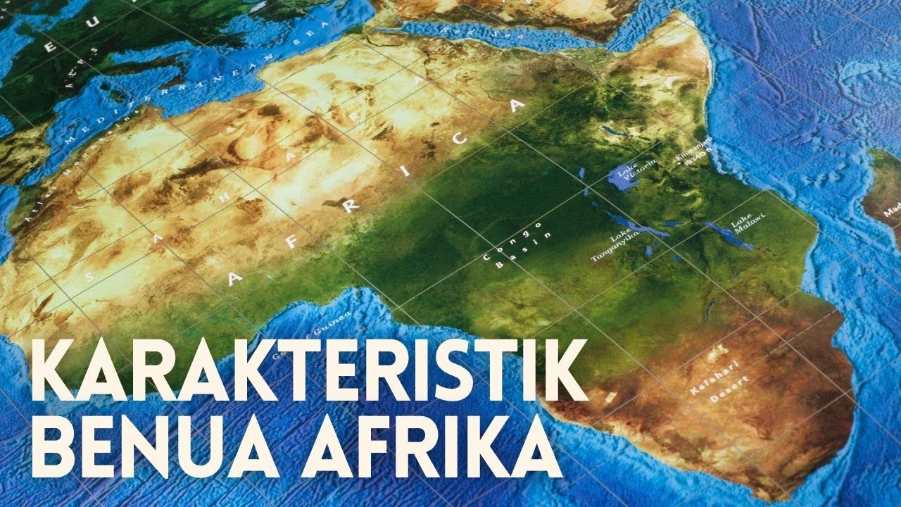
- 😀 The Sahara Desert, the world's largest, covers much of northern Africa and is bordered by the Atlas Mountains to the north and the Nile River to the east.
- 😀 The Nile River is historically significant, providing the foundation for ancient civilizations like Egypt.
- 😀 The Rift Valley, the largest tectonic rift in the world, spans 4,000 kilometers and is considered the origin of humanity with the oldest known human fossils found here.
- 😀 Africa's highest peak is Mount Kilimanjaro, located in the eastern part of the continent, standing at 5,895 meters.
- 😀 The southern regions feature the deserts of Namibia and Kalahari, while the Drakensberg Mountains define the southernmost part, near the Cape of Good Hope.
- 😀 The Congo Basin in central Africa is known for its dense rainforest, which plays a crucial role in the region's biodiversity.
Q & A
What are the main geographical characteristics of Africa?
-Africa is a continent characterized by a variety of geographical features, including a vast and devastating desert (the Sahara), deep jungles, and extensive coastlines. It is bordered by the Atlantic Ocean to the west, the Indian Ocean to the east, and the Mediterranean Sea to the north.
What is the shape of Africa's coastline, and how does it affect the continent's geographical features?
-Africa's coastline has a somewhat peculiar shape. The western coast, along the Atlantic Ocean, forms a pronounced curve, while the eastern coast has a narrow extension that resembles a tail. The coastline is relatively smooth with few major indentations, and it features significant geographical landmarks like the Gulf of Guinea and the Somali Peninsula.
What is the significance of the Gulf of Guinea and the Somali Peninsula in Africa's geography?
-The Gulf of Guinea and the Somali Peninsula play important roles in defining Africa's shape. The Gulf of Guinea marks the western boundary, contributing to the curve of Africa's coastline, while the Somali Peninsula in the east forms a distinctive point, extending into the Indian Ocean.
What are the major islands surrounding Africa, and where are they located?
-Africa is surrounded by several islands, notably the large island of Madagascar, located off the southeastern coast. Smaller islands include those in the Indian Ocean, such as the Seychelles, Mauritius, and Réunion, and in the Atlantic Ocean, including the Canary Islands (part of Spain) and the Azores (part of Portugal).
What are the main features of Africa's relief, and how is it divided geographically?
-Africa's relief is divided into various regions, including the Northern Plateau (featuring the Sahara Desert), the Eastern Highlands (with the Great Rift Valley and Mount Kilimanjaro), and the Southern Plateau (with deserts like Namibia and Kalahari, and the Drakensberg Mountains). The Congo Basin is a significant geographical feature, marked by tropical rainforests.
What is the Sahara Desert, and what role does it play in Africa's geography?
-The Sahara Desert is the largest hot desert in the world, occupying a vast portion of northern Africa. It is an iconic and harsh landscape that has inspired many legends and adventures. It is bordered by the Atlas Mountains to the north and features significant geographical features like the Nile River to the east.
What are the main geographical features of the East African Highlands?
-The East African Highlands are characterized by the Great Rift Valley, the largest tectonic fault system in the world. This region is also known as the 'Cradle of Humankind,' as it is where some of the earliest human ancestors were found. The area is also home to Mount Kilimanjaro, Africa's highest peak.
What is the Great Rift Valley, and why is it significant?
-The Great Rift Valley is a massive tectonic feature that stretches for about 4,000 kilometers through eastern Africa. It is significant because it represents the Earth's largest fault system and is home to important archaeological sites, including the early development of human ancestors.
What is the Congo Basin, and what type of ecosystem is found there?
-The Congo Basin is a vast area of tropical rainforest located in central Africa. It is one of the world's largest rainforests and supports a unique ecosystem, home to a wide range of biodiversity, including various species of plants, animals, and birds.
How do Africa's various deserts and mountain ranges contribute to the continent's overall climate and biodiversity?
-Africa's deserts, like the Sahara, and mountain ranges, like the Drakensberg and Atlas Mountains, create diverse climate zones across the continent. The deserts result in dry, arid conditions, while the mountains contribute to cooler, temperate climates and often act as barriers for biodiversity. These geographical features create contrasting biomes, from arid deserts to lush rainforests and savannas.
Outlines

This section is available to paid users only. Please upgrade to access this part.
Upgrade NowMindmap

This section is available to paid users only. Please upgrade to access this part.
Upgrade NowKeywords

This section is available to paid users only. Please upgrade to access this part.
Upgrade NowHighlights

This section is available to paid users only. Please upgrade to access this part.
Upgrade NowTranscripts

This section is available to paid users only. Please upgrade to access this part.
Upgrade NowBrowse More Related Video

3ª Série - Geografia - Aula 08 - Análise da Diversidade Geográfica e Socioeconômica

Ada Berapa Banyak Negara di Benua Afrika?

30 Curiosidades que no Sabías sobre Hungría | Los asiáticos de Europa central.

Curitiba Kur Yt Yba - Uma aula sobre a cidade - natureza, história e atualidade por terra, ar e água

Honduras - All you need to know - Geography, History, Economy, Climate, People and Culture
Karakteristik dan Fakta Benua Afrika Terlengkap
5.0 / 5 (0 votes)