Bagyong Dante at Bagyong Emong, humahatak at pinalalakas ang Habagat; malaking bahagi... | 24 Oras
Summary
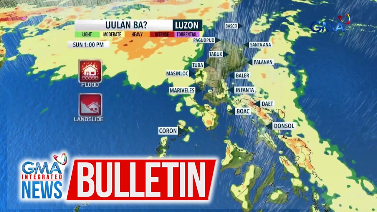
TLDRIn this weather update, Amor La Rosa from GMA Integrated News discusses the impact of two typhoons—Dante and Emong—on the Philippines. Typhoon Dante, moving towards the Ryukyu Islands, has winds of 65 km/h, while Typhoon Emong is affecting Northern Luzon with strong gusts and heavy rain. The Fujita effect, causing interaction between the two storms, is also highlighted. The forecast predicts continuous heavy rain, flash floods, and potential landslides across much of Luzon, as well as rain in Visayas and Mindanao. The weather conditions will remain challenging, with advisories in effect throughout the region.
Takeaways
- 🌪️ Two typhoons, Typhoon Dante and Typhoon Emong, are impacting the weather in the Philippines, with Typhoon Dante in the east and Typhoon Emong in the west.
- 🌀 Typhoon Dante is located 835 km east-northeast of Extreme Northern Luzon, with winds reaching 65 km/h and gusts up to 80 km/h.
- 📍 Typhoon Dante is expected to move northwest toward the Ryukyu Islands and East China Sea, possibly exiting the Philippine Area of Responsibility (PAR) by tomorrow afternoon or evening.
- 💨 Typhoon Emong is 150 km west of Lawag City and is moving southwesterly, with a speed of 20 km/h. It has triggered Signal No. 1 in several provinces.
- ⚠️ Gale warnings have been issued for the western seaboards of Northern Luzon, making it dangerous to venture out to sea.
- 🔄 The movement of Typhoon Emong will change due to the Fujiwara effect, which causes interaction with Typhoon Dante. This may lead to Typhoon Emong making landfall in Ilocos.
- 🌧️ Heavy rain, strong gusts, and flash flood risks are expected across large parts of the Philippines, particularly in Northern and Central Luzon, the Cordillera, and Metro Manila.
- 🚨 Torrential rain and possible landslides are a concern in areas such as Ilocos, Cordillera, Central Luzon, and Southern Luzon, especially during the afternoon and evening.
- 🌧️ The Visayas and Mindanao will also experience rain, particularly in Panay Island, Negros Island, and the Zamboanga Peninsula, continuing into the afternoon.
- 🌦️ Outside the PAR, there is severe weather, and although there is a high chance of it becoming a typhoon, it is expected to move northward and will likely not affect the Philippines.
Q & A
What are the two typhoons mentioned in the script?
-The two typhoons mentioned are Typhoon Dante and Typhoon Emong.
Where is Typhoon Dante currently located?
-Typhoon Dante is currently located 835 km east-northeast of Extreme Northern Luzon.
What is the wind speed and gust speed of Typhoon Dante?
-Typhoon Dante has a wind speed of 65 km/h and gusts reaching 80 km/h.
What is the expected movement of Typhoon Dante?
-Typhoon Dante is expected to move northwest towards the Ryuku Islands and the East China Sea, and it may exit the Philippine Area of Responsibility by tomorrow afternoon or evening.
Where is Typhoon Emong currently located?
-Typhoon Emong was last seen 150 km west of Lawag City in Ilocos Norte.
What is the wind direction and movement of Typhoon Emong?
-Typhoon Emong is moving southwesterly at a speed of 20 km/h, but its direction will change due to its interaction with Typhoon Dante.
What weather warnings have been issued because of Typhoon Emong?
-Signal number one has been raised in Ilocos Norte, Ilocos Sur, La Union, Northern and Western portions of Pangasinan, Apayao, Abra, and Benguet. There is also a gale warning for the Western Seaboards of Northern Luzon.
What is the Fujiwara effect mentioned in the script?
-The Fujiwara effect refers to the interaction between two typhoons. In this case, Typhoon Emong's movements are being influenced by Typhoon Dante.
What areas are expected to experience heavy rain due to the typhoons?
-Heavy rain is expected in the Ilocos region, the Cordillera, Northern and Central Luzon, Metro Manila, Calabarzon, Mindoro, Palawan, Bicol Region, and parts of the Visayas and Mindanao.
What should people do to stay safe during the typhoons?
-People should be cautious of flash floods and landslides due to the heavy rains, avoid venturing out to sea where gale warnings are in effect, and stay tuned for updates on the weather situation.
Outlines

This section is available to paid users only. Please upgrade to access this part.
Upgrade NowMindmap

This section is available to paid users only. Please upgrade to access this part.
Upgrade NowKeywords

This section is available to paid users only. Please upgrade to access this part.
Upgrade NowHighlights

This section is available to paid users only. Please upgrade to access this part.
Upgrade NowTranscripts

This section is available to paid users only. Please upgrade to access this part.
Upgrade NowBrowse More Related Video

Bagyong Gener at Bagyong tatawaging "Helen," posibleng magsabay sa loob ng PAR ngayong... | 24 Oras
Asahan pa rin ang mga pag-ulan sa bansa dulot ng... | GMA Integrated News Bulletin

Maraming motorista, hindi nakadaan dahil sa landslide sa Brgy. Talaguton | Unang Balita

PHL Gymnast Carlos Yulo, panalo ng 2 gintong medalya sa Vault at Floor Exercise sa...| Balitanghali

Pilipinas, may pinakamataas na world risk index, ayon sa isang pag-aaral | Unang Balita

Cloud cluster o kumpol ng mga ulap, namataan sa labas ng PAR - Weather update today...| Unang Balita
5.0 / 5 (0 votes)