How Do Scientists Utilize Marine Weather Station Data? - Weather Watchdog
Summary
TLDRMarine weather stations play a crucial role in tracking atmospheric and oceanic conditions, using sensors to measure wind speed, temperature, humidity, and pressure. This data aids in navigation, environmental monitoring, climate research, and weather forecasting. By integrating real-time and historical data, these stations enhance the accuracy of forecasts, benefiting industries like shipping and fishing. Companies, such as Sofar Ocean, use this data to optimize routes and reduce emissions. With advancements like AI models and satellite measurements, marine weather stations are essential for understanding and predicting weather patterns, supporting both practical applications and scientific research.
Takeaways
- 😀 Marine weather stations play a key role in tracking ocean conditions by gathering data on atmospheric and oceanic factors.
- 😀 The sensors in marine weather stations measure wind speed, air temperature, humidity, and barometric pressure.
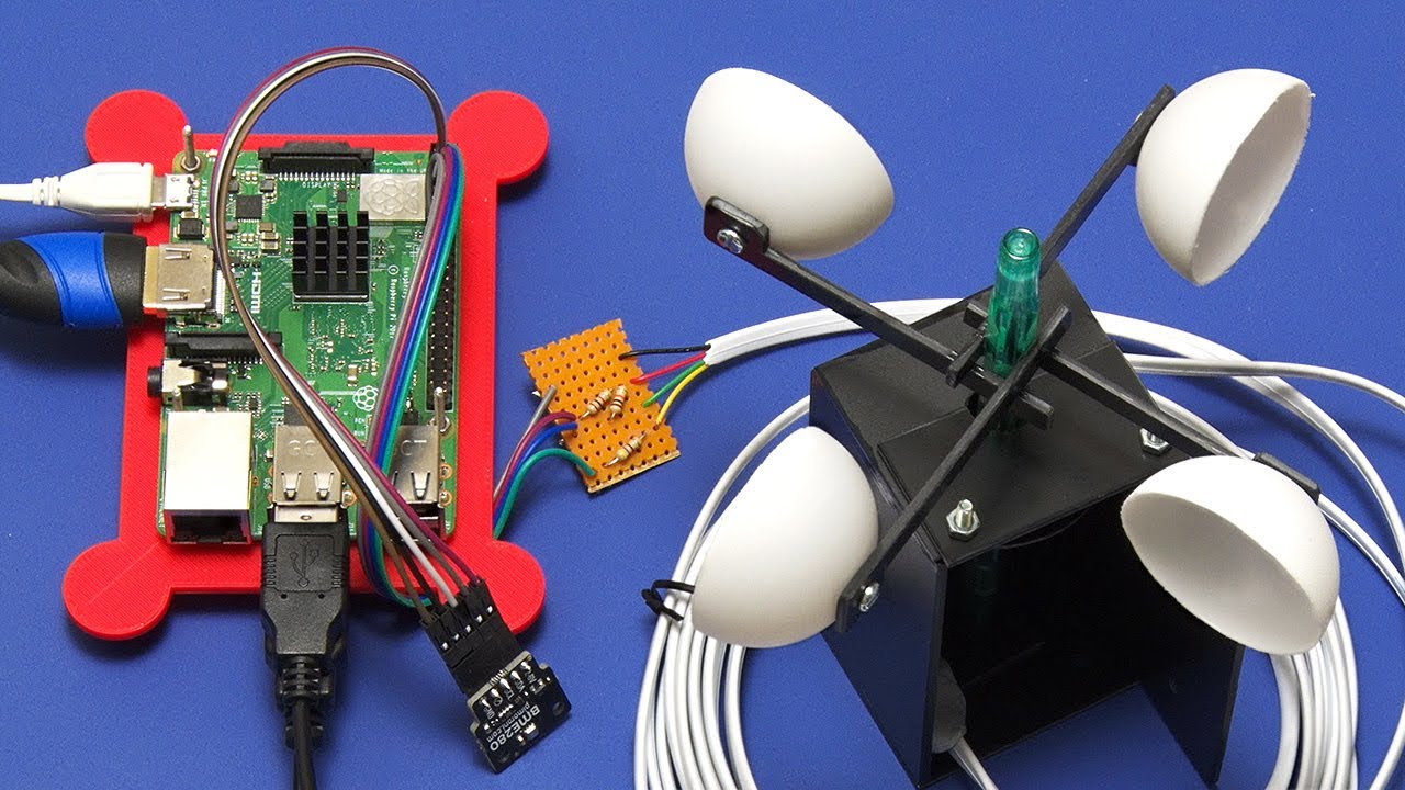
- 😀 These sensors (animometers, barometers, thermometers, and hydrometers) work together to provide a comprehensive view of marine environments.
- 😀 Real-time weather information from marine weather stations supports safe maritime navigation by helping sailors avoid dangerous conditions.
- 😀 Environmental monitoring uses marine station data to track climate change and assess the health of marine ecosystems.
- 😀 Scientists rely on marine weather data for research in oceanography, meteorology, and climate science.
- 😀 Data from marine weather stations improves weather forecasting, leading to better predictions of oceanic conditions like waves, winds, and currents.
- 😀 Companies like Sofar Ocean use real-time marine weather data to optimize shipping routes, reduce voyage times, and lower emissions.
- 😀 Long-term data from marine weather stations is essential for studying global climate patterns and ocean currents.
- 😀 Modern marine weather stations offer advanced data integration capabilities, enabling real-time monitoring and enhanced decision-making.
- 😀 Technological advancements, including AI-powered models and satellite measurements, improve the accuracy of weather predictions for maritime and oceanic conditions.
Q & A
How do marine weather stations collect data about ocean conditions?
-Marine weather stations collect data using various sensors that measure wind speed, direction, air temperature, humidity, and barometric pressure. These sensors are the key components that help track oceanic and atmospheric conditions.
What instruments are typically found in a marine weather station?
-Marine weather stations typically include instruments such as anemometers for measuring wind speed, barometers for pressure readings, thermometers for tracking temperature, and hydrometers for monitoring humidity levels.
Why is real-time weather data from marine weather stations important for maritime navigation?
-Real-time weather data is crucial for maritime navigation because it helps sailors and ship operators avoid dangerous conditions. This allows them to plan safe routes and make informed decisions while at sea.
What role does marine weather station data play in environmental monitoring?
-Marine weather station data is vital for monitoring changes in weather and atmospheric conditions, which helps scientists observe climate change and assess the health of marine ecosystems and coastal environments.
How do scientists use data from marine weather stations in their research?
-Scientists use data from marine weather stations to support climate research, oceanography, and meteorology. It helps them understand weather patterns, the interaction between marine and atmospheric systems, and the effects of these systems on global climate.
How do marine weather stations contribute to weather forecasting?
-Marine weather stations contribute to forecasting by providing real-time observations, which, when combined with historical data, improve the accuracy of weather predictions. This leads to better forecasting models that can benefit industries such as fishing and shipping.
What are some benefits of using real-time marine weather data for shipping companies?
-Real-time marine weather data helps shipping companies optimize their routes, reducing voyage times and lowering emissions. It ensures that ships navigate safely and efficiently by incorporating current weather conditions into route planning.
How does long-term data from marine weather stations help with climate research?
-Long-term data from marine weather stations is essential for studying climate trends and changes in ocean currents. This data is crucial for understanding global climate patterns and how they evolve over time.
What technological advancements have improved the functionality of marine weather stations?
-Advancements in technology, including artificial intelligence-powered forecasting models and satellite measurements, have enhanced the functionality of marine weather stations. These improvements lead to more accurate weather predictions tailored for oceanic conditions.
What is the significance of marine weather stations for scientific and practical applications?
-Marine weather stations provide critical data that supports both scientific research and practical applications such as maritime safety, environmental monitoring, and climate studies. This makes them indispensable tools for understanding and managing the marine environment.
Outlines

This section is available to paid users only. Please upgrade to access this part.
Upgrade NowMindmap

This section is available to paid users only. Please upgrade to access this part.
Upgrade NowKeywords

This section is available to paid users only. Please upgrade to access this part.
Upgrade NowHighlights

This section is available to paid users only. Please upgrade to access this part.
Upgrade NowTranscripts

This section is available to paid users only. Please upgrade to access this part.
Upgrade NowBrowse More Related Video


5.0 / 5 (0 votes)