17 POLIGON DAN AZIMUT
Summary
TLDRThis educational video covers the fundamentals of land surveying, focusing on polygons and azimuths. It explains how to measure angles and distances in the field using surveying instruments. The concept of polygons, both open and closed, is introduced, alongside the process of calculating azimuths—angular measurements starting from the north. Practical examples are provided, demonstrating how to calculate azimuths between various points and how to compute distances using coordinates and trigonometric formulas. The session concludes with a discussion on using these techniques to solve real-life surveying problems.
Takeaways
- 😀 Polygons are the paths or areas marked for setting up surveying instruments during land measurement in the field.
- 😀 A polygon can either be open (for long measurements like road construction) or closed (for measuring areas like fields or residential areas).
- 😀 Azimuth is the angle formed starting from the north direction, rotating clockwise until it reaches the line being measured.
- 😀 Azimuths can be measured from point A to B (Azimuth AB) or from point B to A (Azimuth BA), with the direction of rotation being clockwise from the north.
- 😀 The relationship between Azimuth AB and Azimuth BA is that Azimuth BA equals Azimuth AB plus 180 degrees.
- 😀 For land surveying, measuring azimuths and angles between points helps determine coordinates and directions accurately.
- 😀 When the coordinates of points A and B are given, the distance between them can be calculated using the Pythagorean theorem.
- 😀 If coordinates, azimuths, and distances are given, the coordinates of point B can be calculated using trigonometric functions like sine and cosine.
- 😀 To calculate the horizontal distance between two points, Delta X is found by multiplying the distance with the sine of the azimuth, and Delta Y is found by multiplying the distance with the cosine of the azimuth.
- 😀 A formula for calculating the new azimuth is: Azimuth BC = Azimuth AB + Angle ABC - 180 degrees, considering previous measurements and angles.
- 😀 In surveying, it’s essential to use both vertical and horizontal components of the measurements (Delta X and Delta Y) to accurately determine the position of points in the field.
Q & A
What is a polygon in the context of land surveying?
-A polygon in land surveying refers to the path or framework where the measuring instruments are placed during field measurements. It can be open, like when measuring the length of a road, or closed, like when surveying an area such as farmland or a residential neighborhood.
What is the difference between an open and a closed polygon?
-An open polygon is used for continuous linear measurements, such as for road construction or long-distance surveying, where the path does not necessarily return to the starting point. A closed polygon, however, is used for area measurements, where the path returns to the starting point, like in land area surveys.
What is an azimuth and how is it used in land surveying?
-An azimuth is an angle measured clockwise from the north direction, used to determine the orientation of a line or object in relation to the north. It is essential for determining directions between points during a survey.
How do you calculate an azimuth between two points?
-To calculate an azimuth, you start from the north direction, rotate clockwise until you reach the line connecting the two points, and measure the angle. The azimuth can also be expressed in reverse direction if the orientation of the line changes.
What is the relationship between two azimuths, say azimuth AB and azimuth BA?
-If azimuth AB is known, azimuth BA is calculated as the same value plus 180 degrees. This is because the azimuths represent opposite directions along the same line.
How do you calculate the distance between two points using coordinates?
-The distance between two points can be calculated using the Pythagorean theorem. Given the coordinates of points A (XA, YA) and B (XB, YB), the distance is the square root of the sum of the squares of the differences in their X and Y coordinates.
How do you calculate the new coordinates of a point if the azimuth and distance are known?
-If the azimuth and distance are known, you can calculate the change in the X and Y coordinates using trigonometry. The change in X is found by multiplying the distance by the sine of the azimuth, and the change in Y is found by multiplying the distance by the cosine of the azimuth.
What is the formula for calculating the X coordinate of a point given an azimuth and distance?
-The formula to calculate the X coordinate is: XB = XA + (Distance * sin(Azimuth)), where XA is the X coordinate of the starting point, and Distance and Azimuth are the known values.
What is the formula for calculating the Y coordinate of a point given an azimuth and distance?
-The formula to calculate the Y coordinate is: YB = YA + (Distance * cos(Azimuth)), where YA is the Y coordinate of the starting point, and Distance and Azimuth are the known values.
How do you calculate the azimuth between two points given the coordinates and other known values?
-To calculate the azimuth between two points, you use the arctangent function on the ratio of the change in Y coordinates (ΔY) over the change in X coordinates (ΔX), adjusting for the quadrant in which the line lies, and then add or subtract the appropriate value based on the direction.
Outlines

This section is available to paid users only. Please upgrade to access this part.
Upgrade NowMindmap

This section is available to paid users only. Please upgrade to access this part.
Upgrade NowKeywords

This section is available to paid users only. Please upgrade to access this part.
Upgrade NowHighlights

This section is available to paid users only. Please upgrade to access this part.
Upgrade NowTranscripts

This section is available to paid users only. Please upgrade to access this part.
Upgrade NowBrowse More Related Video

04 MENGIKAT KE MUKA

1 ILMU UKUR TANAH PENDAHULUAN

Grade 7 Classify and illustrate polygons first quarter week 1 #kindsofpolygon #polygon #matatag
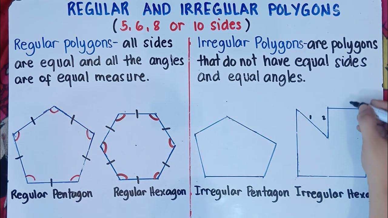
Regular and Irregular Polygons | Grade 7 | Matatag Curriculum | Quarter 1 |
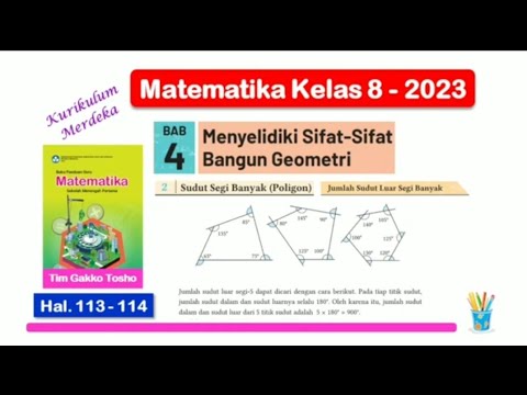
Matematika Kelas 8 Bab 4 - Sudut Luar Segi Banyak - hal. 113 - 114 - Kurikulum Merdeka

Materi Navigasi Darat - Pendidikan Dasar 41 PPA Sadagori
5.0 / 5 (0 votes)