Mystery of Nazca Lines May Finally Be Solved

BRIGHT SIDE
2 Sept 202309:08

Summary

TLDRThe Nazca Lines, a series of ancient geoglyphs in Peru, remain an enigma. Created over 2000 years ago, they feature animal shapes and geometric patterns, possibly serving as an astronomical calendar. Despite theories linking them to water rituals and communication, their true purpose remains a mystery. Recent discoveries by archaeologists using drones have unveiled more geoglyphs, suggesting they were used for communication and possibly celestial events. Similar geoglyphs worldwide, like the Candelabra of the Andes and the Blythe Intaglios, share the mystery of their ancient creators and purposes.

Takeaways

  • 🏜️ The Nazca Lines in Southern Peru are ancient geoglyphs, created over 2000 years ago by the Nazca culture, depicting various shapes and animals.
  • 🌍 The lines are still visible today due to the dry climate and strong winds that preserve them.
  • πŸ” The Nazca people created these lines by removing the top layer of pebbles to reveal the contrasting soil color underneath.
  • πŸ€” The exact purpose of the Nazca Lines remains a mystery, with theories ranging from astronomical markers to water rituals.
  • πŸŒ… One theory suggests that some lines point towards the setting sun, indicating a possible astronomical or calendar function.
  • 🏑 German scientist Maria Reiche, known as the 'Lady of the Lines,' dedicated her life to studying and protecting the Nazca Lines.
  • πŸ”¬ In the 1970s, American researchers proposed that the lines could be related to water rituals due to the arid climate of the region.
  • πŸ“ˆ Recent research by archaeologists from Yamagata University has identified new geoglyphs and used AI to analyze their patterns and purposes.
  • 🌐 Other geoglyphs around the world, such as the Paracas Candelabra in Peru and the Effigy Mounds in the U.S., also hold cultural and possibly astronomical significance.
  • πŸš€ The step geoglyphs in Kazakhstan, discovered on Google Earth, are another example of ancient earth art, with theories suggesting they tracked the sun's movement.

Q & A

  • What are the Nazca Lines?

    -The Nazca Lines are ancient geoglyphs located in the desert of southern Peru, featuring distinct white lines and shapes such as animals and geometric figures, created by the Nazca culture over 2000 years ago.

  • How were the Nazca Lines created?

    -The Nazca Lines were created by removing the top layer of pebbles to reveal the lighter-colored soil beneath, which contrasts with the reddish-brown surface.

  • Why are the Nazca Lines still visible today?

    -The Nazca Lines remain visible due to the dry climate and strong winds in the desert, which prevent erosion and preserve the designs.

  • What is the significance of the shapes found in the Nazca Lines?

    -The shapes in the Nazca Lines, such as monkeys, whales, and condors, are thought to have had astronomical, ritualistic, or symbolic meanings, with some theories suggesting they were used as a form of communication or calendar.

  • When were the Nazca Lines first discovered?

    -The Nazca Lines were first mentioned in the 16th century in the 'Chronicle of Peru,' but they became world-famous in the 1930s with the advent of commercial planes.

  • What role did Paul Kosok play in the study of the Nazca Lines?

    -American Professor Paul Kosok, while researching the lines, noticed that one of the lines pointed directly at the setting sun a day after the winter solstice, leading scientists to conclude that the lines might be the world's largest astronomy book.

  • What is the theory proposed by Maria Reiche regarding the Nazca Lines?

    -Maria Reiche, known as the 'Lady of the Lines,' supported the theory that the geoglyphs served as a calendar and had astronomical purposes, dedicating 40 years to studying and protecting the lines.

  • How do the animal images in the Nazca Lines relate to water?

    -The animal images in the Nazca Lines are associated with water; for example, spiders are thought to signify rain, hummingbirds represent fertility, and monkeys symbolize an abundance of water.

  • What recent advancements have been made in the study of the Nazca Lines?

    -Recent studies by archaeologists from Yamagata University using high-resolution aerial photography and drones have led to the discovery and cataloging of 358 geoglyphs, with 168 identified in 2022 alone.

  • What is the Candelabra geoglyph, and where is it located?

    -The Candelabra is a famous Peruvian geoglyph located on a seaside hill in the Paracas Peninsula, possibly dating back to around 200 BCE, and is thought to have been used as a beacon for navigation by sailors.

  • What are intaglios, and where can they be found?

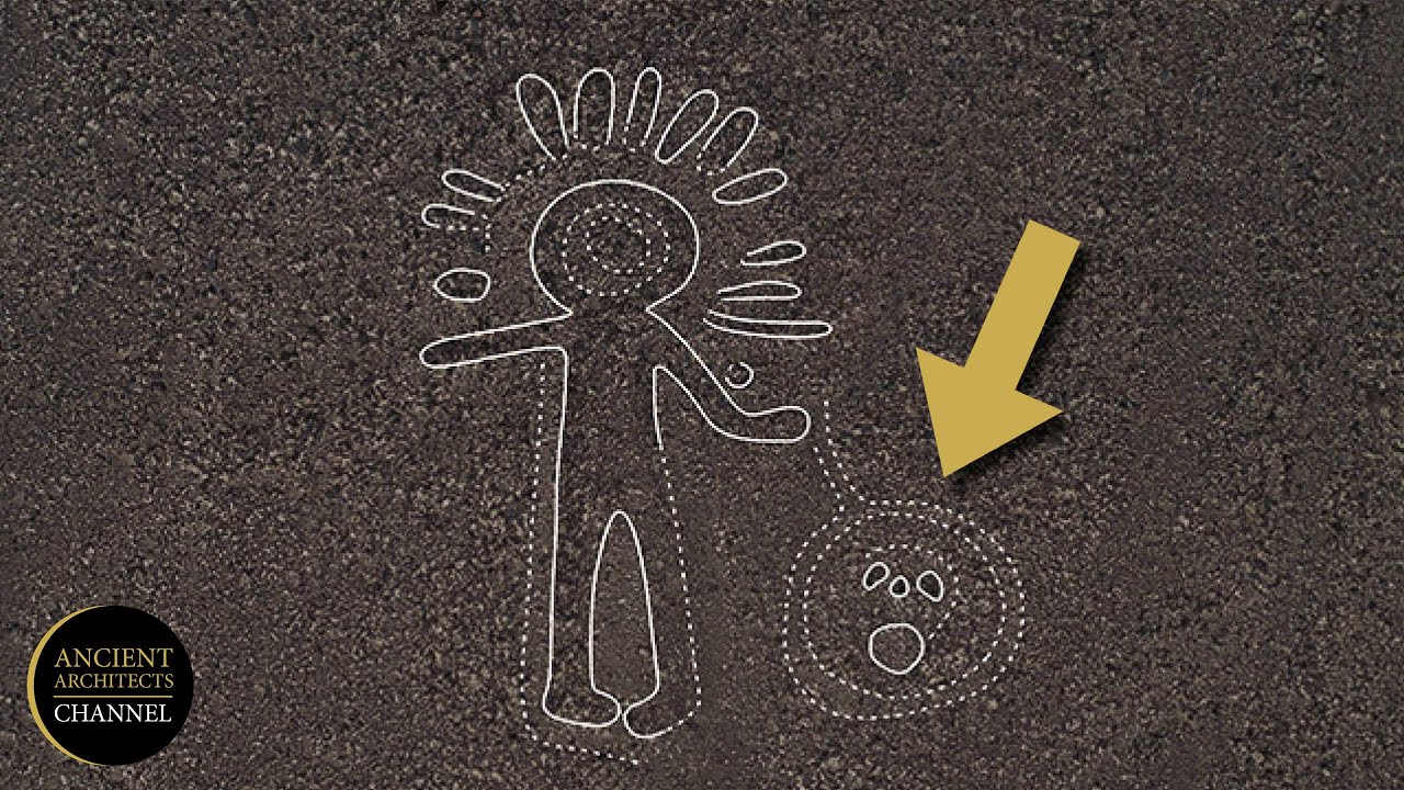
    -Intaglios are large, ground-engraved images, with over 300 examples found in the American Southwest and Mexico. The most famous are the Blythe Intaglios in California, which include figures of a human and an animal.

Outlines

00:00

🐘 The Nazca Lines of Southern Peru

This paragraph delves into the Nazca Lines, a series of ancient geoglyphs found in the deserts of Southern Peru. Created over 2000 years ago by the Nazca culture, these lines are best viewed from the air, revealing shapes like a monkey, a whale, and a condor. The Nazca people made these by removing the top layer of pebbles to expose the contrasting soil beneath. Scientists have been trying to understand the purpose of these lines since their discovery in the 1920s. Initially thought to be astronomical markers, with some pointing towards significant celestial events, alternative theories suggest they could be related to water rituals due to the region's arid climate. More recent research by Yamagata University archaeologists using advanced aerial photography and drones has identified over 350 geoglyphs, with some of the largest being as big as the Empire State Building. The Nazca Lines are now believed to have served as a form of communication, with different lines indicating pathways between settlements or valleys.

05:03

πŸ—ΊοΈ Geoglyphs Around the World

The second paragraph explores various geoglyphs from around the world. It begins with the Effigy Mounds National Monument on the Mississippi River, which features 195 Native American mounds shaped like animals and celestial events markers, dating back to 450 BCE. The American Southwest and Mexico are home to over 300 intaglios, with the Blythe Intaglios in California being particularly notable for their age and the mythological significance attributed by the local Mojave tribe. The paragraph also discusses the Step geoglyphs in Kazakhstan, which are geometric shapes built with materials like dirt and rocks, and are speculated to be over 8000 years old. The White Horse of Uffington in England, created between the Bronze and Iron Ages, is highlighted as one of the oldest chalk-cut hill figures, possibly serving as a fertility symbol or territorial marker. The paragraph concludes with an invitation for viewers to engage with the content by liking and sharing the video or exploring more videos on the channel.

Mindmap

Keywords

πŸ’‘Nazca Lines

The Nazca Lines are a series of ancient geoglyphs located in the Nazca Desert of southern Peru. They are characterized by large, intricate designs etched into the ground, visible from the air. The video script describes these lines as 'distinct, white lines against the rusty red background' and mentions shapes like straight lines, rectangles, triangles, and various animals. These lines, created by the Nazca culture more than 2,000 years ago, are significant as they are one of the main focal points of the video, illustrating ancient human creativity and the enduring mystery of their purpose.

πŸ’‘Geoglyphs

Geoglyphs are large designs or patterns on the ground that are typically created by removing the top layer of soil or vegetation to reveal the different-colored earth beneath. In the context of the video, geoglyphs are the primary subject, with the Nazca Lines being the most famous example. The script also mentions other geoglyphs from around the world, such as those in Kazakhstan and the Effigy Mounds in the United States, showcasing the global prevalence and cultural significance of these ancient designs.

πŸ’‘Astronomical Purposes

The concept of 'astronomical purposes' in the video refers to the theory that the Nazca Lines and other geoglyphs might have been used to track celestial bodies or events. The script discusses how some scientists, like Maria Risha, believed the Nazca Lines served as a calendar or had some sort of astronomical function, with certain lines pointing towards the setting sun on specific dates. This theory links the geoglyphs to ancient people's understanding and reverence of the cosmos.

πŸ’‘Desert

The desert is the natural environment where many of the geoglyphs discussed in the video are found, particularly the Nazca Lines. The script describes the desert as having a 'dry climate and strong winds,' which have helped preserve the Nazca Lines for thousands of years. The desert's harsh conditions and lack of vegetation make it an ideal location for geoglyphs to remain visible and intact over long periods.

πŸ’‘Archaeologists

Archaeologists are the scientists who study human history and prehistory through the excavation of sites and the analysis of artifacts and other physical remains. In the video, archaeologists from Yamagata University are mentioned for their work in using high-resolution aerial photography and drones to discover and catalog geoglyphs, demonstrating the ongoing research and technological advancements in the field of archaeology.

πŸ’‘Artificial Intelligence (AI)

Artificial Intelligence, or AI, refers to the simulation of human intelligence in machines that are programmed to think like humans and mimic their actions. In the context of the video, AI is used by researchers to analyze images of geoglyphs and generate designs that might be painted in the desert. This showcases how modern technology and computational methods are being applied to archaeological studies to uncover new insights and understand ancient human activities.

πŸ’‘Candelabra

The Candelabra is another geoglyph mentioned in the video, located on the Paracas Peninsula in Peru. It is described as 'slightly taller than the Washington Monument' and is etched deep into the sand. The video suggests that the Candelabra might have been used as a beacon for navigation by sailors, indicating its possible practical use in ancient times in addition to its symbolic or religious significance.

πŸ’‘Effigy Mounds

Effigy Mounds are earthen mounds shaped into the forms of animals or other figures. The video discusses the Effigy Mounds National Monument on the Mississippi River, which contains 195 known Native American mounds. These mounds, dating back to around 450 BCE, are believed to have served ceremonial purposes or marked celestial events, reflecting the cultural and spiritual practices of the ancient people who created them.

πŸ’‘Intaglios

Intaglios are large, geometric or representational designs that are incised or carved into the ground. The video mentions the Blythe Intaglios in California as an example, which include figures of a human and an animal. These geoglyphs, estimated to be between 450 and 2,000 years old, demonstrate the artistic and cultural expressions of ancient civilizations and their ability to create lasting monuments in the landscape.

πŸ’‘Chalk Cut Hill Figure

The Chalk Cut Hill Figure, specifically the White Horse mentioned in the video, is an ancient geoglyph created by removing the turf to reveal the chalky white part of the soil. This figure, located in Oxfordshire, England, is one of the oldest in Britain and has evolved over time due to the nature of the soil. It serves as an example of how geoglyphs can change and reveal additional layers of meaning or design over centuries.

Highlights

Distinct white lines and geometric shapes can be seen in the deserts of Southern Peru.

The Nazca Lines, created over 2000 years ago, are still visible today due to the dry climate and strong winds.

The Nazca people created the lines by removing the top layer of pebbles to reveal the contrasting soil color.

The lines include shapes resembling animals such as a monkey, whale, condor, and hummingbird.

Scientists have been trying to decipher the meaning of the Nazca Lines since their discovery in the 1920s.

American Professor Paul Kosok noticed the lines pointed at the setting sun one day after the winter solstice.

The lines are believed to be the largest astronomy book in the world, serving as a calendar with astronomical purposes.

German scientist Maria Reiche dedicated 40 years to studying the lines and protecting them from unwanted visitors.

In the 1970s, American researchers questioned the astronomy-related theory, suggesting the lines could be related to water rituals.

Images of animals in the Andes region are associated with water, fertility, and rain.

Archaeologists from Yamagata University are using high-resolution aerial photography and drones to study the geoglyphs.

In 2022, the team identified 168 new geoglyphs, including images of humans, camelids, birds, orcas, and snakes.

The Nazca Lines are thought to have been used as a form of communication, with linear ones pointing between valleys.

Scientists plan to use artificial intelligence to analyze the geoglyphs and find patterns in their distribution.

Another famous Peruvian geoglyph is the Candelabra, which may date back to around 200 BCE and could have been used for navigation.

Effigy Mounds National Monument contains Native American mounds that may have served as ceremonial sites or marked celestial events.

The American southwest has over 300 intaglios, with the Blythe Intaglios being the most famous, depicting a human and an animal.

Kazakhstan's geoglyphs, spotted on Google Earth in 2007, are a cluster of around 260 Earthworks that may date back 8,000 years.

The White Horse of Uffington in England, created between the Bronze and Iron Ages, is one of the oldest chalk cut hill figures.

Transcripts

play00:00

if you ever fly over the deserts of

play00:02

Southern Peru you'll notice distinct

play00:04

white lines against the rusty red

play00:07

background look closer and you'll see

play00:10

some clear shapes straight lines

play00:12

rectangles triangles swirls it seems

play00:16

like they're parts of huge drawings you

play00:18

notice a monkey a whale a condor a

play00:22

hummingbird and whatnot

play00:25

the lines were created more than 2 000

play00:28

Years Ago by the people of the Nazca

play00:30

culture thanks to a dry climate and

play00:33

strong winds in the desert most of the

play00:35

Nazca Lines are visible today to create

play00:38

them the Nazca people removed the top

play00:40

layer of Pebbles and revealed the soil

play00:43

beneath the ground the color of the soil

play00:45

changes from reddish brown to yellowish

play00:47

gray so the lines always look different

play00:50

it looks like the creators of the lines

play00:52

started with small scale models and

play00:55

increased the proportions to create

play00:57

full-scale designs

play01:00

scientists have tried to decipher the

play01:02

meaning of the Nazca Lines ever since

play01:04

they were first discovered in the 1920s

play01:06

but the first mention of the lines was

play01:09

actually much earlier in the 16th

play01:11

century Chronicle of Peru where they

play01:14

were described as Trail markers in the

play01:16

desert since you can't really study the

play01:18

lines and their symbolism from the

play01:20

ground the lines became world famous

play01:22

only in the 1930s with the Advent of

play01:25

commercial planes

play01:28

a decade later American Professor Paul

play01:31

kosok was doing his research on the

play01:33

lines and noticed one interesting thing

play01:35

when he looked up from the line it was

play01:38

pointing directly at the Setting Sun It

play01:40

Happened One day after the winter

play01:42

solstice and the scientists concluded

play01:44

that the lines must be the largest

play01:47

astronomy book in the world

play01:51

German scientist Maria Risha who got the

play01:54

nickname the lady of the lines supported

play01:57

the theory that the geoglyphs served as

play01:59

a calendar and had some sort of

play02:01

astronomical purposes she dedicated 40

play02:04

years of her life to studying the lines

play02:06

and swept them inch by inch she also

play02:10

moved into a small house close to the

play02:12

lines to protect them from unwanted

play02:14

visitors

play02:16

then in the 1970s American researchers

play02:19

called the astronomy related Theory into

play02:21

question they noted that in a region

play02:24

like Nazca one of the driest places on

play02:26

Earth with only around 20 minutes of

play02:28

rain per year water is a real treasure

play02:32

and the straight lines and trapezoids

play02:34

must have had something to do with it

play02:36

they could be pointing at locations for

play02:38

rituals that the local people organized

play02:40

to obtain water and make crops more

play02:43

fertile the images of animals in the

play02:45

Andes region are also related to water

play02:48

spiders are thought to be a sign of rain

play02:51

hummingbirds stand for fertility and

play02:54

monkeys living in the Amazon symbolize

play02:56

an abundance of water

play02:59

in more recent years the Nazca Lines

play03:01

have become the research ground for

play03:03

archaeologists from Yamagata University

play03:05

they're using high-resolution aerial

play03:08

photography and drones to discover and

play03:11

catalog geoglyphs the team has

play03:13

identified a total of 358 geoglyphs so

play03:16

far and 168 out of them in 2022 alone

play03:22

they found images of humans camelids

play03:25

Birds orca whales cats and snakes most

play03:28

likely created between 100 BCE and 300

play03:32

CE some of the images are around 10 to

play03:35

20 feet long so it's no wonder no one

play03:38

was able to detect them before the

play03:40

largest geoglyphs by comparison are 1200

play03:43

feet across which is about the height of

play03:45

the Empire State Building

play03:48

the researchers believe the Nazca Lines

play03:51

were used as a form of communication in

play03:54

the desert the linear ones pointed the

play03:56

direction from Valley to Valley the ones

play03:58

drawn on slopes seem to have been drawn

play04:01

along ancient Pathways between

play04:03

settlements

play04:04

the scientists now plan to find patterns

play04:07

in the geobliffs depending on their

play04:08

distribution they use artificial

play04:10

intelligence to analyze the images the

play04:13

AI generates designs that are likely to

play04:16

be painted in the desert and the team

play04:18

then checks if they're actually among

play04:20

the Nazca Lines

play04:22

another famous Peruvian geoglyph is a

play04:25

candelabra slightly taller than the

play04:28

Washington Monument you can find it on a

play04:30

Seaside Hill in the paracas peninsula

play04:33

researchers managed to establish the

play04:35

approximate age of the Candelabra by

play04:38

analyzing the nearby artifacts it looks

play04:40

like it dates back to around 200 BCE the

play04:44

drawing is etched deep into the sand and

play04:47

it was never meant to look like a

play04:48

candelabra one Theory says that the

play04:51

drawing was supposed to resemble the

play04:53

Trident of an incandeity to please it

play04:55

another popular theory is that Sailors

play04:58

used it as a beacon for navigation

play05:02

Effigy Mounds National Monument on the

play05:05

Mississippi River has 195 known Native

play05:08

American Mounds most of them are conical

play05:11

in shape and there are also several that

play05:13

look like birds deer Turtles bears and

play05:17

Panthers scientists have established

play05:19

that the Mounds date back to around 450

play05:22

BCE and the images are somewhat younger

play05:25

a study of the Mounds found some copper

play05:28

bone and stone tools the Builder's

play05:31

descendants say that the Mounds served

play05:33

as ceremonial sites this story is passed

play05:37

down from generation to generation some

play05:39

historians believe the Mounds could have

play05:41

been also used to Mark celestial events

play05:44

or territories

play05:46

the American southwest and the nearby

play05:48

regions of Mexico have over 300

play05:51

intaglios which are giant images

play05:53

engraved in the ground the most famous

play05:56

of them are the Blyth in taglios in

play05:58

California West of the Colorado River

play06:01

Blythe Giants are a group of six figures

play06:04

including that of a human being and an

play06:06

animal

play06:07

scientists believe the images are

play06:09

somewhere between 450 and 2 000 years

play06:12

old

play06:13

according to the local Mojave tribe

play06:15

there is an image of mustamhol the

play06:18

creator of Life the animal figure shows

play06:20

a mountain lion who served as his helper

play06:23

the largest figure is almost as tall as

play06:25

the Leaning Tower of Pisa the creators

play06:28

of the intaglios had to scrape the dark

play06:30

Rock of the desert until the lighter

play06:33

soil showed up it's nearly impossible to

play06:35

notice them from ground level that's why

play06:38

they were only discovered in the 1930s

play06:40

when a pilot flying over them

play06:42

accidentally looked down the best way to

play06:45

see the Giants is still from a

play06:46

helicopter

play06:48

Kazakhstan can boast its own Nazca Lines

play06:51

a cluster of around 260 Earthworks in

play06:55

the north of the country the step

play06:57

geoglyphs are a variety of geometric

play06:59

shapes including squares crosses circles

play07:03

and a three-prong design the creators of

play07:06

the images used materials such as dirt

play07:08

rocks and lumber to build them out of

play07:11

the ground a local Economist first

play07:13

spotted the geoglyphs while browsing

play07:15

Google Earth in 2007. archaeologists

play07:18

suppose that the structures go back 8

play07:21

000 years but they still don't know who

play07:23

built them or why one Theory says that

play07:27

the lines helped track the sun's

play07:28

movement

play07:31

NASA got interested in the discovery

play07:33

since the lines are much older than the

play07:35

ones in Peru they took photos of the

play07:38

step geoglyphs from space trying to

play07:40

solve their mystery another fact that

play07:42

makes the line so special is how huge

play07:45

they are one of the largest of them has

play07:47

sides as long as an aircraft carrier the

play07:51

only humans who could have built them

play07:52

must have been the nomadic Stone Age

play07:55

tribes but it's unlikely that they had

play07:57

such Advanced tools if they did that

play08:00

would mean that archaeologists need to

play08:02

rethink the abilities of our long ago

play08:04

ancestors organizing such a huge amount

play08:07

of people to work together on a

play08:09

complicated project is an amazing feat

play08:13

although the White Horse on a lush green

play08:15

hill in Oxford sure England could easily

play08:18

pass for Modern Art it's actually one of

play08:21

the most ancient geoglyphs it was

play08:23

created between the bronze and iron ages

play08:26

and is the oldest chalk Cut Hill figure

play08:29

in Britain whoever created it had to

play08:31

remove the turf to reveal the chalky

play08:34

white part of the soil scientists can

play08:36

only guess why this piece of art was

play08:38

created it could have been a fertility

play08:40

symbol or a way to Mark territory aerial

play08:44

images prove that the horse has changed

play08:46

over time because of the soil it took

play08:49

several centuries to reveal a larger

play08:51

horse-like shape that lies under what we

play08:54

see now

play08:57

that's it for today so hey if you

play09:00

pacified your curiosity then give the

play09:02

video a like and share it with your

play09:03

friends or if you want more just click

play09:05

on these videos and stay on the bright

play09:07

side

Rate This
β˜…
β˜…
β˜…
β˜…
β˜…

5.0 / 5 (0 votes)

Related Tags
Nazca LinesGeoglyphsAncient ArtDesert MysteryArchaeologyPeruvian CultureAstronomyHistorical SitesMystery SolvedAncient Civilizations