Mengenal Sistem Peringatan Dini Tsunami Indonesia (INATEWS) yang ada di BMKG
Summary
TLDRThis video highlights Indonesia's vulnerability to natural disasters, particularly tsunamis, due to its location along the Ring of Fire. It outlines the development of Indonesia's Tsunami Early Warning System (InaTEWS) by the government, which aims to prevent widespread damage and loss of life. The system operates through a network of seismographs and accelerometers, which relay data to BMKG for analysis. The BMKG issues warnings in stages, from initial alerts to real-time tsunami tracking. The video emphasizes the importance of public awareness and preparedness to minimize the impacts of tsunamis in Indonesia.
Takeaways
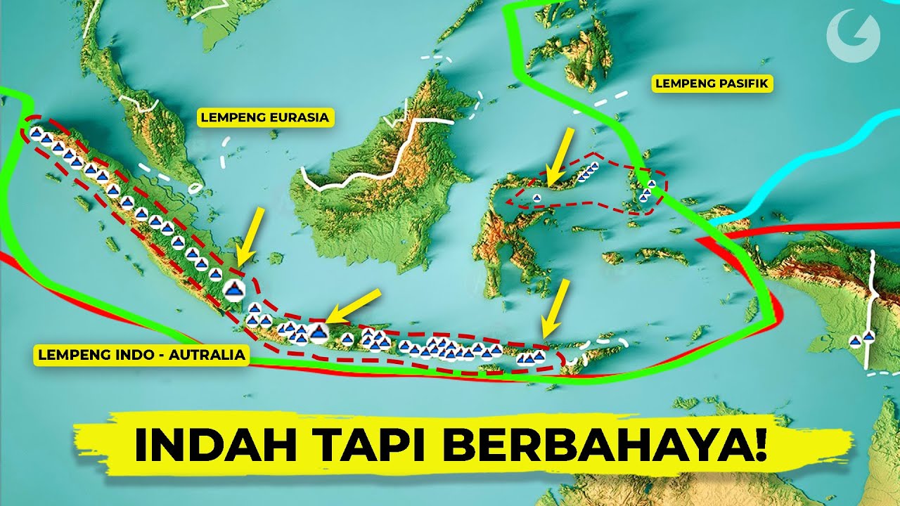
- 😀 Indonesia is an archipelagic country with great natural beauty, but it also faces significant disaster risks, especially due to its location along the Ring of Fire.
- 😀 Indonesia is highly prone to earthquakes and tsunamis, with notable events such as the 2004 Aceh Tsunami, the 2006 Pangandaran earthquake, the 2010 Mentawai earthquake, and the 2018 Palu and Donggala tsunami.
- 😀 To mitigate the impact of such disasters, the Indonesian government has developed the Indonesia Tsunami Early Warning System (InaTEWS).
- 😀 The Indonesia Tsunami Early Warning System involves multiple stakeholders in its development and operation, ensuring broad participation and preparedness.
- 😀 BMKG (Meteorology, Climatology, and Geophysics Agency) operates 176 seismographs and 336 accelerometers across Indonesia to monitor seismic activity.
- 😀 When an earthquake occurs, the seismographs send data to BMKG's central monitoring room, where personnel analyze the earthquake's location and potential for generating a tsunami.
- 😀 If the earthquake poses a tsunami risk, BMKG issues a first-level warning within 5 minutes, which is distributed to relevant agencies to begin preparations.
- 😀 BMKG also sends tsunami warning messages to radio and television stations to ensure the public is informed promptly.
- 😀 After the initial warning, BMKG continues to monitor the tsunami's potential, providing additional information about the expected timing and affected locations in subsequent warnings.
- 😀 A third-level warning is issued when the tsunami's wave height is recorded, and BMKG continues to monitor the waves, issuing updates and additional alerts as necessary.
- 😀 Once the tsunami has passed, BMKG issues a fourth-level warning to inform the public that the tsunami threat has ended.
- 😀 A reliable early warning system must be supported by a high level of public understanding and preparedness to reduce the overall impact of tsunamis in Indonesia.
Q & A
What natural disaster risks does Indonesia face due to its location?
-Indonesia faces significant risks of earthquakes and tsunamis because it is located along the 'Ring of Fire,' an area known for its seismic activity.
What were some major tsunamis that have impacted Indonesia?
-Indonesia has been affected by major tsunamis, including the 2004 Aceh tsunami, the 2006 Pangandaran tsunami, the 2010 Mentawai earthquake and tsunami, and the 2018 Palu and Donggala tsunamis.
What is the purpose of the Indonesia Tsunami Early Warning System (InaTEWS)?
-The purpose of the Indonesia Tsunami Early Warning System (InaTEWS) is to minimize damage and casualties by providing early alerts to relevant authorities and the public after a tsunami threat is detected.
Which agencies are involved in the operation of the tsunami warning system in Indonesia?
-The primary agency responsible for operating the tsunami warning system in Indonesia is the Meteorological, Climatological, and Geophysical Agency (BMKG).
How many seismographs and accelerators are used by BMKG in Indonesia for tsunami detection?
-BMKG uses 176 seismographs and 336 accelerators installed across Indonesia to monitor seismic activity and detect potential tsunamis.
How quickly does BMKG issue an initial tsunami warning after detecting a potential tsunami threat?
-BMKG issues the first tsunami warning within 5 minutes of detecting a potential tsunami threat based on seismic data analysis.
What is the purpose of the tsunami warning stages issued by BMKG?
-The tsunami warning stages help inform the public and relevant agencies about the severity and potential impact of the tsunami, providing details about the threat's location, timing, and expected waves.
What information is included in Warning 2 of the tsunami warning system?
-Warning 2 provides more specific information, including the expected time and location of the tsunami's impact.
What is the significance of Warning 3 in the tsunami warning system?
-Warning 3 confirms the magnitude of the tsunami and provides details about the expected wave height and impact, allowing for more precise evacuation and response efforts.
How does the public receive tsunami warnings in Indonesia?
-Tsunami warnings are disseminated to the public through various media channels, including radio and television, ensuring wide coverage and rapid communication.
Outlines

Этот раздел доступен только подписчикам платных тарифов. Пожалуйста, перейдите на платный тариф для доступа.
Перейти на платный тарифMindmap

Этот раздел доступен только подписчикам платных тарифов. Пожалуйста, перейдите на платный тариф для доступа.
Перейти на платный тарифKeywords

Этот раздел доступен только подписчикам платных тарифов. Пожалуйста, перейдите на платный тариф для доступа.
Перейти на платный тарифHighlights

Этот раздел доступен только подписчикам платных тарифов. Пожалуйста, перейдите на платный тариф для доступа.
Перейти на платный тарифTranscripts

Этот раздел доступен только подписчикам платных тарифов. Пожалуйста, перейдите на платный тариф для доступа.
Перейти на платный тариф


5.0 / 5 (0 votes)
