LOCATING PLACES USING COORDINATE SYSTEM I LATITUDE AND LONGITUDE I SCIENCE 7 QUARTER 4 WEEK 1
Summary
TLDRThis two-part tutorial series on 'Servas TV' explores the concept of locating places on Earth using a coordinate system. The first video delves into the imaginary lines found on maps and globes, such as latitudes and longitudes, which are crucial for determining a place's position. Latitudes, measured from the equator, affect climate, with the tropics experiencing a tropical climate and polar zones enduring cold temperatures year-round. Longitudes, starting from the Prime Meridian, divide the Earth into eastern and western hemispheres. The tutorial promises to apply these concepts in the second video to pinpoint locations on Earth, fostering a better understanding of geography and climate zones.
Takeaways
- 🌏 The video is part of a two-part tutorial series on locating places on Earth using a coordinate system.
- 🗺️ The script introduces the concept of imaginary lines on maps and globes, which are essential for finding the position of places.
- 📏 Latitude lines are horizontal and run from east to west, while longitude lines are vertical and run from north to south.
- ☀️ The equator is the starting point for latitude measurement, assigned a value of 0 degrees, and divides the Earth into the Northern and Southern Hemispheres.
- 🌡️ Latitude affects a place's climate, with the tropics experiencing a tropical climate and higher latitudes having colder temperatures.
- 🏞️ The tropics are the area between the Tropic of Cancer and the Tropic of Capricorn, known for warm temperatures.
- 🌤️ The Northern and Southern Temperate Zones lie between the tropics and the polar circles, characterized by four seasons.
- ❄️ The Polar Zones within the Arctic and Antarctic Circles experience cold temperatures year-round.
- 📍 The combination of latitude and longitude degrees can pinpoint exact locations on Earth.
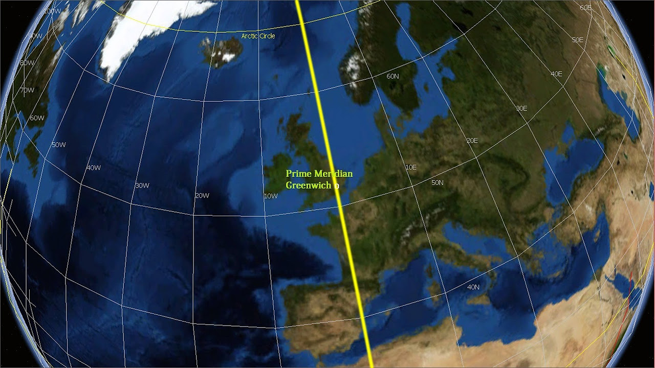
- 🌐 The Prime Meridian is the starting point for longitude measurement, located at 0 degrees, dividing the Earth into the Eastern and Western Hemispheres.
- 📘 The video concludes with a teaser for the next part of the series, where these concepts will be applied to locate places on Earth.
Q & A
What is the main focus of the two-part tutorial series by Servas TV?
-The main focus of the two-part tutorial series is to study how to locate places on Earth using a coordinate system and understanding imaginary lines on maps and globes.
What are the tools mentioned in the script that can be used to find the position of a place on Earth?
-The tools mentioned are compass, radar, GPS, maps, and globes.
What is a map and what does it represent?
-A map is a two-dimensional graphical representation of an area, land or sea, depicting physical features and can represent the whole or a part of the Earth.
What is a globe and how does it represent the Earth?
-A globe is a three-dimensional spherical model of the Earth, representing the world in a spherical form.
What are the horizontal imaginary lines on a map or globe called, and what is their purpose?
-The horizontal imaginary lines are called latitudes, and they are used to measure the distance of any place on the globe in degrees, running from east to west.
Why is the equator significant in the measurement of latitude?
-The equator is significant because it is the starting line of latitude measurement and is assigned a latitude value of 0 degrees, dividing the Earth into the northern and southern hemispheres.
How does the latitude of a place relate to its climate?
-The latitude of a place affects its climate, with places closer to the equator experiencing warmer temperatures and those closer to the poles experiencing colder temperatures.
What are the vertical imaginary lines on a map or globe called, and how do they differ from latitudes?
-The vertical imaginary lines are called longitudes, and they run from north to south, differing from latitudes which run from east to west.
What is the prime meridian and its role in measuring longitude?
-The prime meridian is the starting point for measuring longitude, located at 0 degrees, and it divides the Earth into the western and eastern hemispheres.
How can the combination of latitude and longitude be used to locate any place on Earth?
-By combining latitude and longitude, we can pinpoint exact locations on Earth, as these coordinates provide a precise reference point on maps or globes.
What are the four climatic zones mentioned in the script and how do they differ in terms of temperature and seasons?
-The four climatic zones are tropics, northern temperate zone, southern temperate zone, and polar or frigid zones. The tropics have a warm climate with temperatures above 18 degrees Celsius, while the temperate zones experience four seasons. The polar zones have cold temperatures year-round.
Outlines
🌏 Understanding Earth's Coordinate System
This introductory paragraph sets the stage for a two-part tutorial series on locating places on Earth using a coordinated system. The video will explore imaginary lines on maps and globes and apply these concepts to find the position of places on Earth. It invites viewers to learn about the various tools like compasses, radar, GPS, maps, and globes that can be used for this purpose. The paragraph introduces the concept of maps and globes, which are graphical representations of the Earth's surface, and highlights the importance of horizontal and vertical imaginary lines, known as latitudes and longitudes, in locating places on Earth. It also touches upon the impact of a place's latitude on its climate, explaining the division of the Earth into tropical, temperate, and polar zones.
📍 Navigating with Latitudes and Longitudes
The second paragraph delves deeper into the specifics of latitudes and longitudes, the imaginary lines that allow for the precise location of any place on Earth. It explains that latitudes run east to west and are measured in degrees from the equator, which is at 0 degrees latitude. The equator divides the Earth into the northern and southern hemispheres, each extending up to 90 degrees towards the poles. The paragraph also describes the significance of notable latitudes like the Tropic of Cancer and the Arctic Circle, which define the tropical, northern temperate, and polar zones. It then transitions to longitudes, which run north to south, with the Prime Meridian as the starting point at 0 degrees. The Prime Meridian divides the Earth into the eastern and western hemispheres, with longitudes extending 180 degrees in both directions. The paragraph concludes by emphasizing the combination of latitude and longitude to pinpoint any location on a map or globe, setting the stage for the next video where these concepts will be applied to locate places on Earth.
Mindmap
Keywords
💡Coordinated System
💡Latitude
💡Longitude
💡Equator
💡Tropic of Cancer
💡Tropic of Capricorn
💡Arctic Circle
💡Antarctic Circle
💡Globes
💡Maps
💡Climate
Highlights
The tutorial series will teach how to locate places on Earth using a coordinated system.
The first video will review imaginary lines on maps and globes.
The second video will apply these concepts to locate places using coordinates.
Different climates and weather are related to a place's position on Earth.
Tools like compass, radar, GPS, maps, and globes can find a place's position.
A map is a 2D representation, while a globe is a 3D model of Earth.
Maps and globes share horizontal and vertical imaginary lines.
Latitude lines run east-west and are measured in degrees from the equator.
The equator is at 0 degrees latitude and divides the Earth into hemispheres.
Latitude affects a place's climate, with the tropics experiencing a tropical climate.
The tropics are between the Tropic of Cancer and Tropic of Capricorn.
The temperate zones are between the tropics and the polar circles.
Polar or frigid zones are within the Arctic and Antarctic circles, with cold temperatures.
Latitude proximity to the equator correlates with warmer temperatures.
Longitude lines run north-south, starting from the Prime Meridian.
The Prime Meridian is at 0 degrees longitude, dividing the Earth into eastern and western hemispheres.
Combining latitude and longitude can pinpoint any place on Earth.
The tutorial will show how to apply these concepts in the next video.
Transcripts
[Music]
ugh amazing this is serva
subservas tv in this two-part tutorial
series video
we are going to study how can we locate
places on earth
using a coordinated system in the first
video we are going to review the
different imaginary lines
that can be found on a map and a globe
and on the second video we are going to
apply the concepts about imaginary lines
in locating places on earth using a
coordinated system
are you ready to learn if you find this
video helpful please do not forget to
subscribe to this channel
do not forget to like share and comment
hashtag
amazing let's go
have you ever wondered why different
places on earth
have different climates and weather why
other countries experience no and why
our country the philippines does not
experience
this phenomenon this phenomenon has
something to do with the position of a
place
or a country on earth but how can we
find the position of a place
on earth different tools can be used in
finding the position of a place
can you please give examples correct
some of these are compass radar
gps maps and globes
in this video we are going to focus
on maps and globes to find the position
of a place
a map is a two-dimensional graphical
representation of an area
land or sea depicting physical features
it can represent the wool or a part of
the earth
on the other hand a globe is a
three-dimensional
spherical model of the earth it
represents
the world earth observe the map and the
globe
what do they share in common you are
right
both the map and the globe are made of
horizontal lines
and vertical lines which intersects with
each other
we cannot really see these lines on the
surface of the earth
hence they are called imaginary lines
these imaginary lines are very important
in locating places on earth
the horizontal imaginary lines that run
from east to west of
a map or a globe are called latitudes
since the earth is a sphere the distance
of any place in the globe
is measured in degrees the starting line
of latitude measurement is the equator
therefore the equator is assigned a
latitude value of 0 degree
the equator is read as 0 degree latitude
the equator divides the earth into
northern hemisphere
and southern hemisphere the northern
hemisphere is an area located above the
equator
up to the north pole it extends above
the equator to 90 degrees
going up on the other hand the southern
hemisphere is
an area located below the equator
down to the south pole it extends below
the equator to 90 degrees
going down the notable latitudes are
shown in the picture and they are given
special names
the latitude of a place has something to
do with its climate
the part of the world between the tropic
of cancer
and the tropic of capricorn is called
tropics
countries located in this zone
experience a tropical climate
where the annual average temperature is
above
18 degrees celsius this is the reason
why the philippines
is a tropical country we experience
warm temperatures between the tropical
cancer
and the arctic circle is the northern
temperate zone
and between the tropic of capricorn and
the antarctic circle
is the southern temperate zone countries
located in the zones experience
four seasons winter spring
summer and autumn areas within the
arctic circle and the antarctic circle
are called polar or frigid zones
countries located in the zones
experience cold temperature
all year round based on this we can say
that the closer the latitude is to the
the warmer the temperature and the
closer it is to the poles
the colder the temperature aside from
the horizontal imaginary lines
we also have vertical imaginary lines
these vertical imaginary lines that run
from north to south
of a map or a globe are called
longitudes
they extend from photopole on a globe
to easily visualize the longitudes let
us use this map
the starting point for measuring
longitude is the primed region
which is located on 0 degree it is
referred to as
0 degree longitude the primal region
divides the earth into another
pair of hemispheres the western
hemisphere
and the eastern hemisphere the western
hemisphere extends from the primary
region
to 180 degrees going to the left
meanwhile the eastern hemisphere extends
from the prime
region to 180 degrees going right
the latitude and longitude degrees
represent
exact places on earth when these
latitudes
and longitudes are combined we can
locate
any place on a mop or a globe in this
video you learn that there are two
imaginary lines
that can be found on a map or a globe
the latitudes and the longitudes the
equator is located on the zero degree
that it should
it divides a map or a globe into
northern and southern hemisphere
the primary region is located at zero
degree longitude
it divides a mop or a globe into eastern
hemisphere and western hemisphere
in our next video we are going to apply
these concepts
to locate places on earth see you on our
next science lesson
ag amazing
[Music]
[Music]
[Music]
[Music]
do
[Music]
you
関連動画をさらに表示
Latitude and Longitude
Equatorial Coordinate System Explained: How Astronomers Navigate the Celestial Sphere
How to read Latitude and Longitude Coordinates
BA 2nd semester geography prectical viva voce || general cartography practical viva ||
What are PRESSURE BELTS ? 🤔 Through Animation | OnlyIAS
Where is it? Celestial coordinates explained
5.0 / 5 (0 votes)