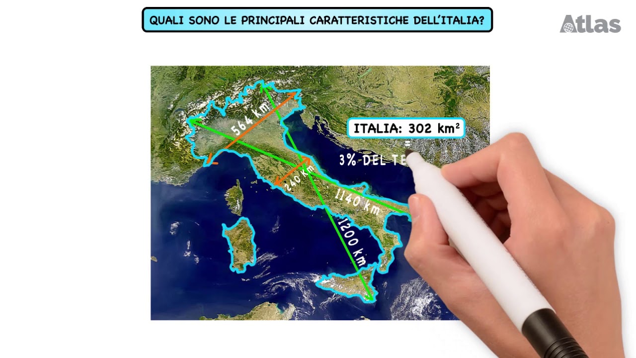
The RELIEVES OF MEXICO: types and their characteristics⛰️
Summary
TLDRThis video explores the diverse and complex reliefs of Mexico, from its vast plains and plateaus to its towering mountain ranges and active volcanic regions. It highlights the major geological features, including the Neovolcanic Axis, the Sierra Madre ranges, and the significant volcanic activity in the country. The script also delves into Mexico's valleys, depressions, basins, and coastal landscapes, emphasizing the country's tectonic history and the significant impact of the Pacific Ring of Fire. Additionally, the video covers Mexico's insular and submarine reliefs, making it a comprehensive overview of the country's varied topography.
Takeaways
- 😀 Mexico's relief features diverse landscapes, including mountain ranges, plateaus, coastal plains, and volcanic areas.
- 😀 The highest point in Mexico is Pico de Orizaba (Citlaltépetl), a volcano at 5,610 meters above sea level, located between Puebla and Veracruz.
- 😀 Mexico's lowest area is Laguna Salada in Baja California, which is 12 meters below sea level.
- 😀 The Mexican territory is geologically divided between the North American plate and the Caribbean plate, contributing to volcanic activity.
- 😀 Plains in Mexico are expansive, including regions like the Sonoran plain and the Great Plain of North America, as well as coastal plains on both the Atlantic and Pacific coasts.
- 😀 The Yucatán Peninsula is a calcareous platform with plains, low hills, and a network of caves and cenotes due to its geology.
- 😀 The Meseta del Centro (Mexican Highlands) is the most prominent plateau, with elevations ranging from 1,100 meters in the north to 2,000 meters in the south.
- 😀 Mexico is home to several mountain ranges, including the Sierra Madre Occidental, Sierra Madre Oriental, and the Neovolcanic Axis, which runs from west to east.
- 😀 Mexico's volcanic activity is concentrated along the Neovolcanic Axis, where many active volcanoes, including Popocatépetl and Colima, pose a threat to nearby cities.
- 😀 Mexico's coastal and submarine relief features include deep ocean trenches, such as the Central American Trench and the Gulf of Baja California Trench, which result from tectonic subduction and plate movements.
Q & A
What is the highest peak in Mexico and where is it located?
-The highest peak in Mexico is Pico de Orizaba, also known as Citlaltépetl, with an elevation of 5,636 meters above sea level. It is located between the states of Puebla and Veracruz, on the Neovolcanic Axis.
What geological plates contribute to the volcanic activity in Mexico?
-The volcanic activity in Mexico is primarily due to the interaction between the North American plate and the Caribbean plate, with the subduction of the Caribbean plate beneath the North American plate causing tectonic activity and volcanic formations.
What is the significance of the Neovolcanic Axis in Mexico's geography?
-The Neovolcanic Axis, or Trans-Mexican Volcanic Belt, is a major geological feature that runs from west to east across Mexico, hosting numerous volcanoes and marking a division between the northern and southern regions of the country. It includes Mexico's highest peak, Pico de Orizaba.
What are cenotes, and where are they most commonly found in Mexico?
-Cenotes are natural wells or sinkholes formed by the collapse of limestone bedrock, exposing groundwater beneath. They are particularly common in the Yucatán Peninsula, which has a network of these caves and channels due to its calcareous geology.
What are the major mountain ranges in Mexico?
-Mexico has several major mountain ranges, including the Sierra Madre Occidental, Sierra Madre Oriental, Sierra Madre del Sur, Sierra Madre de Chiapas, and the Neovolcanic Axis. These ranges are integral to the country's topography and contribute to its diverse climates.
What is the Balsas Depression, and what is its geographic significance?
-The Balsas Depression is a large basin located between the Sierra Madre del Sur and the Neovolcanic Axis. It covers almost 6% of Mexico's territory and has an average elevation ranging between 300 and 600 meters above sea level.
How do Mexico's coastal plains differ along the Pacific and Atlantic coasts?
-Mexico's coastal plains differ in width and geography. On the Pacific coast, the plains are broader in the north (around 500 km wide) and narrower in the south (about 50 km). The Atlantic coast, including the Gulf of Mexico, has plains such as the Sonoran plain and the plains along the Gulf of Mexico.
What is the geographical importance of the Yucatán Peninsula in Mexico?
-The Yucatán Peninsula is a calcareous platform that emerged from the sea, featuring plains and low hills. Its unique calcareous geology contributes to the region's network of cenotes and caves, making it a notable feature in Mexico's geography.
What is the difference between the islands in the Atlantic and Pacific coasts of Mexico?
-The islands in the Atlantic and Caribbean regions of Mexico are generally small and of reef origin, while those in the Pacific are typically continental islands formed by mountainous outcrops or volcanic islands, such as the Revillagigedo archipelago.
What impact did the Chicxulub meteorite have on Mexico's geography?
-The Chicxulub meteorite, which impacted the Gulf of Mexico 66 million years ago, created a large underwater crater off the coast of the Yucatán Peninsula. This event is associated with the mass extinction of the dinosaurs.
Outlines

Esta sección está disponible solo para usuarios con suscripción. Por favor, mejora tu plan para acceder a esta parte.
Mejorar ahoraMindmap

Esta sección está disponible solo para usuarios con suscripción. Por favor, mejora tu plan para acceder a esta parte.
Mejorar ahoraKeywords

Esta sección está disponible solo para usuarios con suscripción. Por favor, mejora tu plan para acceder a esta parte.
Mejorar ahoraHighlights

Esta sección está disponible solo para usuarios con suscripción. Por favor, mejora tu plan para acceder a esta parte.
Mejorar ahoraTranscripts

Esta sección está disponible solo para usuarios con suscripción. Por favor, mejora tu plan para acceder a esta parte.
Mejorar ahora


5.0 / 5 (0 votes)
