Earthquake and Volcanic Eruptions | Philippines History
Summary
TLDRThis script explores the dynamic nature of Earth, focusing on the Philippines' formation through the forces of plate tectonics, volcanic eruptions, and earthquakes. It delves into the Pacific Ring of Fire's impact, the creation of the Philippine archipelago, and the significance of Mount Pinatubo and Taal Volcano. The narrative highlights the balance between destruction and creation, showcasing how volcanic activity enriches ecosystems, contributes to agriculture, and powers geothermal energy, reflecting Earth's ever-evolving landscape.
Takeaways
- 🌏 The Earth is constantly moving and changing, with natural processes like plate tectonics shaping its surface over time.
- 🌊 Oceanic plates become denser as they age, causing them to subduct under other plates, leading to volcanic activity and earthquakes.
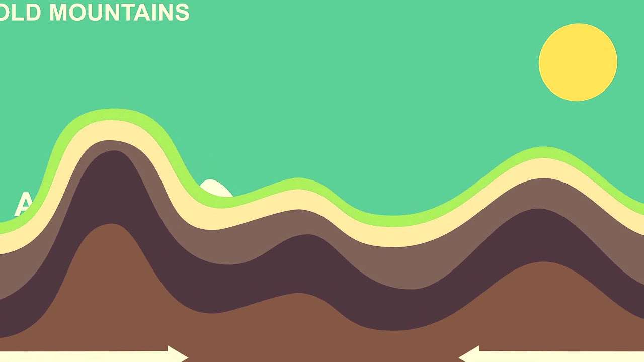
- 🌋 Volcanic eruptions and earthquakes are part of the natural geological processes that have formed islands like the Philippines.
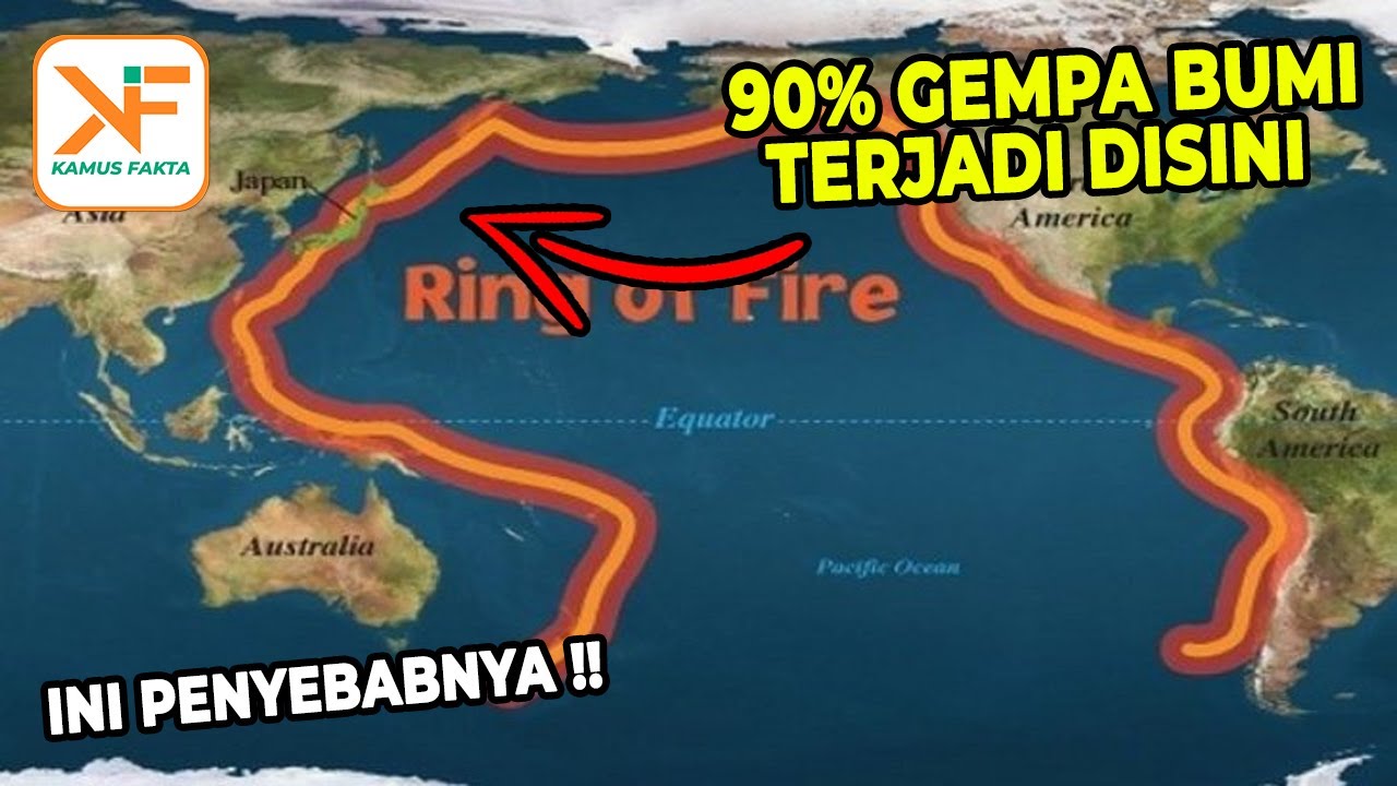
- 🔥 The Pacific Ring of Fire, stretching across 40,000 kilometers, is a high-risk zone for earthquakes and volcanic eruptions.
- 🌍 The continents were once part of a supercontinent called Pangaea, which broke up due to continental drift and sea floor spreading.
- 🏞️ The formation of the Philippine Islands is a result of the complex tectonic movements at the boundaries of the Philippine Sea Plate and the Eurasian Plate.
- 🚨 The Philippine Fault, with its north-south direction, has been the source of major earthquakes in the country.
- 🌊 Tsunamis can be triggered by undersea disturbances such as earthquakes, landslides, or volcanic eruptions.
- 🌋 Volcanoes like Mount Hibok-Hibok and Mount Pinatubo are part of a chain of volcanoes in the Philippines, formed by the subduction of the Eurasian Plate.
- 🏔️ Mount Mayon, known for its perfect cone, is maintained by symmetrical lava distribution from its eruptions.
- 🌱 Volcanic activity contributes positively to the ecosystem by enriching soil for agriculture and creating habitats for flora and fauna.
Q & A
What causes the Earth's oceanic plates to move deeper into the upper mantle?
-As the Earth ages, the oceanic plates become denser, which causes them to sink deeper into the upper mantle.
What is the result of the friction between tectonic plates?
-The friction between tectonic plates can create volcanoes and trigger earthquakes.
How were the Philippine Islands formed?
-The Philippine Islands were formed by the natural forces of plate tectonics, including volcanic activity and earthquakes, at the Pacific Ring of Fire.
What is the Pacific Ring of Fire?
-The Pacific Ring of Fire is a high-risk zone for earthquakes and volcanic activity that stretches across 40,000 kilometers from the southern tip of South America to New Zealand.
What was the supercontinent that existed 250 million years ago?
-Pangaea was the supercontinent that existed 250 million years ago, formed by the churning and circulation in the Earth's mantle.
How did the breakup of Pangaea influence the Earth's history?
-The breakup of Pangaea into the seven continents we know today was influenced by continental drift and sea floor spreading, dictating the planet's geological history.
What is the Philippine Fault and its significance?
-The Philippine Fault is a fault zone with a north-south direction that has been the source of major earthquakes in the country, such as the one on July 16, 1990.
What is a tsunami and what triggers it?
-A tsunami is a series of ocean waves triggered by disturbances at the sea floor, such as faults rupturing beneath the ocean, undersea landslides, or volcanic eruptions.
How does volcanic activity contribute to the formation of new habitats?
-Volcanic activity can create new habitats by providing fertile soil rich in minerals, which benefits the growth of plants and supports diverse ecosystems.
What is the significance of Mount Mayon's perfect cone shape?
-Mount Mayon's perfect cone shape is maintained by the symmetrical distribution of volcanic deposits on all its sides, which repairs the crater after each eruption.
How does volcanic activity impact the Philippines' economy?
-Volcanic activity in the Philippines contributes to the economy through the production of minerals like sulfur, copper, and gold, as well as the generation of geothermal energy and the creation of lahar cement for construction.
Outlines
🌏 Dynamic Earth and the Birth of the Philippine Islands
This paragraph delves into the natural processes that shape our planet, focusing on the constant movement of Earth's plates and the formation of the Philippine Islands. It explains how the increased density of oceanic plates leads to their subduction, creating friction that results in volcanic activity and earthquakes. This geological activity has been instrumental in the creation of the archipelago. The text also touches on the Pacific Ring of Fire, a high-risk zone for earthquakes and volcanic eruptions, and how the Earth's continents, including the Philippines, have been shaped by these forces over millions of years.
🌋 Volcanic Activity and Tsunamis in the Philippines
The second paragraph discusses the Philippines' susceptibility to powerful earthquakes and destructive tsunamis. It describes how tsunamis are triggered by disturbances at the sea floor, such as faults rupturing beneath the ocean or undersea landslides and volcanic eruptions. The country's unique tectonic setting, located at the boundaries of the Philippine Sea Plate and the Eurasian Plate, makes it prone to volcanism. The paragraph highlights the formation of volcanic islands like Camille and the high concentration of volcanic formations on Camiguin Island, which is home to the stratovolcano Mount Hibok-Hibok. It also mentions the potential for volcanic activity to have positive impacts, such as providing fertile soil for agriculture and generating geothermal energy.
🏞️ The Impact of Volcanic Activity on the Philippines' Landscape and Economy
This paragraph explores the lasting and life-changing impact of volcanic activity on the Philippines' landscape, ecology, and economy. It describes how volcanoes, such as Mount Mayon, maintain their shape through continuous lava flow and how volcanic soil enriches farming conditions, benefiting local agriculture. The text also covers the benefits of geothermal energy, with the Philippines being a major producer, and the extraction of minerals from volcanic activity. Additionally, it discusses the use of volcanic materials in construction, such as lahar cement, and the importance of studying volcanoes to understand the Earth's interior and predict natural phenomena.
Mindmap
Keywords
💡Tectonic Plates
💡Subduction
💡Volcano
💡Pacific Ring of Fire
💡Mantle
💡Pangaea
💡Volcanic Eruption
💡Stratovolcano
💡Geothermal Energy
💡Tsunami
💡Lahar
Highlights
The Earth's dynamic nature is exemplified by the constant movement of tectonic plates, leading to natural phenomena such as earthquakes and volcanic eruptions.
The Philippine Islands were formed by the same forces that cause earthquakes and volcanoes at the Pacific Ring of Fire.
The Pacific Ring of Fire, stretching across 40,000 kilometers, is a high-risk zone for seismic and volcanic activities.
250 million years ago, the supercontinent Pangaea existed due to the churning and circulation in the Earth's mantle.
The breakup of Pangaea into today's continents was influenced by continental drift and sea floor spreading.
The Philippine Fault, with its north-south rupture, has been the source of major earthquakes in the country.
Tsunamis can be triggered by disturbances at the sea floor, intense shaking from shallow earthquakes, or undersea landslides and volcanic eruptions.
The Philippines' unique tectonic setting makes it ideal for volcanism, with the Philippine Sea Plate and Eurasian Plate subducting beneath the archipelago.
Volcanoes provide insights into the Earth's interior, helping researchers understand its composition and history.
Mount Mayon's perfect cone shape is maintained by the even distribution of volcanic deposits during eruptions.
Volcanic activity contributes positively to the ecosystem, providing fertile soil for agriculture and creating new habitats for flora and fauna.
The Philippines is the third largest geothermal energy producer in the world, thanks to its volcanic activity.
Volcanic materials, such as those from Mount Pinatubo, are used in the production of lahar cement for construction.
Volcanoes and earthquakes are common occurrences in the Earth's long history, shaping the natural world in dramatic ways.
Studying volcanoes and Earth's movements helps us understand the planet's past, present, and future.
The eruption of Mount Pinatubo in 1991 was a major event, but today it is a popular tourist destination for its beauty.
Taal Lake's volcanic island is a result of small eruptions within the caldera formed by catastrophic eruptions and geological processes.
Mount Canlaon provides rich volcanic soil for farming, enhancing the livelihood of local farmers.
Transcripts
if our planet and your place in it
seems calm and quiet that's because
you are looking at and experiencing
a tiny and considerably pleasant slice
of time
and space
[Music]
now you're seeing the earth moving
plates
as the earth ages the oceanic plates
become
denser this increased density causes
them to ride deeper
into the upper mantle
eventually a section of the oceanic
plate will separate
and withdraw under the other part of the
other oceanic plates
the friction between the plates create
volcanoes and the waves of
earthquakes the world belches
splits sizzles breaks apart
but the planet is still fine you just
have to trust the process
because all of these happen normally
naturally every day
and all of these forces have given birth
to an archipelago
we now know as the philippine islands
a massive golem of smoke and ash shoots
into the sky
fountains of lava flow above its crater
as ash plumes rise up
pyroclastic flows or superheated gas and
volcanic debris raised down the slopes
at high speeds
while the volcano is vomiting molten
lava and belching smoke
more violent rumblings occur
for thousands of years these events have
been recorded around the earthquake
prone volcanic
belt in the pacific known as the pacific
ring of fire
the pacific ring of fire spreads across
40 000 kilometers
from the southern tip of south america
all the way
to new zealand that's one big
high-risk zone the philippines and most
of its islands were created by the
forces that spawned earthquakes and
volcanoes
at the pacific ring of fire
the earth is a dynamic and constantly
moving planet
in fact 250 million years ago
long before even the age of dinosaurs
the earth's seven continents were all
grouped together
into one massive supercontinent called
pangaea pangaea was formed as a result
of the churning and circulation
in the earth's mantle most activities
punctuated by earthquakes and volcanic
eruptions stem from this interplay where
the plates meet
or divide due to the continental drift
and sea floor spreading
pangaea broke up into the seven
continents we know today
this breakup and transformation dictated
the planet's history
complex movements underneath these
plates for example
formed and shaped the very first islands
of the philippines
palawan and mindoro
[Music]
the pacific and australian plates then
moved inward to the eurasian plate
causing the main islands of luzon and
mindanao
to emerge and pushing the islands of
palawan and mindoro to move
closer to the newly developed blue zone
in mindanao
mainlands the movements of these plates
continued to push inward to asia
thus creating the more than 7 000
islands of the philippines
the philippines has its own system of
thoughts which stretches from north
to south from
above we can see a rupture which has
displaced a road in the town of gabaldon
way by sia
these cracks and fractures are the
result of the colliding plates that run
almost in a parallel north to south
direction
of the philippine fault zone called the
philippine fault
[Music]
it has been the source of a handful of
major earthquakes in the country
like the july 16 1990 quake that shook
the entire island of luzon
the valley fault system is divided into
the west valley fault and the east
valley fault
the falls extend from bulacan rizal
laguna
metro manila
as the philippines is prone to large
powerful earthquakes
it is also not spared from destructive
tsunamis
tsunamis are triggered by disturbances
at the sea floor
they displace a significant amount of
sea water
as faults rupture beneath the ocean
sometimes it can also occur due to
intense shaking caused by
a shallow earthquake that emanates along
the coast
but tsunamis can also be the result of
undersea landslides or volcanic
eruptions
the philippines is positioned on a
unique and sometimes complex tectonic
setting
that is ideal to volcanism
as it is located at the boundaries of
the philippine sea plate in the eurasian
plate
both subduct or dive beneath the
archipelago
along the deep trenches along its east
and west seaboard
an island can be of volcanic origin that
is formed when two oceanic plates meet
the origin of the pearl-shaped island of
camille
for example located northeast of the
island of mindanao
can be explained on the same line
it's sunken cemetery is postcard worthy
a huge cross was installed in 1982
to mark the spot where the old cemetery
sank
when mount hebokebuk erupted in 1871
[Music]
its name was derived from the kamagong
trees that abound in the area
but beyond that kamighin has also earned
the distinction
of having more volcanic formations per
square kilometer
than any other island on earth
truly a hot plate
the island was literally born of fire
the island itself was formed out of
different volcanoes
the most popular of which is mount
hibokibo
volcanologists classify mount hebokebok
as a stratovolcano dome
complex a volcano built up of
alternate layers of lava and ash
it contains several lava domes including
mount vulcan
its most recent explosive eruption
happened in 1951
although mount ebook ebook is classified
as an active volcano it shows no
signs of activity today the only signs
of volcanism are the hot springs around
the foot of the mountain
it's now a popular hiking destination in
kamighin
island reaching the summit exposes the
mossy crater of hebrew kibo's past
eruptions
but the views are spectacular
[Music]
all these elements make hibok hebo less
terrifying
despite its explosive history
this is mount pinatubo
it is part of a chain of composite
volcanoes along the west coast of the
mainland luzon
the arc of volcanoes in this area is a
result of the subduction of the eurasian
plate along the manila trench to the
west of the philippines
the killer quake of 1990 was believed to
be a catalyst to the major eruption
of pinatubo in 1991
but today the inferno's mouth is calm
beautiful after 27 years
more than 3 000 tourists climb mount
pinatubo every month to simply marvel
at its beauty
[Music]
just like mount pinatubotal volcano is
part of a
chain of volcanoes along the western
side of luzon
ta'al lake lies within a 25 to 30
kilometer
basin formed by a series of catastrophic
eruptions
and other geologic processes
thousands of years ago large-scale
magmatic activity was very common
in this part of luzon that includes the
caldera forming
explosion since the formation
of the caldera small eruptions created
another volcanic island within the basin
this is what we see as the volcanic
island what filipinos now refer to as
the
volcano tal's latest eruption only
proves that
our land is in a constant state of
evolution
and its impact is lasting and life
changing
volcanoes may elude to images of death
and widespread devastation
but for those who study the earth's
deepest
behaviors volcanoes are also
windows to the interior of our planet
their activities and non-activities help
researchers
unravel the composition and history of
the earth's core
such is the beauty of dragan magayon in
albay
mount mayon's iconic perfect cone is a
breathtaking view that makes albay a
prime tourist destination in the region
it towers over albay and can be seen
from
anywhere in the province but while mayon
is considered the most active volcano in
the philippines
why was its perfect cone not damaged by
past eruption
the crater of mayon is constantly
repaired by the lava its pews
over the years the volcano maintains
its symmetrical cone precisely because
of the distribution of volcanic deposits
on all its sides
intense volcanic activity can also have
a positive impact
on the ecosystem
[Music]
mount canlaon in negros occidental
brings farmers rich volcanic
soil the chemical makeup of volcanic
soil makes for
lucrative farming conditions for example
for pineapple growers in the area
the fertile fields are rich in iron
deposits
benefiting farmers whose lives depend on
their crops
it also provides a good environment for
the formation of new habitats
for animals plants and insects
hot springs and geothermal energy are
additional benefits
the philippines in fact is the third
biggest geothermal energy producing
country in the world
[Music]
meanwhile metallic and non-metallic
minerals such as sulfur
copper and gold are produced from
volcanic activity
in mount pinatubo volcanic materials are
grounded down to make
lahar cement used for building blocks
for construction of homes
and other infrastructure while our human
lives are
short major earthquakes and eruptions
are actually quite common for our much
older world and even with our expanding
knowledge it's still a tricky business
to say how much or even whether one
event influences
another but through our study of
volcanoes and the earth's movement we
can get an
ever improving idea of what lies within
our planet
in the past in the present and in the
future
and how all of that continues to shape
the natural world
in dramatic ways as we stand back
and watch
Weitere ähnliche Videos ansehen
5.0 / 5 (0 votes)