PETA, PEMETAAN dan Pembuatan Peta
Summary
TLDRThe video explores the fundamentals of map-making, explaining how maps are visual representations of the Earth's surface using mathematical models like geoid and ellipsoid. It covers various types of maps, including printed and digital, large-scale and small-scale, as well as basic and thematic maps. Key mapping processes are detailed, from preparation, field data collection, and data processing to map presentation. The video highlights the importance of map accuracy, scale, symbols, color systems, and coordinate systems, and demonstrates advancements in 2D and 3D mapping using modern technologies such as aerial photography, sensors, and satellite imagery to create detailed base maps and thematic maps for socio-economic and land-use analysis.
Takeaways
- 🗺️ Maps are representations of the Earth's surface on a flat plane using a specific scale and projection system, available in printed or digital forms.
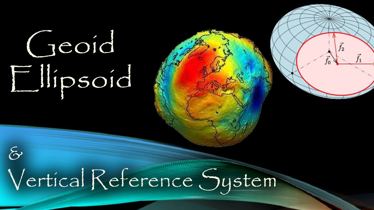
- 🌍 The Earth's irregular physical surface requires mathematical models like the physical Earth, geoid, and ellipsoid to create practical maps.
- 📊 Maps are abstractions that reduce real-world objects to suit thematic needs, showing positions, distances, sizes, and shapes of features.
- ✅ A good map must be accurate, clear, visually pleasing, and include essential elements such as title, north direction, scale, and legend.
- 🎨 Map visual design relies on color systems, symbols, and coordinate systems tailored to the projection being used.
- 🛠️ The mapping process involves preparation, determining locations, field data collection, data processing, and presentation.
- 📏 Map scales define real-world distances, for example, 1:500 scale means 1 cm on the map equals 5 meters in the field.
- 📌 Mapping can be basic (accurate positioning of physical features) or thematic (focused on specific themes requiring specialized knowledge).
- 📍 Thematic maps use polygons, lines, and points to represent themes, including socio-economic data, and must adhere to georeferencing and official standards.
- 📐 Modern mapping includes both 2D (X, Y coordinates) and 3D (X, Y, Z coordinates) representations using aerial photography, sensors, and topographic data.
- 🛰️ Base maps are created from terrestrial surveys, aerial photos, or high-resolution satellite imagery, following steps like orthorectification, digitization, and validation.
- ⚖️ Map-making must comply with legal regulations, specifically Law No. 4 of 2011 concerning geospatial information.
Q & A
What is the definition of a map according to the transcript?
-A map is an image of the Earth's surface on a flat plane, created with a certain scale and through a map projection system, which can be presented in various forms, from conventional printed maps to digital maps.
What are the three mathematical models used to represent the Earth?
-The three mathematical models are: 1) The physical Earth, representing land and water; 2) Geoid, representing the average sea level; and 3) Ellipsoid, a simplified mathematical model based on calculations.
What are the primary functions of maps?
-Maps show the position of objects, the size of areas, distances, and shapes of geographical features such as islands, administrative areas, and mountains.
What are the key conditions for a good map?
-A good map should provide a true picture, be easy to understand, visually pleasing, and include essential elements like a map title, north direction, scale, legend, clear color systems, symbols, and an appropriate coordinate system.
What is the difference between basic mapping and thematic mapping?
-Basic mapping focuses on accurately mapping fundamental elements such as rivers, roads, land areas, and boundaries. Thematic mapping focuses on specific themes, requiring specialized equipment and knowledge to interpret spatial data.
What are the stages involved in the mapping process?
-The stages include: 1) Preparation of equipment and materials, 2) Determining observation locations, 3) Collecting field coordinate data, 4) Collecting thematic data or samples, 5) Data processing, and 6) Data presentation.
How are maps classified based on scale and format?
-Maps are classified by scale into large, medium, and small scale; by storage format into printed maps (hardcopy) and digital maps (softcopy); and by visual presentation into line/vector maps and photo/raster maps.
What are thematic maps and what are their requirements?
-Thematic maps present specific themes or topics. Requirements include georeferencing, a coordinate system, classification of selected objects, consistent data criteria, adherence to thematic map standards, and use of an official base map.
What are socio-economic maps and their benefits?
-Socio-economic maps describe areas based on statistical data such as population and income. Their benefits include providing an overview of socio-economic conditions, supporting land use analysis, and informing land and socio-economic policies.
How has mapping developed with technology in terms of dimensions?
-Mapping has evolved from two-dimensional maps using X and Y coordinates to three-dimensional mapping using X, Y, and Z coordinates, which capture height information through aerial photography, sensors, or topographic data. This allows realistic 3D modeling of the Earth's surface.
What is the general process for creating a base map from satellite imagery?
-The process includes: 1) Preparation, 2) Field survey, 3) Measurement and processing of mapping control points, 4) Creation of digital elevation models, 5) Orthorectification, 6) Digitization, 7) Editing or validation, 8) Labeling geodatabase, and 9) Cartographic layout.
Outlines

Dieser Bereich ist nur für Premium-Benutzer verfügbar. Bitte führen Sie ein Upgrade durch, um auf diesen Abschnitt zuzugreifen.
Upgrade durchführenMindmap

Dieser Bereich ist nur für Premium-Benutzer verfügbar. Bitte führen Sie ein Upgrade durch, um auf diesen Abschnitt zuzugreifen.
Upgrade durchführenKeywords

Dieser Bereich ist nur für Premium-Benutzer verfügbar. Bitte führen Sie ein Upgrade durch, um auf diesen Abschnitt zuzugreifen.
Upgrade durchführenHighlights

Dieser Bereich ist nur für Premium-Benutzer verfügbar. Bitte führen Sie ein Upgrade durch, um auf diesen Abschnitt zuzugreifen.
Upgrade durchführenTranscripts

Dieser Bereich ist nur für Premium-Benutzer verfügbar. Bitte führen Sie ein Upgrade durch, um auf diesen Abschnitt zuzugreifen.
Upgrade durchführenWeitere ähnliche Videos ansehen


5.0 / 5 (0 votes)
