What Are Latitude & Longitude? | Locating Places On Earth | The Dr Binocs Show | Peekaboo Kidz
Summary
TLDRThis educational script explains the concept of latitude and longitude, essential for locating places on Earth. It describes latitudes as horizontal lines, including the Equator, and how they define climate zones. Longitudes are vertical lines, with the Prime Meridian at 0°, determining time zones. The script teaches how to find a location using coordinates, emphasizing the simplicity of this method. It concludes with a trivia fact about the total number of latitudes and longitudes.
Takeaways
- 🌐 Latitude and longitude are imaginary lines that help us locate places on Earth.
- 📏 Latitude lines run east to west, parallel to the equator, and measure distance from the equator in degrees.
- 🔄 The equator is at 0° latitude, with northern latitudes increasing to 90° at the North Pole and southern latitudes decreasing to -90° at the South Pole.
- 🌞 Important latitudes include the Tropics and the Polar Circles, which define climate zones based on sunlight.
- 🌦️ The tropical zone between the Tropics receives the most sunlight and has a warm, humid climate.
- 🍂 The temperate zone between the Tropics and Polar Circles experiences all four seasons.
- ❄️ The polar zone beyond the Polar Circles has a wintry, snowy climate due to less sunlight.
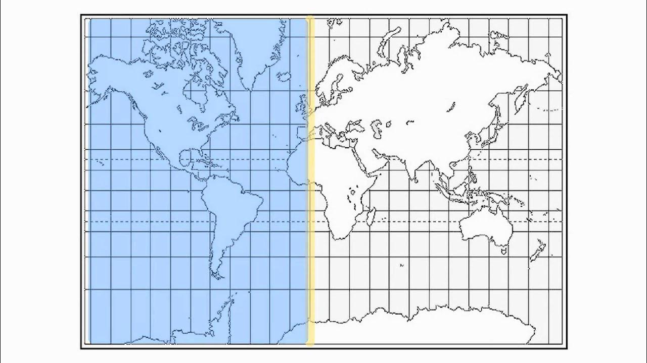
- 🌎 Longitude lines run from pole to pole, converging at the equator and meeting again at the opposite pole.
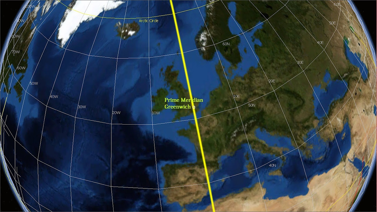
- 🕰️ The prime meridian at 0° longitude divides the Earth into Eastern and Western hemispheres and is the reference for time zones.
- ⏱️ Time differences between locations can be calculated by counting the degrees of longitude between them, with each degree representing a 4-minute difference.
- 📍 Coordinates are given as latitude followed by longitude to pinpoint a location on Earth.
Q & A
What is the purpose of the imaginary lines called latitude?
-Latitude lines are imaginary lines that run from west to east, parallel to the Equator. They measure the distance in degrees from the Equator, which helps to divide the Earth into northern and southern hemispheres and define different climate zones based on the amount of sunlight a region receives.
How is the Equator significant in terms of latitude?
-The Equator is the longest latitude line and is significant because it divides the Earth into northern and southern hemispheres. It is also the starting point for measuring latitude, with a value of 0°.
What are the important latitudes mentioned in the script?
-The important latitudes mentioned are the Tropic of Cancer, the Tropic of Capricorn, the Arctic Circle, and the Antarctic Circle. These lines help define different climate zones of the world.
What is the tropical zone and how is it defined?
-The tropical zone is the region between the Tropic of Cancer and the Tropic of Capricorn. It gets the most sunlight and is characterized by a warm and humid climate with heavy rainfall.
What is the temperate zone and how does it differ from the tropical zone?
-The temperate zone is the region between the tropics and polar circles. It has all four seasons and differs from the tropical zone in that it does not receive as much sunlight throughout the year.
What is the polar zone and what is its climate like?
-The polar zone is the region beyond the polar circles, characterized by a wintry and snowy climate due to the lack of sunlight.
What are longitude lines and how do they differ from latitude lines?
-Longitude lines are imaginary lines that run from the North Pole to the South Pole and converge at the poles. They differ from latitude lines in that they run from pole to pole and are used to determine time zones around the globe.
What is the Prime Meridian and why is it important?
-The Prime Meridian is the 0° longitude line that passes through Greenwich, near London. It is important because it divides the Earth into Eastern and Western hemispheres and is the reference point for time zones.
How do longitude lines help in determining time differences?
-Longitude lines help determine time differences by counting the number of degrees between two places. Each degree represents a 4-minute difference in time.
What are the coordinates of a location and how are they determined?
-The coordinates of a location are its latitude and longitude positions. The latitude is shown first, followed by the longitude. They help pinpoint the exact location by where these lines intersect on a map.
How many latitudes and longitudes are there in total?
-There are 180 latitudes in total, ranging from 0° at the Equator to 90° at the poles, both positive and negative. There are 360 longitudes, ranging from 0° at the Prime Meridian to 180° east and -180° west.
Outlines

Dieser Bereich ist nur für Premium-Benutzer verfügbar. Bitte führen Sie ein Upgrade durch, um auf diesen Abschnitt zuzugreifen.
Upgrade durchführenMindmap

Dieser Bereich ist nur für Premium-Benutzer verfügbar. Bitte führen Sie ein Upgrade durch, um auf diesen Abschnitt zuzugreifen.
Upgrade durchführenKeywords

Dieser Bereich ist nur für Premium-Benutzer verfügbar. Bitte führen Sie ein Upgrade durch, um auf diesen Abschnitt zuzugreifen.
Upgrade durchführenHighlights

Dieser Bereich ist nur für Premium-Benutzer verfügbar. Bitte führen Sie ein Upgrade durch, um auf diesen Abschnitt zuzugreifen.
Upgrade durchführenTranscripts

Dieser Bereich ist nur für Premium-Benutzer verfügbar. Bitte führen Sie ein Upgrade durch, um auf diesen Abschnitt zuzugreifen.
Upgrade durchführenWeitere ähnliche Videos ansehen

Latitude and Longitude
07 - Encontrando o seu lugar na Terra - Geografia - Ens. Fund. - Telecurso
How to read Latitude and Longitude Coordinates
NCERT Class 6 Geography | Chapter 2 : Globe - Latitudes and Longitudes - Part 1
Latitude and Longitude-Hommocks Earth Science Department

Geographic Grid : Latitudes and Longitudes ICSE Class 9 | @sirtarunrupani
5.0 / 5 (0 votes)
