La Tierra y las Coordenadas Geográficas - Navegación VFR
Summary
TLDREste video explica los conceptos básicos de la navegación VFR y las coordenadas geográficas. Se describe la forma casi esférica de la Tierra, su movimiento de rotación y translación, y cómo estos afectan a los fenómenos climáticos. Se introducen los puntos cardinales y se explica cómo se determinan las posiciones en la Tierra utilizando coordenadas geográficas, que se basan en el sistema de referencia WGS-84. El vídeo también detalla cómo se miden la latitud y la longitud en grados, minutos y segundos, proporcionando ejemplos prácticos para una mejor comprensión.
Takeaways
- 🌍 La Tierra es el tercer planeta del sistema solar y tiene una forma casi esférica, con una circunferencia polar de 40.009 kilómetros y equatorial de 40.075 kilómetros.
- 🌐 La forma oblate esférica de la Tierra se debe a la fuerza centrifuga causada por la rotación de la Tierra sobre su eje.
- 🌀 La Tierra tiene dos movimientos principales: rotativo (24 horas para completar una revolución) y translacional (365 días para orbitar alrededor del Sol).
- 📍 La inclinación del eje de rotación de la Tierra causa fenómenos como las estaciones, el solsticio y el equinoccio.
- 🧭 Los puntos cardinales (norte, sur, este y oeste) se pueden combinar para dar precisiones en la navegación, como noreste, sureste, suroeste y noroeste.
- 🌐 La Tierra se divide en hemisferios orientales y occidentales por el meridiano de Greenwich, y hemisferios norte y sur por el Ecuador.
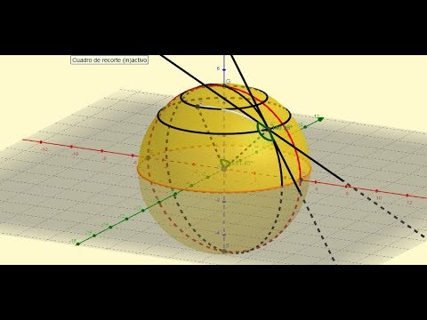
- 📈 Para determinar una posición precisa en la Tierra se utilizan las coordenadas geográficas, que son equivalentes a los ejes X e Y en un plano cartesiano.
- 🌐 Las coordenadas geográficas se basan en el sistema de referencia WGS-84 (World Geodetic System of 1984), utilizado en cartografía, geología, navegación, etc.
- 📊 La latitud indica la distancia norte o sur de un punto en relación al Ecuador, y la longitud indica la distancia este o oeste en relación al meridiano de Greenwich.
- 🕒 Las coordenadas se expresan en grados, minutos y segundos para aumentar la precisión, utilizando el sistema sexagesimal de medición angular.
Q & A
¿Cuál es la posición ordinal de la Tierra en el sistema solar?
-La Tierra es el tercer planeta del sistema solar, contando desde el sol.
¿Cómo se describe la forma de la Tierra y qué circunstancias afectan su forma?
-La forma de la Tierra es casi esférica, con una circunferencia polar de 40.009 kilómetros y equatorial de 40.075 kilómetros. Está achatada en los polos y alargada en el ecuador debido a la fuerza centrifuga que se produce al girar.
¿Qué son los dos movimientos principales de la Tierra y cuánto tiempo toman cada uno?
-Los dos movimientos principales de la Tierra son la rotación y la translación. La rotación es el movimiento de la Tierra sobre su propio eje y toma aproximadamente 24 horas para completar una revolución. La translación es el movimiento de la Tierra alrededor del sol en una órbita elíptica que dura aproximadamente 365 días.
¿Cuál es la inclinación de la Tierra respecto al plano orbital ecuatorial y cómo afecta esto?
-La inclinación de la Tierra respecto al plano orbital ecuatorial es aproximadamente de 23,5°. Esto provoca fenómenos como las estaciones, los solsticios y los equinoccios, debido a los cambios en la cantidad de luz solar que recibe cada parte de la Tierra a lo largo del año.
¿Qué son los puntos cardinales y cuáles son los cuatro principales?
-Los puntos cardinales son usados para la orientación y expresan direcciones. Los cuatro puntos cardinales principales son norte, sur, este y oeste.
¿Cómo se definen los puntos cardinales adicionales como noreste, sureste, suroeste y noroeste?
-Los puntos cardinales adicionales son combinaciones de los cuatro puntos cardinales originales, como el noreste que es el punto entre el norte y el este.
¿Qué es el Alfabeto Fonético Internacional y cómo se usa en la aviación para nombrar los puntos cardinales?
-El Alfabeto Fonético Internacional se usa en la aviación para nombrar los puntos cardinales con las letras noviembre, sierra, whisky y echo, respectivamente para norte, sur, este y oeste.
¿Cómo se dividen los hemisferios terrenales y qué líneas de referencia se usan?
-Los hemisferios terrenales se dividen en hemisferios este/oeste y norte/sur. Los hemisferios este/oeste se dividen desde el meridiano de Greenwich y los hemisferios norte/sur se dividen desde el ecuador.
¿Qué es el sistema de coordenadas geográficas y qué componentes tiene?
-El sistema de coordenadas geográficas es un sistema de referencia que permite expresar cualquier posición en términos de latitud y longitud, equivalentes a las unidades del plano cartesiano.
¿Qué son los meridianos y paralelos y cómo se miden?
-Los meridianos son arcos de gran circunferencia que se miden en grados con respecto al meridiano de Greenwich y se usan para determinar la longitud. Los paralelos son circunferencias pequeñas paralelas al ecuador y se miden en grados con respecto al ecuador para determinar la latitud.
¿Cómo se define la latitud y qué rango de valores puede tener?
-La latitud es la distancia entre el ecuador y un punto en la superficie de la Tierra, medida en grados, minutos y segundos de arco, y puede variar de 0 a 90 grados, tanto al norte como al sur del ecuador.
¿Cómo se define la longitud y qué rango de valores puede tener?
-La longitud es la distancia entre el meridiano de Greenwich y un punto en la superficie de la Tierra, medida en grados, minutos y segundos de arco, y puede variar de 0 a 180 grados, tanto al este como al oeste del meridiano de Greenwich.
¿Qué es el sistema WGS-84 y qué importancia tiene?
-El sistema WGS-84, o World Geodetic System of 1984, es el sistema de coordenadas geográficas mundial usado en cartografía, geología, navegación, etc. Permite que todas las mediciones en cualquier parte del mundo sean iguales ya que todos usan el mismo punto de referencia.
Outlines
🌍 Introducción a la Geografía y las Coordenadas Geográficas
El primer párrafo introduce el tema del vídeo, que es la discusión sobre la Tierra y sus coordenadas geográficas. Se menciona que la Tierra es el tercer planeta del Sistema Solar, casi esférica con una circunferencia polar de 40.009 kilómetros y equatorial de 40.075 kilómetros. Esta forma se debe a la fuerza centrifuga causada por la rotación de la Tierra, dando lugar a una oblate spheroid. Se explican los dos movimientos principales de la Tierra: rotacional (24 horas para completar una revolución) y translacional (365 días para orbitar alrededor del Sol en una órbita elíptica). Se enfatiza la inclinación del eje de rotación de la Tierra, que causa fenómenos como estaciones, solsticios y equinoccios. Además, se definen los puntos cardinales y cómo se pueden combinar para obtener una orientación más precisa en la navegación.
📏 Sistema de Coordenadas Geográficas
El segundo párrafo se centra en cómo se determina una posición en un plano bidimensional, utilizando el sistema de coordenadas cartesianas. Se describe cómo se puede expresar una posición en el plano cartesiano mediante dos ejes (Y y X) y una escala de unidades. Luego, se compara este sistema con el sistema de coordenadas geográficas, que utiliza dos ejes similares pero adaptados a la forma de la Tierra: la línea ecuatorial y el meridiano de Greenwich. Se explica que las coordenadas geográficas miden ángulos desde el centro de la Tierra y se expresan en grados, minutos y segundos de arco. Además, se definen las grandes circunferencias y las pequeñas circunferencias, y cómo la línea ecuatorial y el meridiano de Greenwich sirven como referencia para las coordenadas.
🌐 Definición de Latitud y Longitud
El tercer párrafo profundiza en la definición de latitud y longitud. La latitud se describe como la distancia en grados, minutos y segundos de arco entre el ecuador y un punto en la superficie de la Tierra, que puede variar de 0 a 90 grados hacia el norte o el sur del ecuador. La longitud, por otro lado, es la distancia en grados, minutos y segundos de arco entre el meridiano de Greenwich y un punto en la superficie de la Tierra, que puede variar de 0 a 180 grados hacia el este o el oeste del meridiano de Greenwich. Se ilustra cómo se pueden determinar estas coordenadas observando las escalas en un mapa y se proporcionan ejemplos prácticos para entender cómo se leen y se aplican estas coordenadas geográficas.
🗺️ Determinación de Posiciones y Sistema WGS-84
El cuarto y último párrafo del guion del vídeo enseña cómo se pueden determinar las posiciones con coordenadas geográficas observando las escalas en un mapa. Se explica cómo se identifican las posiciones en función de la latitud y la longitud, y cómo se indica si se está al norte, sur, este o oeste de un punto de referencia. Se proporcionan ejemplos específicos de cómo se determinan las coordenadas de lugares concretos. Además, se menciona el Sistema Geodésico Mundial de 1984 (WGS-84) como el sistema de coordenadas geográficas utilizado en cartografía, geología, navegación, etc., que permite que todas las mediciones en cualquier parte del mundo sean consistentes ya que todos utilizan el mismo punto de referencia.
Mindmap
Keywords
💡VFR navegación
💡Circunferencia polar
💡Circunferencia ecuatorial
💡Oblate spheroid
💡Movimiento rotativo
💡Movimiento translacional
💡Inclinación de la Tierra
💡Puntos cardinales
💡Hemisferios terrenales
💡Coordenadas geográficas
💡Meridiano
💡Paralelo
💡Sistema WGS-84
Highlights
La Tierra es el tercer planeta del sistema solar y tiene una forma casi esférica.
La circunferencia polar es de 40.009 kilómetros y la equatorial es de 40.075 kilómetros.
La forma de la Tierra es un oblate esferoide debido a la fuerza centrifuga causada por la rotación de la Tierra.
La Tierra tiene dos movimientos principales: rotacional y translacional.
La rotación de la Tierra sobre su propio eje toma aproximadamente 24 horas.
La inclinación del eje de rotación de la Tierra respecto al plano orbital alrededor del Sol es de aproximadamente 23,5°.
La inclinación del eje de la Tierra causa fenómenos como las estaciones, el solsticio y el equinoccio.
Los puntos cardinales son usados para la orientación y expresan direcciones: norte, sur, este y oeste.
Los puntos cardinales se pueden subdividir para dar mayor precisión en la expresión de una posición relativa.
En aviación, se puede usar el alfabeto fonético internacional para nombrar los puntos cardinales.
La Tierra se divide en cuatro hemisferios principales: norte, sur, este y oeste.
El meridiano de Greenwich es una línea de referencia que pasa por la ciudad de Greenwich, Inglaterra.
Los grados de latitud y longitud son equivalentes a las unidades en un plano cartesiano.
El sistema de coordenadas geográficas usa la línea ecuatorial y el meridiano de Greenwich como ejes de referencia.
Los meridianos son arcos de gran circunferencia que miden la longitud de un punto.
Las paralelas son circunferencias pequeñas paralelas a la línea ecuatorial que miden la latitud de un punto.
La latitud se mide en grados, minutos y segundos de arco desde el ecuador.
La longitud se mide en grados, minutos y segundos de arco desde el meridiano de Greenwich.
El sistema WGS-84 es el sistema de coordenadas geográficas mundial utilizado en cartografía, geología, navegación, etc.
Transcripts
Today we will talk about the earth and the geographical coordinates, but before we begin
to see the concepts of VFR navigation we must understand and learn the basic
concepts of the place where we are going to navigate that is, the earth, the earth is the third planet of
the solar system counted by from the sun and its shape is almost spherical since it has a
polar circumference of 40.009 kilometers and an equatorial circumference
of 4.075 kilometers, which means that the earth is flattened at its poles and elongated at the equator
this particular shape is due the centrifugal force that is produced
when the earth rotates resulting in a shape called an oblate spheroid
the earth has two main movements, the first is the rotational movement since
the earth rotates on its own axis and takes about 24 hours to complete
one revolution, the earth's axis of rotation is between its north pole and its south pole
now apart from this the side to which the earth rotates is known as EAST while
the opposite side is known as WEST, the other movement of the earth is the translational movement
the earth moves around the sun in an elliptical orbit that lasts approximately
365 days and the trajectory that the earth follows during this orbit is known as ecliptic
something that we must emphasize is that the earth's axis of rotation is inclined
with this ecliptic orbital plane around the sun, its inclination is approximately 23,5°
which is enough to give room for phenomena such as the seasons throughout
the year or other phenomena such as the solstice or the equinox, this occurs because the
difference in sunlight that a part of the earth receives during the year is changing
which also leads to changes of temperature and pressure and a general change in the climate
having seen these basic data on the earth we can define what the cardinal
points are, these are used for orientation and express directions and we have four
main cardinal points: north, south, east and west, however these four main points can
lead to new ones such as the northeast, the southeast, the southwest or the northwest,
which as we can see are combinations of the four original points, and although these are
the best known and most used points in navigation, these can also be further divided,
for example the point between the north and the northeast is known as
northnortheast while the point between the northeast and the east is known as the
eastnortheast and so on, thus giving greater precision when expressing
a relative position. as an additional note so as not to have to say the complete words
in aviation, the international phonetic alphabet can be used to name the cardinal points
using the letters november, sierra, whiskey or echo now another thing that we must emphasize
is that unless a universal reference system is used, each person will express
the cardinal points from their point of view, let's see an example, let's suppose that we have these
two positions a red circle and a green circle on the surface of the earth Each of these
points will have its own cardinal points if, for example, we ask someone who is
in the red circle where the green circle is, they will tell us that it is to the November Echo or northeast,
while if we ask a person In the green circle where the red circle is,
they will tell us that it is to the SIERRA WHISKEY , that is, to the southwest, in other words the
opposite cardinal point, and as we already said, unless a general
reference system is established each person will establish its relative position with respect to its point of view,
which would be more of a system to determine directions rather than to determine positions
in order to see how an exact position is actually determined on the earth
we must see some additional concepts, let's see the terrestrial hemispheres, the earth
is divided into four main hemispheres we have the eastern and western hemispheres as well
as the northern and southern hemispheres the eastern and western hemispheres are divided into starting from
the greenwich meridian which is a reference line that goes from pole to pole passing through
the city of greenwich in england while on the other hand the northern and southern hemispheres are
divided from the equator line which is a line perpendicular to the axis of rotation of
the earth and that it is at the same distance from both poles, having seen this, let's see
how we can determine a certain position. To determine a position on a plane, that
is , on a two-dimensional surface, we can use a Cartesian plane which,
as we will remember, uses two axes the Y axis and the X axis as well as a scale of units
if for example We want to express the position of this red point we would say that it is
in a position X4, Y3 because we simply count the units on each axis and put them there this
way of expressing a position is known as Cartesian coordinates and actually
using this system we can determine and express any position that is
within the scale as a function of the units for each axis, now to express a
position on the earth we use a quite similar reference system that is known
as the geographic coordinates system. This one as well as the Cartesian plane uses two axes
to determine the units in which a position is found, however these axes
are not known as Y and X and we will see next how this model adapts to the
earth. this geographic coordinate system is a system of reference that allows expressing
any position in terms of latitude and longitude. the latitude and longitude are equivalent
to the units that we had seen in the Cartesian plane, now something we must say is that
the geographic coordinate system assumes that the earth is a perfect sphere, so
we cannot use units as flat as we had used them in the Cartesian plane
but in this case the latitude and longitude are expressed in terms of angles measured from
the center of the earth using the sexagesimal degree system, which is a system
that we will see later how it is used. in other words it is the system of degrees, minutes
and seconds of arc. so far, the important thing is to know that latitude is used to express
how far north or how far south a point is, while longitude is used
to express how far east or how far west a point is, that is, the latitude
would be like the units of the Y axis while the longitude would be like the units of the X axis,
let's go now to see which ones are the axes used in the geographic coordinate system
these reference axes are the equator line and the greenwich meridian coincidentally
the same ones that divide the four terrestrial hemispheres. in order to give an accurate definition
of these two reference axes we must see what the definitions of great circle and
small circle are. A great circle is a plane in a sphere that, passing through its center, divides it
into two equal parts while a small circle is a plane in a sphere that divides it
into two unequal parts as we can Observe in this image, in other words, a great circle
would be a circumference that, passing through the surface of the earth, divides it into two
exactly equal hemispheres, while a small circle would be any
circumference that can divide the earth into two unequal parts as It can be seen in
this example, now having seen this, let's see now if the definition of the equator line
It is a great circle perpendicular to the axis of rotation of the earth which divides it into
the northern and southern hemispheres as we had seen previously, on the other hand the
greenwich meridian also known as 0 meridian is an arc of a great circle between
the north pole and the south pole that passes through the city of greenwich in england, now we can
see that here we say that it is an arc of the great circle since a great circle totally
surrounds the earth while the greenwich meridian only goes from the north pole to the South pole
so it is half of a great circle and that is why we say that it is an arc of a great circle. now
having correctly defined these two reference axes we then have something very similar to a
Cartesian plane where we have the Y axis which is now the greenwich meridian and the X axis, which is the
equator, however, due to the size of the earth, it is necessary to use
secondary reference lines that are known as meridians and parallels, let's see what these are
A meridian is an arc of a great circle between the north pole and the south pole, these meridians
are measured in degrees with respect to the 0 meridian as we can see in the image and are used as a
reference To determine the longitude of a position, that is, how far east or how far
west a point is, on the other hand, the parallels are small circles parallel to the
equator line as we can see in this image and are measured in degrees with respect to the
equator these are used as a reference to determine the latitude of a position, that is to say how far
north or how far south that point is. now although we have already seen roughly what
latitude is and what longitude is, we are going to define them correctly. The latitude is the distance
between the equator and a point on the earth's surface measured in degrees, minutes
and seconds of arc, we say that it is measured in degrees since we literally measure the angle
between the center of the earth and the zero point, which would be the line of the equator, let's see a
slightly more graphic example, here we can see that the latitude is equal to 0 degrees at the equator since it is measured
from the center of the earth towards the equator line and from there we begin to measure
the distance upwards in terms of angles until we reach 90 degrees at the poles, that is to say that
the latitude can be from 0 to 90 degrees either north or south of the equator, now Longitude has
a fairly similar definition Longitude is the distance between the 0 meridian and a
point on the earth's surface measured in degrees, minutes and seconds of arc, again we take
as a reference the center of the earth and the Greenwich meridian to be able to measure this value by
observing the graphic example we can see that then the longitude is equal to 0 in the
greenwich meridian and begins to increase in degrees until it reaches 180 degrees on the opposite side of the
0 meridian, so the longitude can be from 0 to 180 degrees either east or
west of the greenwich meridian in this image this does not seem very obvious, however here we can
see how the 180 degrees are distributed to the east and west.. and in this image from
a higher perspective, now here in this image we can see all the concepts that we have just
seen about the geographical coordinates and how the position on the earth is determined having
then seen all this theory we can go on to practice here then we are going to draw the two
axes the 0 meridian and the equator, as an additional note in this map they are not correctly
represented however it is enough to understand the concept suppose we want to
determine the position of this red circle the first thing is to determine the latitude that is how
far north or how far south it is. here we can read on the scale that is 40
degrees north while the longitude, that is, how far east or how far west it is
we can see that the scale indicates 100 degrees west therefore the
coordinates of this point would be 40 degrees north 100 degrees west It is always important
when expressing a coordinate that the latitude is given first and then the longitude, and as we can
see in this way we can determine any other position on this map for example this
other point would be 20 degrees north 40 degrees east while this other point would be 60 degrees
south 40 degrees west Since we have seen how these geographical coordinates are used up to
now, we have only seen how they are applied with degrees but previously we had said
that degrees, minutes and seconds are used, which is known as the sexagesimal system and that is,
degrees are not enough to determine a precise position because it gives a large amount of error
therefore we must use even smaller scales to be able to increase the precision and it is that each
degree is divided into 60 minutes of arc, so between degree and degree there are 60 minutes
now in turn each minute can be divided into 60 seconds of arc so that between minute and
minute there are 60 seconds of arc. We can see then that the scale becomes
smaller and smaller which in turn makes it more precise, let's see an example of how these three
combined units are used, here we have a Cartesian plane that is on a really small scale
where the minutes and seconds of arc can be appreciated
let's say we want to express the position of this red point first then we are going to observe the
latitude that is to say how far north or how far south it is here we can then see that it is at
51 degrees to the north 0 minutes and 15 seconds then we observe the longitude that is to say how far east or
how far west it is in this case it is at 11 degrees 1 minute and 30 seconds
east as you can see in this way we combine the degrees, the minutes and the seconds, giving
a much more precise position, let's see this other example, suppose then this red point
it would be 51 degrees 2 minutes 0 seconds north and 11 degrees 1 minute and 0 seconds east
now seen this, let's see how we can determine if we are north south east or west
only by observing the scale let's see this example suppose we want to determine
this position as we can see it is not specified if we are north south east west only
the degrees of the scale are given. first then we are going to determine the latitude as
we can observe the line 0 that is to say 0 degrees corresponds to the equator is below the
point A, so that means we are north of the equator and we can observe on the scale that it
is one degree is to say that we are one degree to the north, let's now see the scale about
the longitude in this case we do not have a 0 to refer to. However, we can see
that the scale is decreasing to the right, that is to say that 0 degrees of longitude is to the
right of the scale, which means that we are to the left of that meridian of Greenwich, which would
mean that we are in the western hemisphere, so we are 1 degree north and
74 degrees west, we can see position B that is one degree south and 73 degrees 30 minutes
west. we say 30 minutes since it is between 73 and 74 degrees and the midpoint as we know
between both degrees there are 60 minutes, then 30 minutes, point C would be determined by the
coordinates 0 degrees 30 minutes south 72 degrees 30 minutes west let's see a more concrete example with
a map let's see then that we want to determine the position of Germania in terms of latitude
German is slightly below 28 degrees 30 minutes that is to say that we are
at 28 degrees 29 minutes to the north we say north since if we observe the scale the
0 would be below us that is to say that we are north of the equator, on the other hand
in the longitude we can see that we are a little beyond 74 degrees 20 minutes west
with which we could say that we are 74 degrees 22 minutes west again we say west
since the scale is increasing towards the left which indicates that we are to the west
of the greenwich meridian now if we want to determine the position for example of the
Esmeralda population we would say that it is at 27 degrees 45 minutes north and 73 degrees 0 minutes to the west
and finally for example miraflores would be at a latitude of 29 degrees 20 minutes north and a
longitude of 73 degrees 35 minutes west now this coordinate system that we have been using
and that has such precise and well-defined reference systems is known as the WGS-84 system
world geodetic system of 1984 this is the world geographic coordinate system
used in cartography, geology, navigation etc. that allows all measurements in
any part of the world to be the same since everyone uses the same reference point
I hope this video has helped you to understand what geographic coordinates are
as well as refresh some basic information about the earth subscribe for more content about the
aeronautical world and leave in the comments what other types of topics you would like me to cover in the videos
5.0 / 5 (0 votes)